File:Brunig-Napf-Reuss-Linie.png
Jump to navigation
Jump to search
No higher resolution available.
Brunig-Napf-Reuss-Linie.png (800 × 543 pixels, file size: 201 KB, MIME type: image/png)
Captions
Captions
Add a one-line explanation of what this file represents

|
This map image could be re-created using vector graphics as an SVG file. This has several advantages; see Commons:Media for cleanup for more information. If an SVG form of this image is available, please upload it and afterwards replace this template with
{{vector version available|new image name}}.
It is recommended to name the SVG file “Brunig-Napf-Reuss-Linie.svg”—then the template Vector version available (or Vva) does not need the new image name parameter. |
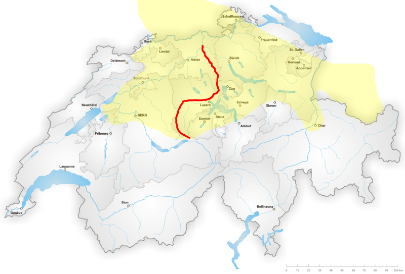
Deutsch: Ungefährer der Brünig-Napf-Reuss-Linie. Gelb das Gebiet des Hochalemannischen; Karte: basiert auf Image:Swiss languages.png
Die Datei stammt von 2006 und repräsentiert eine sehr grobe Darstellung der Linie aufgrund der verbalen Definition.
Hier ist (via google books preview) eine Reproduktion der graphischen Darstellung der Linie von 1951. Diese Datei sollte entsprechend angepasst werden.

|
Permission is granted to copy, distribute and/or modify this document under the terms of the GNU Free Documentation License, Version 1.2 or any later version published by the Free Software Foundation; with no Invariant Sections, no Front-Cover Texts, and no Back-Cover Texts. A copy of the license is included in the section entitled GNU Free Documentation License. |
| This file is licensed under the Creative Commons Attribution-Share Alike 3.0 Unported license. | ||
| ||
| This licensing tag was added to this file as part of the GFDL licensing update. |
File history
Click on a date/time to view the file as it appeared at that time.
| Date/Time | Thumbnail | Dimensions | User | Comment | |
|---|---|---|---|---|---|
| current | 07:38, 9 October 2006 | | 800 × 543 (201 KB) | Dbachmann (talk | contribs) | correction: Chur |
| 07:23, 9 October 2006 |  | 800 × 543 (200 KB) | Dbachmann (talk | contribs) | ||
| 17:32, 8 October 2006 |  | 800 × 543 (210 KB) | Dbachmann (talk | contribs) | Verlauf der Brünig-Napf-Reuss-Linie basiert auf Image:Swiss languages.png {{GFDL}} Category:Maps of Switzerland |
You cannot overwrite this file.
File usage on Commons
There are no pages that use this file.
File usage on other wikis
The following other wikis use this file:
- Usage on als.wikipedia.org
- Usage on ar.wikipedia.org
- Usage on ast.wikipedia.org
- Usage on br.wikipedia.org
- Usage on da.wikipedia.org
- Usage on de.wikipedia.org
- Usage on en.wikipedia.org
- Usage on es.wikipedia.org
- Usage on fr.wikipedia.org
- Usage on gl.wikipedia.org
- Usage on it.wikipedia.org
- Usage on nl.wikipedia.org
- Usage on ru.wikipedia.org
- Usage on sq.wikipedia.org
- Usage on uk.wikipedia.org
- Usage on zh-yue.wikipedia.org
- Usage on zh.wikipedia.org