File:Belgians in the Netherlands and Dutch in Belgium.png
Jump to navigation
Jump to search

Size of this preview: 420 × 599 pixels. Other resolutions: 168 × 240 pixels | 616 × 878 pixels.
Original file (616 × 878 pixels, file size: 220 KB, MIME type: image/png)
Captions
Captions
Add a one-line explanation of what this file represents
Legend[edit]
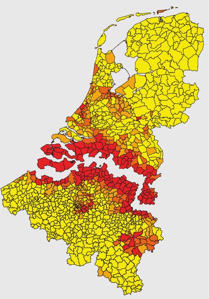
Concentration index
Less than 50.
50 to 80.
80 to 120.
120, or more.
Summary[edit]
| Description |
English: A map on the concentration of Belgians in the Netherlands and Dutchmen in Belgium per municipality. |
| Date | |
| Source | [1]. HP1740-B moved the caption to text. |
| Author | HP1740-B |
Licensing[edit]

|
The copyright holder of this file, Centraal Bureau voor de Statistiek, allows anyone to use it for any purpose, provided that the copyright holder is properly attributed. Redistribution, derivative work, commercial use, and all other use is permitted. |
Attribution:
|
File history
Click on a date/time to view the file as it appeared at that time.
| Date/Time | Thumbnail | Dimensions | User | Comment | |
|---|---|---|---|---|---|
| current | 11:29, 28 April 2018 | | 616 × 878 (220 KB) | Amphicoelias (talk | contribs) | Higher quality image taken from the pdf accompanying the image. |
| 15:58, 30 July 2009 |  | 351 × 443 (75 KB) | HP1740-B~commonswiki (talk | contribs) | ~~~~ | |
| 15:56, 30 July 2009 |  | 351 × 443 (28 KB) | HP1740-B~commonswiki (talk | contribs) | {{Information |Description={{en|1=A map on the concentration of Belgians in the Netherlands and Dutchmen in Belgium per municipality. }} |Source=Own work by uploader |Author=HP1740-B |Date=30-7-2009 |Permission= |other_versions= }} {{leg |
You cannot overwrite this file.
File usage on Commons
The following page uses this file:
- File:Belgians in the Netherlands.png (file redirect)
File usage on other wikis
The following other wikis use this file:
- Usage on de.wikipedia.org