File:NATO partnerships.svg
Jump to navigation
Jump to search

Size of this PNG preview of this SVG file: 800 × 360 pixels. Other resolutions: 320 × 144 pixels | 640 × 288 pixels | 1,024 × 461 pixels | 1,280 × 576 pixels | 2,560 × 1,152 pixels.
Original file (SVG file, nominally 800 × 360 pixels, file size: 1.6 MB)
Captions
Captions
Add a one-line explanation of what this file represents
Summary[edit]
| Description |
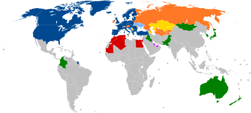
English: A global map of NATO partners around the world (with all the sovereign states that are under 20,000 km2 in area represented by a circle)
NATO member states Accession protocol signed Enhanced Opportunities Partner[1] Partnership for Peace (PfP) Français : Carte montrant les affiliations actuelles des pays européens avec l'OTAN. Les pays de moins de 20000 km2 sont représentés par un cercle.
Membres actuels Protocole d'adhésion signé Plan d'action pour l'adhésion Partenaire d'opportunités améliorées Partenariat pour la paix (PfP) Partenariat dans le monde
Português: Mapa mostrando as afiliações atuais dos países europeus com a OTAN. Os países com menos de 20.000 km2 são representados por um círculo.
Estados-membros da NATO Protocolo de Adesão Assinado Plano de Ação de Adesão Parceiros de Oportunidades Alargadas Plano de Ação de Adesão Individual Parceria para a Paz Diálogo do Mediterrâneo Iniciativa de Cooperação de Istambul Parceiros globais |
| Date | |
| Source |
This file was derived from: NATO cooperations partners.svg: |
| Author | Patrick |
| Other versions |
Derivative works of this file: Peak positions of Adele's 21 in worldwide charts.svg Derivative works of this file: NATO partnerships - 2.svg |
| SVG development |
Notes[edit]
- ↑ Partnership Interoperability Initiative. NATO (22 February 2022). Retrieved on 23 March 2022.
Licensing[edit]
I, the copyright holder of this work, hereby publish it under the following license:
This file is licensed under the Creative Commons Attribution-Share Alike 3.0 Unported license.
- You are free:
- to share – to copy, distribute and transmit the work
- to remix – to adapt the work
- Under the following conditions:
- attribution – You must give appropriate credit, provide a link to the license, and indicate if changes were made. You may do so in any reasonable manner, but not in any way that suggests the licensor endorses you or your use.
- share alike – If you remix, transform, or build upon the material, you must distribute your contributions under the same or compatible license as the original.
Original upload log[edit]
This image is a derivative work of the following images:
- NATO cooperations partners.svg licensed with Cc-by-sa-3.0
- 2012-02-06T21:37:21Z Patrickneil 800x360 (1681649 Bytes) Kosovo in gray
- 2012-02-06T21:34:07Z Patrickneil 800x360 (1681641 Bytes) Forgot Finland and Sweden
- 2012-02-06T21:26:54Z Patrickneil 800x360 (1692374 Bytes) Darker gray for non-affiliated countries
- 2012-02-06T21:23:31Z Patrickneil 800x360 (1682546 Bytes) trimming some of Micronesia for standard width of 800px
- 2012-02-06T21:11:00Z Patrickneil 842x358 (1688505 Bytes) == {{int:filedesc}} == {{Information |Description={{en|1=A global map of the world, with all the [[:en:List of countries and outlying territories by total area|sovereign states that are under 20,000 km2 in area]] represented
Uploaded with derivativeFX
File history
Click on a date/time to view the file as it appeared at that time.
| Date/Time | Thumbnail | Dimensions | User | Comment | |
|---|---|---|---|---|---|
| current | 15:45, 7 March 2024 | | 800 × 360 (1.6 MB) | Janitoalevic (talk | contribs) | Sweden added |
| 21:59, 3 April 2023 |  | 800 × 360 (1.6 MB) | Louloumra59 (talk | contribs) | FIN | |
| 16:00, 3 April 2023 |  | 800 × 360 (1.6 MB) | CD967119 (talk | contribs) | They will join Tuesday, not today. | |
| 15:13, 3 April 2023 |  | 800 × 360 (1.6 MB) | Edroeh (talk | contribs) | FIN | |
| 14:02, 31 March 2023 |  | 800 × 360 (1.6 MB) | Invinciblewalnut (talk | contribs) | Reverted to version as of 07:57, 10 August 2022 (UTC) | |
| 13:39, 31 March 2023 |  | 800 × 360 (1.55 MB) | Invinciblewalnut (talk | contribs) | changed color of sweden and finland to reflect ongoing accession process | |
| 07:57, 10 August 2022 |  | 800 × 360 (1.6 MB) | Zarwada (talk | contribs) | == {{int:filedesc}} == {{Information |Description={{en|1=A global map of NATO partners around the world, with all the {{W|List of countries and outlying territories by total area|sovereign states that are under 20,000 km<sup>2</sup> in area}} represented by a circle. {{legtab|#004990 thin solid transparent|NATO {{W|Member states of NATO|member}} states |#2A7FFF thin solid transparent|{{W|Membership Action Plan}} |#88B7FF thin solid transparent|Enhanced Opportunities Partner<ref>{{cite web |... | |
| 19:43, 24 July 2022 |  | 800 × 360 (1.6 MB) | Kwamikagami (talk | contribs) | rs. recent fixes, rm. non-countries | |
| 19:21, 24 July 2022 |  | 800 × 360 (1.6 MB) | Kwamikagami (talk | contribs) | restore Kosovo - Reverted to version as of 16:21, 27 March 2020 (UTC) | |
| 09:29, 22 July 2022 |  | 2,754 × 1,398 (1.09 MB) | Kwamikagami (talk | contribs) | NATO blue, #004990 |
You cannot overwrite this file.
File usage on Commons
The following 6 pages use this file:
File usage on other wikis
The following other wikis use this file:
- Usage on af.wikipedia.org
- Usage on ar.wikipedia.org
- حلف شمال الأطلسي
- حوار متوسطي
- الشراكة من أجل السلام
- علاقات حلف الناتو الخارجية
- قالب:علاقات حلف الناتو
- جمعية حلف الأطلسي
- مجلس الشراكة الأوروبية الأطلسية
- مبادرة اسطنبول للتعاون
- العلاقات بين روسيا وحلف شمال الأطلسي
- علاقات ألبانيا والناتو
- العلاقات بين أوكرانيا وحلف الناتو
- العلاقات بين جورجيا والناتو
- انضمام البوسنة والهرسك إلى الناتو
- العلاقات بين السويد وحلف الناتو
- العلاقات بين النمسا وحلف الناتو
- Usage on ast.wikipedia.org
- Usage on az.wikipedia.org
- Usage on be-tarask.wikipedia.org
- Usage on bg.wikipedia.org
- Usage on ca.wikipedia.org
- Usage on cs.wikipedia.org
- Usage on da.wikipedia.org
- Usage on de.wikipedia.org
- Usage on el.wikipedia.org
- Usage on en.wikipedia.org
- NATO
- Euro-Atlantic Partnership Council
- Partnership for Peace
- Atlantic Treaty Association
- Mediterranean Dialogue
- Individual Partnership Action Plan
- Istanbul Cooperation Initiative
- Georgia–NATO relations
- Romania in NATO
- Canada in NATO
- Ukraine–NATO relations
- Russia–NATO relations
- Talk:NATO
- Croatia–NATO relations
- Albania–NATO relations
- Montenegro–NATO relations
- North Macedonia–NATO relations
- Template:NATO relations
- Talk:NATO/Archive 3
- Moldova–NATO relations
- Bosnia and Herzegovina–NATO relations
- NATO logistics in the Afghan War
- User:Patrickneil/NATO
- Foreign relations of NATO
- Pakistan–NATO relations
View more global usage of this file.