File:Is-wb-gs-gh.png

Original file (1,428 × 2,289 pixels, file size: 259 KB, MIME type: image/png)
Captions
Captions
Summary[edit]
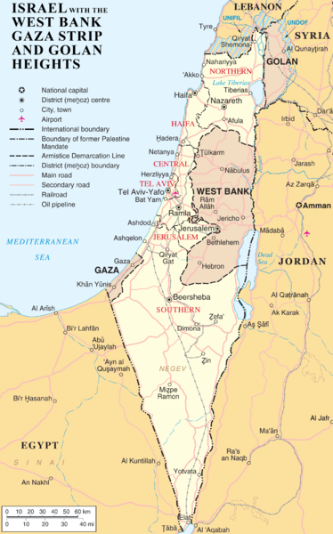
| Description | en:Category:Maps of the Palestinian territories |
| Date |
1 April 2007 (original upload date) |
| Source |
Transferred from en.wikipedia to Commons. |
| Author | (Original text: ChrisO) |
Licensing[edit]
| This work has been released into the public domain by its author, ChrisO at English Wikipedia. This applies worldwide. In some countries this may not be legally possible; if so: ChrisO grants anyone the right to use this work for any purpose, without any conditions, unless such conditions are required by law. |
| This image is a map derived from a United Nations map.
Unless stated otherwise, UN maps are to be considered in the public domain. This applies worldwide. UN maps are, in principle, open source material and you can use them in your work or for making your own map. UN requests however that you delete the UN name, logo and reference number upon any modification to the map. Content of your map will be your responsibility. You can state in your publication, if you wish, something like: based on UN map … (map name, map number, revision number and date). See: Geospatial Information Section. And: Geospatial, location data for a better world. |
 |
Original upload log[edit]
- 2007-04-01 21:20 ChrisO 1428×2289×8 (264954 bytes)
- 2007-04-01 19:55 ChrisO 1428×2289×8 (265283 bytes) == Summary == {{Information |Description= {{en|Map of [[Israel]], the [http://en.wikipedia.org/wiki/Palestinian_territories Palestinian territories] ([[West Bank]] and [[Gaza Strip]]), the [[Golan Heights]], and portions of neighbouring countries. Also [[
File history
Click on a date/time to view the file as it appeared at that time.
| Date/Time | Thumbnail | Dimensions | User | Comment | |
|---|---|---|---|---|---|
| current | 15:09, 2 July 2007 | | 1,428 × 2,289 (259 KB) | Liftarn (talk | contribs) | {{Information |Description=en:Category:Maps of Israel en:Category:Maps of the Palestinian territories |Source=Originally from [http://en.wikipedia.org en.wikipedia]; description page is/was [http://en.wikipedia.org/w/index.php?title=Image%3AIs-w |
You cannot overwrite this file.
File usage on Commons
The following page uses this file:
File usage on other wikis
The following other wikis use this file:
- Usage on da.wikipedia.org