File:Frozenground.gif
Jump to navigation
Jump to search
No higher resolution available.
Frozenground.gif (352 × 350 pixels, file size: 34 KB, MIME type: image/gif)
Captions
Captions
Add a one-line explanation of what this file represents
Summary[edit]
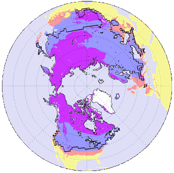
English: Distributions of permafrost in the Northern Hemisphere.
- purple region : permafrost
- blue regions : seasonally frozen ground (the soil is frozen for 15 days or more per year )
- pink regions : intermittently frozen ground ( the soil is frozen for fewer than 15 days per year )
- solid line : the average maximum extent of the seasonal snow cover
Русский: Районы вечной мерзлоты северного полушария.
- Фиолетовый: регионы вечной мерзлоты;
- Синий: регионы, где почва замерзает более, чем на 15 суток в году;
- Розовый: регионы, где почва замерзает менее, чем на 15 суток в году;
- Сплошная линия: граница области, где зимой выпадает снег.
日本語: 北半球での凍土の分布。
- 紫:永久凍土
- 青:季節的凍土(土壌の凍結が年間15日以上の地域)
- ピンク:季節的凍土(土壌の凍結が年間15日以下の地域)
- 黒線:積雪地域南限(平均)
Licensing[edit]
The original public domain NASA picture modified by me (-map legend, black background > white, smaller size).
| This file is in the public domain in the United States because it was solely created by NASA. NASA copyright policy states that "NASA material is not protected by copyright unless noted". (See Template:PD-USGov, NASA copyright policy page or JPL Image Use Policy.) | ||
 |
Warnings:
|

|
This map of the world image could be re-created using vector graphics as an SVG file. This has several advantages; see Commons:Media for cleanup for more information. If an SVG form of this image is available, please upload it and afterwards replace this template with
{{vector version available|new image name}}.
It is recommended to name the SVG file “Frozenground.svg”—then the template Vector version available (or Vva) does not need the new image name parameter. |
File history
Click on a date/time to view the file as it appeared at that time.
| Date/Time | Thumbnail | Dimensions | User | Comment | |
|---|---|---|---|---|---|
| current | 12:02, 19 June 2016 | | 352 × 350 (34 KB) | SteinsplitterBot (talk | contribs) | Bot: Image rotated by 270° |
| 18:10, 3 July 2005 |  | 350 × 352 (33 KB) | Adam~commonswiki (talk | contribs) | Distributions of permafrost in the Northern Hemispher. *purple region : permafrost *blue regions : seasonally frozen ground (the soil is frozen for 15 days or more per year ) *pink regions : intermittently frozen ground ( the soil is frozen for fewer t | |
| 01:00, 18 April 2005 |  | 350 × 372 (33 KB) | Ktz~commonswiki (talk | contribs) | Distributions of permafrost in the Nortern Hemispher. {{PD-USGov-NASA}} http://earthobservatory.nasa.gov/Study/FrozenSoils/ |
You cannot overwrite this file.
File usage on Commons
The following 3 pages use this file:
File usage on other wikis
The following other wikis use this file:
- Usage on ar.wikipedia.org
- Usage on ast.wikipedia.org
- Usage on az.wikipedia.org
- Usage on be-tarask.wikipedia.org
- Usage on be.wikipedia.org
- Usage on bg.wikipedia.org
- Usage on bn.wikipedia.org
- Usage on cdo.wikipedia.org
- Usage on cv.wikipedia.org
- Usage on da.wikipedia.org
- Usage on en.wikipedia.org
- Usage on eo.wikipedia.org
- Usage on es.wikipedia.org
- Usage on es.wikibooks.org
- Usage on et.wikipedia.org
- Usage on fi.wikipedia.org
- Usage on fr.wikipedia.org
- Usage on fy.wikipedia.org
- Usage on hu.wikipedia.org
- Usage on hy.wikipedia.org
- Usage on ilo.wikipedia.org
- Usage on ja.wikipedia.org
- Usage on jv.wikipedia.org
- Usage on kn.wikipedia.org
- Usage on la.wikipedia.org
- Usage on li.wikipedia.org
- Usage on lv.wikipedia.org
- Usage on ms.wikipedia.org
- Usage on nl.wikipedia.org
- Usage on nn.wikipedia.org
- Usage on no.wikipedia.org
- Usage on pa.wikipedia.org
- Usage on pl.wikipedia.org
- Usage on pt.wikipedia.org
- Usage on ru.wikipedia.org
- Usage on sah.wikipedia.org
- Usage on sk.wikipedia.org
- Usage on sq.wikipedia.org
- Usage on sr.wikipedia.org
- Usage on ta.wikipedia.org
- Usage on te.wikipedia.org
- Usage on tr.wikipedia.org
- Usage on uk.wikipedia.org
- Usage on vi.wikipedia.org
- Usage on wuu.wikipedia.org
- Usage on zh.wikipedia.org