File:Europe map 450.PNG
Jump to navigation
Jump to search
No higher resolution available.
Europe_map_450.PNG (800 × 580 pixels, file size: 145 KB, MIME type: image/png)
Captions
Captions
Add a one-line explanation of what this file represents

|
This historical map image could be re-created using vector graphics as an SVG file. This has several advantages; see Commons:Media for cleanup for more information. If an SVG form of this image is available, please upload it and afterwards replace this template with
{{vector version available|new image name}}.
It is recommended to name the SVG file “Europe map 450.svg”—then the template Vector version available (or Vva) does not need the new image name parameter. |
Summary[edit]
Español: Europa en el 450.
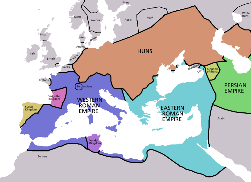
Map of Europe in 450 AD, based on free map of europe Image:BlankMap-Europe.png. Many of the border lines are approximations. Information from Penguin Atlas of Medieval History - and Harper Collins Atlas of World History ed. by Geoffrey Barraclough, second revised edition 1989 pp. 88-89 and pp. 106-107
_en.png)
.png)
.jpg)
Licensing[edit]

|
Permission is granted to copy, distribute and/or modify this document under the terms of the GNU Free Documentation License, Version 1.2 or any later version published by the Free Software Foundation; with no Invariant Sections, no Front-Cover Texts, and no Back-Cover Texts. A copy of the license is included in the section entitled GNU Free Documentation License. |
| This file is licensed under the Creative Commons Attribution-Share Alike 3.0 Unported license. | ||
| ||
| This licensing tag was added to this file as part of the GFDL licensing update. |
File history
Click on a date/time to view the file as it appeared at that time.
| Date/Time | Thumbnail | Dimensions | User | Comment | |
|---|---|---|---|---|---|
| current | 22:30, 4 April 2009 | | 800 × 580 (145 KB) | DJ Sturm (talk | contribs) | Detailed Northern Europa |
| 02:52, 12 January 2007 |  | 800 × 580 (141 KB) | Roke~commonswiki (talk | contribs) | ||
| 13:38, 5 May 2006 |  | 2,275 × 1,649 (111 KB) | Roke~commonswiki (talk | contribs) | Map of Europe in 220BC, based on free map of europe Image:BlankMap-Europe.png. Many of the border lines are approximations. {{Europe}} Category: Historical maps of Europe |
You cannot overwrite this file.
File usage on Commons
The following 5 pages use this file:
File usage on other wikis
The following other wikis use this file:
- Usage on af.wikipedia.org
- Usage on ar.wikipedia.org
- Usage on ast.wikipedia.org
- Usage on bs.wikipedia.org
- Usage on ckb.wikipedia.org
- Usage on cs.wikipedia.org
- Usage on da.wikipedia.org
- Usage on de.wikipedia.org
- Usage on el.wikipedia.org
- Usage on en.wikipedia.org
- Usage on en.wiktionary.org
- Usage on eo.wikipedia.org
- Usage on es.wikipedia.org
- Usage on es.wikiquote.org
- Usage on et.wikipedia.org
- Usage on fa.wikipedia.org
- Usage on fi.wikipedia.org
- Usage on fr.wikipedia.org
- Usage on fy.wikipedia.org
- Usage on gl.wikipedia.org
- Usage on he.wikipedia.org
- Usage on hr.wikipedia.org
- Usage on hu.wikipedia.org
- Usage on hy.wikipedia.org
- Usage on id.wikipedia.org
- Usage on io.wikipedia.org
- Usage on it.wikipedia.org
- Usage on ja.wikipedia.org
- Usage on ko.wikipedia.org
- Usage on ku.wikipedia.org
- Usage on lt.wikipedia.org
- Usage on mk.wikipedia.org
View more global usage of this file.