File:American major non-NATO allies.svg
Jump to navigation
Jump to search

Size of this PNG preview of this SVG file: 800 × 406 pixels. Other resolutions: 320 × 162 pixels | 640 × 325 pixels | 1,024 × 520 pixels | 1,280 × 650 pixels | 2,560 × 1,300 pixels | 2,756 × 1,399 pixels.
Original file (SVG file, nominally 2,756 × 1,399 pixels, file size: 857 KB)
Captions
Captions
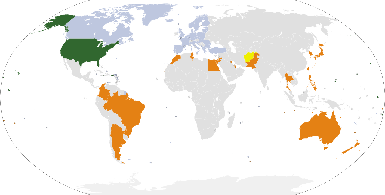
Map showing major non-NATO allies of the United States
Summary[edit]
| Description |
English: Major non-NATO allies of the United States as designated by U.S. law.
United States
Major Non-NATO Allies
Former Major Non-NATO Allies
NATO allies |
| Date | |
| Source | Own work |
| Author | Vcardozobr |
| Other versions |
|

Licensing[edit]
I, the copyright holder of this work, hereby publish it under the following license:
This file is licensed under the Creative Commons Attribution-Share Alike 4.0 International license.
- You are free:
- to share – to copy, distribute and transmit the work
- to remix – to adapt the work
- Under the following conditions:
- attribution – You must give appropriate credit, provide a link to the license, and indicate if changes were made. You may do so in any reasonable manner, but not in any way that suggests the licensor endorses you or your use.
- share alike – If you remix, transform, or build upon the material, you must distribute your contributions under the same or compatible license as the original.
New version with the whole NATO shaded in light green[edit]
I added NATO to the map to visualize the scale of NATO alliances found here: https://commons.wikimedia.org/wiki/File:Major_Non-NATO_Ally_designated_by_the_United_States_(2020).svg
.svg)
File history
Click on a date/time to view the file as it appeared at that time.
| Date/Time | Thumbnail | Dimensions | User | Comment | |
|---|---|---|---|---|---|
| current | 20:12, 8 March 2024 | | 2,756 × 1,399 (857 KB) | Iktsokh (talk | contribs) | Sweden |
| 17:07, 4 April 2023 |  | 2,756 × 1,399 (813 KB) | Hanzlan (talk | contribs) | NATO+Finland | |
| 18:01, 6 November 2022 |  | 2,756 × 1,399 (813 KB) | Danlaycock (talk | contribs) | Add former MNNA in yellow | |
| 21:34, 25 July 2022 |  | 2,756 × 1,399 (813 KB) | M.Bitton (talk | contribs) | Reverted to version as of 21:13, 25 July 2022 (UTC): it's not as the source only mentions the states and not the international borders | |
| 21:17, 25 July 2022 |  | 2,756 × 1,399 (813 KB) | Kwamikagami (talk | contribs) | actually, this is precisely what the US thinks. it's determined by US law. | |
| 21:13, 25 July 2022 |  | 2,756 × 1,399 (813 KB) | Kwamikagami (talk | contribs) | color territories, no dots | |
| 11:51, 25 July 2022 |  | 2,756 × 1,399 (812 KB) | M.Bitton (talk | contribs) | rv recent change. This map is about the American allies and not what the U.S. thinks | |
| 10:28, 25 July 2022 |  | 2,756 × 1,399 (812 KB) | Kwamikagami (talk | contribs) | more NATO-like color for NATO allies | |
| 08:38, 25 July 2022 |  | 2,756 × 1,399 (812 KB) | Kwamikagami (talk | contribs) | de facto Sahrawi border; US recognizes Morroccan control of W.Sahara | |
| 08:29, 25 July 2022 |  | 2,756 × 1,399 (812 KB) | Kwamikagami (talk | contribs) | greenland, faroes; rs. old grey |
You cannot overwrite this file.
File usage on Commons
The following 2 pages use this file:
- File:American-MNNA-2019.svg (file redirect)
- File:American MNNA and NATO allies.svg
File usage on other wikis
The following other wikis use this file:
- Usage on ar.wikipedia.org
- Usage on arz.wikipedia.org
- Usage on az.wikipedia.org
- Usage on be.wikipedia.org
- Usage on cs.wikipedia.org
- Usage on da.wikipedia.org
- Usage on de.wikipedia.org
- Usage on en.wikipedia.org
- Usage on es.wikipedia.org
- Usage on fa.wikipedia.org
- Usage on fi.wikipedia.org
- Usage on fr.wikipedia.org
- Usage on he.wikipedia.org
- Usage on id.wikipedia.org
- Usage on it.wikipedia.org
- Usage on ja.wikipedia.org
View more global usage of this file.