File:AchaemenidMapBehistunInscription.png
Jump to navigation
Jump to search

Size of this preview: 800 × 511 pixels. Other resolutions: 320 × 205 pixels | 640 × 409 pixels | 1,020 × 652 pixels.
Original file (1,020 × 652 pixels, file size: 17 KB, MIME type: image/png)
Captions
Captions
Add a one-line explanation of what this file represents
Summary[edit]
| Description |
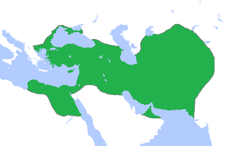
English: This a map of the Achaemenid Empire showing its greatest extent. I have given it more regions as listed on the Behistun Inscription the Persian King Darius wrote telling his conquests. |
| Date | |
| Source | http://en.wikipedia.org/wiki/File:Achemenids500BC.png |
| Author | Gabagool |
| Permission (Reusing this file) |
http://en.wikipedia.org/wiki/File:Achemenids500BC.png |
- Other information
English: This is a map I have edited from that map and it says that I am free to share, to remix, but under the following conditions that i must the work in the manner specified by the author or licensor.
This file is licensed under the Creative Commons Attribution 1.0 Generic license.
- You are free:
- to share – to copy, distribute and transmit the work
- to remix – to adapt the work
- Under the following conditions:
- attribution – You must give appropriate credit, provide a link to the license, and indicate if changes were made. You may do so in any reasonable manner, but not in any way that suggests the licensor endorses you or your use.
Licensing[edit]
This file is licensed under the Creative Commons Attribution 3.0 Unported license.
- You are free:
- to share – to copy, distribute and transmit the work
- to remix – to adapt the work
- Under the following conditions:
- attribution – You must give appropriate credit, provide a link to the license, and indicate if changes were made. You may do so in any reasonable manner, but not in any way that suggests the licensor endorses you or your use.
File history
Click on a date/time to view the file as it appeared at that time.
| Date/Time | Thumbnail | Dimensions | User | Comment | |
|---|---|---|---|---|---|
| current | 00:53, 23 October 2015 | | 1,020 × 652 (17 KB) | LouisAragon (talk | contribs) | blocked sock. |
| 02:01, 13 October 2015 |  | 1,020 × 652 (22 KB) | History of Persia (talk | contribs) | My apologies sir but they did conquer parts of arabia. See the Achaemenid Arabia article. | |
| 01:50, 13 October 2015 |  | 1,020 × 652 (17 KB) | LouisAragon (talk | contribs) | Reverted to version as of 22:39, 6 February 2015 (UTC) | |
| 01:24, 13 October 2015 |  | 1,020 × 652 (22 KB) | LouisAragon (talk | contribs) | correct. | |
| 01:21, 13 October 2015 |  | 1,020 × 652 (22 KB) | LouisAragon (talk | contribs) | They simply did not conquer those territories you just added on all sides. | |
| 23:28, 8 September 2015 |  | 1,012 × 648 (19 KB) | History of Persia (talk | contribs) | More accurate map. info on greek territories: File:Map Greco-Persian Wars-en.svg, size of Mascat (modern Oman/UAE): File:East-Hem 600bc.jpg. clay tablets in old persian have been found in bahrain, so its likely they were part of the achaemenid empire,... | |
| 00:48, 29 July 2015 |  | 1,020 × 652 (20 KB) | History of Persia (talk | contribs) | made achaemenid arabia better | |
| 00:25, 9 July 2015 |  | 1,020 × 652 (22 KB) | History of Persia (talk | contribs) | They had also conquered arabia-petrea (though it did not exist with that name) A wikipedia article of the province exists: Achaemenid Arabia | |
| 22:39, 6 February 2015 |  | 1,020 × 652 (17 KB) | HistoryofIran (talk | contribs) | I aprreciete your effort, but could you please upload the picture instead of replacing it with mine? thanks. | |
| 04:55, 29 January 2015 |  | 1,020 × 652 (59 KB) | Javierfv1212 (talk | contribs) | Updated the map by delineating the conquests of the three major Persian conqueror Kings, and also adding the names of the main satrapies of the empire. As a source I used this map of Ian Mladjov's Resources from the University of Michigan's History dep... |
You cannot overwrite this file.
File usage on Commons
There are no pages that use this file.
File usage on other wikis
The following other wikis use this file:
- Usage on ar.wikipedia.org
- Usage on be.wikipedia.org
- Usage on da.wikipedia.org
- Usage on en.wikipedia.org
- Usage on en.wikivoyage.org
- Usage on eo.wikipedia.org
- Usage on es.wikipedia.org
- Usage on fa.wikipedia.org
- Usage on fr.wikipedia.org
- Usage on gl.wikipedia.org
- Usage on hu.wikipedia.org
- Usage on hy.wikipedia.org
- Usage on id.wikibooks.org
- Usage on incubator.wikimedia.org
- Usage on it.wikipedia.org
- Usage on it.wikiversity.org
- Usage on ja.wikipedia.org
- Usage on la.wikipedia.org
- Usage on li.wikipedia.org
- Usage on mg.wikipedia.org
- Usage on ms.wikipedia.org
- Usage on no.wikipedia.org
- Usage on pl.wikipedia.org
- Usage on pnb.wikipedia.org
- Usage on ps.wikipedia.org
- Usage on ru.wikipedia.org
- Usage on simple.wikipedia.org
- Usage on sr.wikipedia.org
- Usage on te.wikipedia.org
- Usage on th.wikipedia.org
- Usage on tr.wikipedia.org
View more global usage of this file.