File:UAEOMCmap.png
Jump to navigation
Jump to search
Size of this preview: 671 × 599 pixels. Other resolutions: 269 × 240 pixels | 537 × 480 pixels | 928 × 829 pixels.
Original file (928 × 829 pixels, file size: 39 KB, MIME type: image/png)
Captions
Captions
Add a one-line explanation of what this file represents
Summary[edit]
| Description |
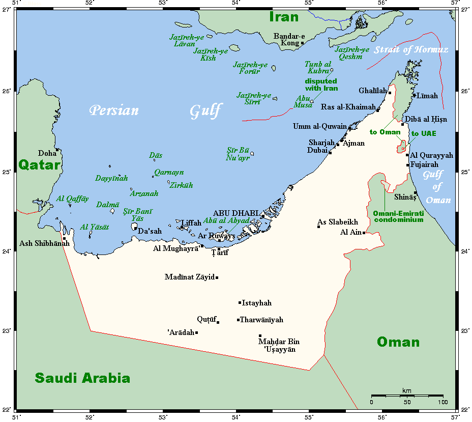
English: A map showing the UAE's cities and main towns, along with nearby areas. This map's source is here, with the uploader's modifications, and the GMT homepage says that the tools are released under the GNU General Public License. |
| Date | 20 July 2007 (original upload date) |
| Source | Transferred from en.wikipedia to Commons by Georgez. |
| Author | Kelisi at English Wikipedia |
| Other versions | العربيَّة |
Licensing[edit]
Kelisi at the English-language Wikipedia, the copyright holder of this work, hereby publishes it under the following license:
| This file is licensed under the Creative Commons Attribution-Share Alike 3.0 Unported license. Subject to disclaimers. | ||
| Attribution: Kelisi at the English-language Wikipedia | ||
| ||
| This licensing tag was added to this file as part of the GFDL licensing update. |

|
Permission is granted to copy, distribute and/or modify this document under the terms of the GNU Free Documentation License, Version 1.2 or any later version published by the Free Software Foundation; with no Invariant Sections, no Front-Cover Texts, and no Back-Cover Texts. A copy of the license is included in the section entitled GNU Free Documentation License. Subject to disclaimers. |
Original upload log[edit]
The original description page was here. All following user names refer to en.wikipedia.
- 2007-07-20 01:00 Kelisi 928×829× (31672 bytes) == Summary == A map showing the UAE's cities and main towns, along with nearby areas. This map's source is [http://www.aquarius.ifm-geomar.de/ here], with the uploader's modifications, and the [http://gmt.soest.hawaii.edu/ GMT homepage] says that the tool
File history
Click on a date/time to view the file as it appeared at that time.
| Date/Time | Thumbnail | Dimensions | User | Comment | |
|---|---|---|---|---|---|
| current | 17:54, 30 January 2021 | | 928 × 829 (39 KB) | Kelisi (talk | contribs) | The Saudi-Qatari border has been adjusted to reflect what current maps generally show. Source was Open Street Map, which I always find to be the trustworthiest in such matters (and, of course, the freest as well; so there is no copyright to worry about). |
| 15:55, 25 March 2009 |  | 928 × 829 (31 KB) | Georgez (talk | contribs) | {{Information |Description={{en|A map showing the UAE's cities and main towns, along with nearby areas. This map's source is [http://www.aquarius.ifm-geomar.de/ here], with the uploader's modifications, and the [http://gmt.soest.hawaii.edu/ GMT homepage] |
You cannot overwrite this file.
File usage on Commons
The following page uses this file:
File usage on other wikis
The following other wikis use this file:
- Usage on ar.wikipedia.org
- Usage on ca.wikipedia.org
- Usage on ckb.wikipedia.org
- Usage on en.wikipedia.org
- Usage on eo.wikipedia.org
- Usage on es.wikipedia.org
- Usage on fa.wikipedia.org
- Usage on fr.wikipedia.org
- Usage on hr.wikipedia.org
- Usage on id.wikipedia.org
- Usage on it.wikipedia.org
- Usage on ja.wikipedia.org
- Usage on nl.wikipedia.org
- Usage on nn.wikipedia.org