File:Major Philippine languages.png
Jump to navigation
Jump to search

Size of this preview: 384 × 599 pixels. Other resolutions: 154 × 240 pixels | 308 × 480 pixels | 492 × 768 pixels | 656 × 1,024 pixels | 2,000 × 3,120 pixels.
Original file (2,000 × 3,120 pixels, file size: 395 KB, MIME type: image/png)
Captions
Captions
Add a one-line explanation of what this file represents
Summary[edit]
| Description |
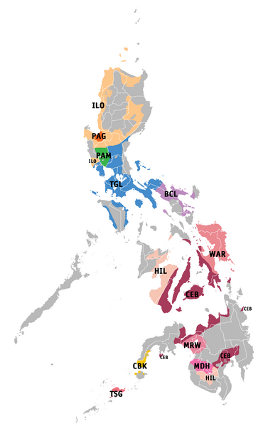
English: Language map of the 12 recognized regional Philippine languages based on maps from Ethnologue. Filipino: Mapa ng wika batay sa mga mapa ng Ethnologue ng 12 kinikilálang wikang rehiyonal sa Pilipinas. |
| Date | |
| Source | Derivative work of BlankMap-Philippines.png by User:TheCoffee |
| Author | Roel Balingit |
Licensing[edit]
I, the copyright holder of this work, hereby publish it under the following license:
This file is licensed under the Creative Commons Attribution-Share Alike 3.0 Unported license.
- You are free:
- to share – to copy, distribute and transmit the work
- to remix – to adapt the work
- Under the following conditions:
- attribution – You must give appropriate credit, provide a link to the license, and indicate if changes were made. You may do so in any reasonable manner, but not in any way that suggests the licensor endorses you or your use.
- share alike – If you remix, transform, or build upon the material, you must distribute your contributions under the same or compatible license as the original.
File history
Click on a date/time to view the file as it appeared at that time.
| Date/Time | Thumbnail | Dimensions | User | Comment | |
|---|---|---|---|---|---|
| current | 03:04, 16 July 2013 | | 2,000 × 3,120 (395 KB) | Namayan (talk | contribs) | refined ILO speaking area |
| 02:31, 23 June 2013 |  | 2,000 × 3,120 (395 KB) | Namayan (talk | contribs) | Stripped areas where ILO and Inlaod Itneg are jointly spoken | |
| 04:50, 10 June 2013 |  | 2,000 × 3,120 (395 KB) | Namayan (talk | contribs) | Unshaded CEB area in Leyte province where Baybayanon is spoken | |
| 11:28, 2 June 2013 |  | 2,000 × 3,120 (395 KB) | Namayan (talk | contribs) | Ushaded CEB areas where Bantayanon is spoken. Final upload, after completed language map for 172 languages | |
| 17:04, 30 May 2013 |  | 2,000 × 3,120 (395 KB) | Namayan (talk | contribs) | Restored MRW shade | |
| 16:51, 30 May 2013 |  | 2,000 × 3,120 (393 KB) | Namayan (talk | contribs) | added ILO areas in Abra province | |
| 09:44, 30 May 2013 |  | 2,000 × 3,120 (395 KB) | Namayan (talk | contribs) | Unshaded ares in ILO area in Cagayan belonging to another language | |
| 09:05, 30 May 2013 |  | 2,000 × 3,120 (395 KB) | Namayan (talk | contribs) | Added CEB areas in Dinagat island and Southern Leyte. Striped TGL, CEB, CBK areas identified as mixed languages. Unshaded BCL areas belonging to other language | |
| 22:37, 26 May 2013 |  | 2,000 × 3,120 (394 KB) | Namayan (talk | contribs) | Added other CEB regions in Agusan and Surigao | |
| 22:06, 26 May 2013 |  | 2,000 × 3,120 (393 KB) | Namayan (talk | contribs) | Removed MDH shade on Iranun speaking regions, nudged labels, resized text. |
You cannot overwrite this file.
File usage on Commons
There are no pages that use this file.
File usage on other wikis
The following other wikis use this file:
- Usage on bcl.wikipedia.org
- Usage on ceb.wikipedia.org
- Usage on en.wikipedia.org
- Usage on ilo.wikipedia.org
- Usage on ko.wikipedia.org
- Usage on ml.wikipedia.org
- Usage on pag.wikipedia.org
- Usage on pam.wikipedia.org
- Usage on tl.wikipedia.org
- Usage on tr.wikipedia.org
- Usage on war.wikipedia.org