File:Ciudades de Sumeria.svg
Jump to navigation
Jump to search

Size of this PNG preview of this SVG file: 465 × 512 pixels. Other resolutions: 218 × 240 pixels | 436 × 480 pixels | 697 × 768 pixels | 930 × 1,024 pixels | 1,860 × 2,048 pixels.
Original file (SVG file, nominally 465 × 512 pixels, file size: 180 KB)
Captions
Captions
Add a one-line explanation of what this file represents
Summary[edit]
| Description |
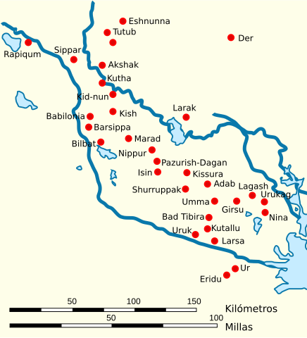
Español: Mapa de la localización de las principales ciudades de Sumeria y Elam |
| Date | |
| Source | Own work, based on this work by User:John D. Croft |
| Author | Crates |
| Permission (Reusing this file) |
CC-BY |
| Other versions |
[]
|

.svg)

.svg)
.svg)

.svg)


.svg)

.svg)
Licensing[edit]
I, the copyright holder of this work, hereby publish it under the following licenses:

|
Permission is granted to copy, distribute and/or modify this document under the terms of the GNU Free Documentation License, Version 1.2 or any later version published by the Free Software Foundation; with no Invariant Sections, no Front-Cover Texts, and no Back-Cover Texts. A copy of the license is included in the section entitled GNU Free Documentation License. |
This file is licensed under the Creative Commons Attribution 3.0 Unported license.
- You are free:
- to share – to copy, distribute and transmit the work
- to remix – to adapt the work
- Under the following conditions:
- attribution – You must give appropriate credit, provide a link to the license, and indicate if changes were made. You may do so in any reasonable manner, but not in any way that suggests the licensor endorses you or your use.
You may select the license of your choice.
File history
Click on a date/time to view the file as it appeared at that time.
| Date/Time | Thumbnail | Dimensions | User | Comment | |
|---|---|---|---|---|---|
| current | 10:04, 12 March 2017 | | 465 × 512 (180 KB) | Rowanwindwhistler (talk | contribs) | https://en.wikipedia.org/wiki/Wikipedia:WikiProject_Maps/Conventions Fake text added |
| 16:25, 9 February 2011 |  | 436 × 480 (59 KB) | Phirosiberia (talk | contribs) | Translation | |
| 16:19, 9 February 2011 |  | 436 × 480 (59 KB) | Phirosiberia (talk | contribs) | Scale added | |
| 20:30, 18 January 2009 |  | 436 × 480 (62 KB) | Phirosiberia (talk | contribs) | {{Information |Description= |Source= |Date= |Author= |Permission= |other_versions= }} | |
| 20:29, 18 January 2009 |  | 436 × 480 (67 KB) | Phirosiberia (talk | contribs) | {{Information |Description= |Source= |Date= |Author= |Permission= |other_versions= }} | |
| 15:54, 12 February 2008 |  | 436 × 480 (62 KB) | Phirosiberia (talk | contribs) | == Sumario == {{Information |Description={{es|Mapa de la localización de las principales ciudades de Sumeria y Elam}} |Source=self-made |Date=2008-01-21 |Author= Crates |Permission=PD-self |other_versions= }} Category:Sumer [[Categor | |
| 13:25, 1 February 2008 |  | 442 × 482 (62 KB) | Phirosiberia (talk | contribs) | {{Information |Description={{es|Mapa de la localización de las principales ciudades de Sumeria y Elam}} |Source=self-made |Date=2008-01-21 |Author= Crates |Permission=PD-self |other_versions= }} Category:Sumer [[Category:Maps of the | |
| 13:12, 1 February 2008 |  | 440 × 480 (83 KB) | Phirosiberia (talk | contribs) | {{Information |Description={{es|Mapa de la localización de las principales ciudades de Sumeria}} |Source=self-made |Date=2008-01-21 |Author= Crates |Permission=PD-self |other_versions= }} Category:Sumer [[Category:Maps of the history | |
| 19:19, 31 January 2008 |  | 810 × 530 (83 KB) | Phirosiberia (talk | contribs) | {{Information |Description={{es|Mapa de la localización de las principales ciudades de Sumeria y Elam}} |Source=self-made |Date=2008-01-21 |Author= Crates |Permission=PD-self |other_versions= }} Category:Sumer [[Category:Maps of the |
You cannot overwrite this file.
File usage on Commons
The following 16 pages use this file:
- File:Ancient cities of Sumer, Akad and Elam.jpg
- File:Cities of Sumer-ar.svg
- File:Cities of Sumer-de.svg
- File:Cities of Sumer (en).svg
- File:Cities of Sumer (fa).svg
- File:Cities of Sumer (ku).svg
- File:Cities of Sumer (pt).svg
- File:Cities of Sumer (zh-hans).svg
- File:Cities of Sumer mk.svg
- File:Cities of Sumeria.svg
- File:Cities of Sumeria be.svg
- File:Ciudades de Sumeria-HU.svg
- File:Ciudades de Sumeria.svg
- File:Mista Sumerii.svg
- File:Villes de Sumer (fr).svg
- Template:Other versions/Cities of Sumer
File usage on other wikis
The following other wikis use this file:
- Usage on an.wikipedia.org
- Usage on ast.wikipedia.org
- Usage on ca.wikipedia.org
- Usage on ceb.wikipedia.org
- Usage on es.wikipedia.org
- Usage on es.wiktionary.org
- Usage on eu.wikipedia.org
- Usage on fr.wikipedia.org
- Usage on gn.wikipedia.org
- Usage on incubator.wikimedia.org
- Usage on it.wikipedia.org
- Usage on it.wikiversity.org
- Usage on la.wikipedia.org
- Usage on nl.wikipedia.org
- Usage on ru.wikipedia.org
- Usage on sc.wikipedia.org