File:Ashoka Maurya Empire.png

Original file (2,400 × 2,242 pixels, file size: 2.41 MB, MIME type: image/png)
Captions
Captions
Summary[edit]
| Description |
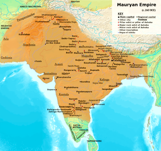
English: Maximum extent of the Maurya Empire, as shown by :-
Brief SummaryConquest of the Nanda EmpireHistorically reliable inscription details of Chandragupta's campaign against Nanda Empire are unavailable and but later written Buddhist, Jain, and Hindu texts which claim Magadha was ruled by the Nanda dynasty, which, with Chanakya's counsel, Chandragupta conquered Nanda Empire.[19][20][21] The army of Chandragupta and Chanakya first conquered the Nanda outer territories, and finally besieged the Nanda capital Pataliputra. In contrast to the easy victory in Buddhist sources, the Hindu and Jain texts state that the campaign was bitterly fought because the Nanda dynasty had a powerful and well-trained army.[22][20] Conquest of the Eastern Seleucid EmpireMegasthenes defined the region that Chandragupta won from Seleucus as likely western side Gedrosia which shares boundaries with the Euphrates River, and eastern side Arachosia shares boundaries with the Indus. The northern frontier boundary formed by Hindukush mountain range:

Greek historians mentioned the result of Seleucid–Mauryan war where Seleucid Empire's eastern satrapies( Gedrosia,Arachosia, Aria, and Paropamisadae) ceded to Mauryan Empire :
Greecian historian Pliny also quoted a passage from Megasthanes work about Chandragupta Empire boundaries:
Conquest of the AvantiAshoka served as a viceroy during the rule of his father Bindusara.According to established constitutional usage, Asoka as Prince served as viceroy in one of the remoter provinces of the Empire. This was the province of Western India called Avantirattham or province of Avanti with headquarter at Ujjain.[23] Conquest of the SaurashtraChandragupta conquered Southern-Western part of India. Especially his conquest over Saurashtra and Sudarshana lake construction is preseved in later Satrapian king Rudradaman inscription:
Conquest of the KalingaKalinga War plays a very important role in Mauryan history which changes a cruel Emperor Chanda-Ashoka to Priyadarshi Ashoka.
— Ashoka, Major Rock Edict No. 13 [6] Conquest of the KuntalaShikarpur Taluq, inscription 225 . Mentioned about Mauryan ruling in the region of Kuntala .The Kuntala country is an ancient Indian political region included the western Deccan and some parts of central,south Karnataka and north Mysore.
|
| Date | |
| Source | First I used User:Avantiputra7[9] map just for marking discovered Ashoka inscriptions exact location, User:Cattette File:The_Hellenistic_World_in_late_281_BC.png for Paropamisadai province location, later used Greecian texts Pliny and Strabo for northeastern boundaries after that I used en-wiki Stupas page[10] to mark Ashoka Stupas. Most of the stupas I marked by using British Historian Geoffrey Parker designed map on Mauryan Empire ,pg 29[11] .For empire exact extent toward north, east and south I used British historians Patrick K. O'Brien , Pg 46[12] , Charles Allen[13] and American historian Gerald Danzer designed Mauryan Empire map Pg 44[14]: |
| Author | Levakpitam |
![[9]](https://upload.wikimedia.org/wikipedia/commons/archive/2/2c/20150901144335%21Maurya_Empire%2C_c.250_BCE_2.png)
Licensing[edit]
- You are free:
- to share – to copy, distribute and transmit the work
- to remix – to adapt the work
- Under the following conditions:
- attribution – You must give appropriate credit, provide a link to the license, and indicate if changes were made. You may do so in any reasonable manner, but not in any way that suggests the licensor endorses you or your use.
- share alike – If you remix, transform, or build upon the material, you must distribute your contributions under the same or compatible license as the original.
References[edit]
- ↑
- ↑ https://books.google.nl/books?id=eyHTschgg50C&pg=PA178&redir_esc=y#v=onepage&q&f=false
- ↑ Shackley, Myra L.; Internet Archive (2006) , Amsterdam ; Boston : Elsevier ISBN: 978-0-7506-6348-9.
- ↑ https://archive.org/details/history-of-ancient-and-early-medeival-india-from-the-stone-age-to-the-12th-century-pdfdrive
- ↑ Spielvogel, Jackson J.; Internet Archive (2012) , Boston, MA : Wadsworth Cengage Learning ISBN: 978-0-495-91329-0.
- ↑ https://books.google.nl/books?id=cCdmEAAAQBAJ&pg=PT143&redir_esc=y#v=onepage&q&f=false
- ↑ ; Internet Archive (2002) , London : Times Books ISBN: 978-0-00-710859-6.
- ↑ Haywood, John; Internet Archive (1997) , New York : Barnes & Noble Books ISBN: 978-0-7607-0687-9.
- ↑ ; Internet Archive (1999) , The Softback Preview ISBN: 978-0-540-07858-5.
- ↑ https://books.google.nl/books?id=ffZy5tDjaUkC&pg=PA46&redir_esc=y#v=onepage&q&f=false
- ↑ https://www.routledge.com/India-The-Ancient-Past-A-History-of-the-Indian-Subcontinent-from-c-7000/Avari/p/book/9781138828216
- ↑ Cady, John F. (John Frank); Internet Archive (1964) , New York, McGraw-Hill
- ↑ Danzer, Gerald A.; Internet Archive (2000) , Ann Arbor, MI : Borders Press ISBN: 978-0-681-46572-5.
- ↑ Smith, Vincent Arthur ((Please provide a date)) The Oxford History of India: From the Earliest Times to the End of 1911Press, pages 104–106
- ↑ Rand McNally and Company; Internet Archive (1965) , Chicago
- ↑ ; Internet Archive (2008) , London : Times Books ISBN: 978-0-00-726731-6.
- ↑ An Advanced History of India& Company, (Please provide a date or year), page 104
- ↑ Schwartzberg, Joseph E. A Historical Atlas of South Asia , 2nd ed. (University of Minnesota, 1992), Plate III.B.4b (p.18) and Plate XIV.1a-c (p.145) |url=https://dsal.uchicago.edu/reference/schwartzberg/ |date=26 January 2021
- ↑ Thapar, 2013, pp. 362–364
- ↑ a b Sen, 1895, pp. 26–32
- ↑ Upinder Singh, 2008, p. 272
- ↑ Mookerji, 1988, pp. 28–33
- ↑ Mookerji, Radhakumud (1962) (in English) Asoka, Motilal Banarsidass Publishe ISBN: 978-81-208-0582-8.
- ↑ "Junagadh Rock Inscription of Rudradaman", Project South Asia.Archived 23 February 2009 at the Wayback Machine
File history
Click on a date/time to view the file as it appeared at that time.
| Date/Time | Thumbnail | Dimensions | User | Comment | |
|---|---|---|---|---|---|
| current | 14:58, 3 December 2023 | | 2,400 × 2,242 (2.41 MB) | Levakpitam (talk | contribs) | more clear & readable . |
| 18:03, 1 December 2023 |  | 1,200 × 1,121 (1.84 MB) | Levakpitam (talk | contribs) | Uploaded own work with UploadWizard |
You cannot overwrite this file.
File usage on Commons
The following page uses this file:
File usage on other wikis
The following other wikis use this file:
- Usage on bh.wikipedia.org
- Usage on bn.wikipedia.org
- Usage on es.wikipedia.org
- Usage on hi.wikipedia.org
- Usage on ne.wikipedia.org
- Usage on si.wikipedia.org
- Usage on te.wikipedia.org