File:TurksInBGPercent2011.svg
Jump to navigation
Jump to search

Size of this PNG preview of this SVG file: 800 × 506 pixels. Other resolutions: 320 × 202 pixels | 640 × 405 pixels | 1,024 × 648 pixels | 1,280 × 810 pixels | 2,560 × 1,619 pixels | 1,652 × 1,045 pixels.
Original file (SVG file, nominally 1,652 × 1,045 pixels, file size: 1.35 MB)
Captions
Captions
Add a one-line explanation of what this file represents
Summary[edit]
| Description |
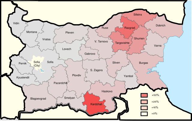
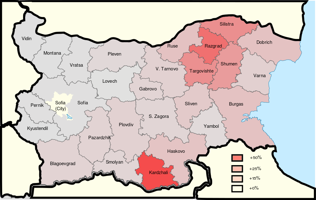
English: Percentage of the Turkish population to total local population in every province of Bulgaria. |
| Date | |
| Source | Own work |
| Author | Infestor |
This W3C-unspecified vector image was created with Inkscape .
Licensing[edit]
I, the copyright holder of this work, hereby publish it under the following license:
This file is licensed under the Creative Commons Attribution-Share Alike 3.0 Unported license.
- You are free:
- to share – to copy, distribute and transmit the work
- to remix – to adapt the work
- Under the following conditions:
- attribution – You must give appropriate credit, provide a link to the license, and indicate if changes were made. You may do so in any reasonable manner, but not in any way that suggests the licensor endorses you or your use.
- share alike – If you remix, transform, or build upon the material, you must distribute your contributions under the same or compatible license as the original.
File history
Click on a date/time to view the file as it appeared at that time.
| Date/Time | Thumbnail | Dimensions | User | Comment | |
|---|---|---|---|---|---|
| current | 21:52, 9 April 2016 | | 1,652 × 1,045 (1.35 MB) | Infestor (talk | contribs) | Reverted to version as of 15:25, 26 August 2012 (UTC) |
| 03:41, 9 April 2016 |  | 884 × 606 (264 KB) | The pacific ocean (talk | contribs) | Reverted to version as of 12:34, 26 August 2015 (UTC) definitions are unclear, at the map there are more colors than the legend | |
| 20:28, 31 March 2016 |  | 1,652 × 1,045 (1.35 MB) | PlatonPskov (talk | contribs) | Reverted to version as of 15:25, 26 August 2012 (UTC) | |
| 12:34, 26 August 2015 |  | 884 × 606 (264 KB) | The pacific ocean (talk | contribs) | detailed map | |
| 15:25, 26 August 2012 |  | 1,652 × 1,045 (1.35 MB) | Infestor (talk | contribs) | User created page with UploadWizard |
You cannot overwrite this file.
File usage on Commons
The following 2 pages use this file:
File usage on other wikis
The following other wikis use this file:
- Usage on ar.wikipedia.org
- Usage on az.wikipedia.org
- Usage on be.wikipedia.org
- Usage on bg.wikipedia.org
- Usage on de.wikipedia.org
- Usage on en.wikipedia.org
- Usage on fa.wikipedia.org
- Usage on fi.wikipedia.org
- Usage on hy.wikipedia.org
- Usage on lv.wikipedia.org
- Usage on pl.wikipedia.org
- Usage on pnb.wikipedia.org
- Usage on rm.wikipedia.org
- Usage on ro.wikipedia.org
- Usage on ru.wikipedia.org
- Usage on tr.wikipedia.org
- Usage on ur.wikipedia.org