File:Tropospheric profile Uranus ru.png
Jump to navigation
Jump to search

Size of this preview: 800 × 562 pixels. Other resolutions: 320 × 225 pixels | 640 × 450 pixels | 1,024 × 719 pixels | 1,280 × 899 pixels | 2,560 × 1,798 pixels | 2,970 × 2,086 pixels.
Original file (2,970 × 2,086 pixels, file size: 78 KB, MIME type: image/png)
Captions
Captions
Add a one-line explanation of what this file represents
| Description |
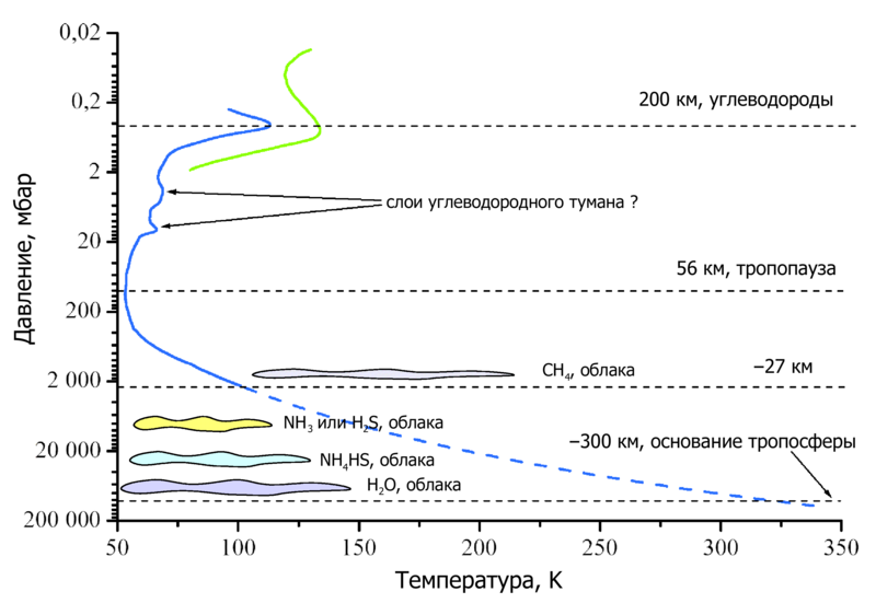
English: This graph shows temperature profile in the en:troposphere and in the lower en:stratosphere of en:Uranus. Heights are also indicated.
Русский: На схеме показан температурный профиль тропосферы и нижней стратосферы Урана.
Примечания
|
||
| Date | |||
| Source | Translation of File:Tropospheric profile Uranus.png | ||
| Author |
Illustration by: Ruslik0 Translation by: Minami Himemiya |
||
| Permission (Reusing this file) |
|
||
| Other versions |

File history
Click on a date/time to view the file as it appeared at that time.
| Date/Time | Thumbnail | Dimensions | User | Comment | |
|---|---|---|---|---|---|
| current | 16:29, 6 November 2021 | | 2,970 × 2,086 (78 KB) | Mikhail Ryazanov (talk | contribs) | |
| 14:42, 27 December 2008 |  | 2,970 × 2,086 (86 KB) | 姫宮南 (talk | contribs) | {{Information |Description={{en|This graph shows temperature profile in the en:troposphere and in the lower en:stratosphere of en:Uranus. Heights are also indicated. *The '''blue''' curve is from Lindal ''et al.''<ref name=Lindal1987/> *T |
You cannot overwrite this file.
File usage on Commons
There are no pages that use this file.
File usage on other wikis
The following other wikis use this file:
- Usage on be.wikipedia.org
- Usage on ru.wikipedia.org