File:Polish-Lithuanian Commonwealth (Polonia) (1770) (2).jpg
Jump to navigation
Jump to search

Size of this preview: 774 × 600 pixels. Other resolutions: 310 × 240 pixels | 620 × 480 pixels | 991 × 768 pixels | 1,280 × 992 pixels | 2,560 × 1,983 pixels | 6,862 × 5,316 pixels.
Original file (6,862 × 5,316 pixels, file size: 9.44 MB, MIME type: image/jpeg)
Captions
Captions
Add a one-line explanation of what this file represents
Summary[edit]
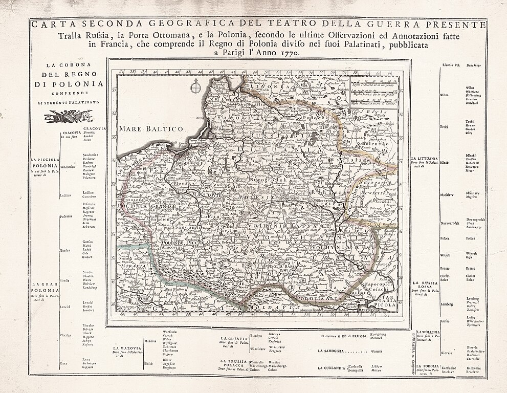
| Description |
Беларуская (тарашкевіца): Мапа Рэчы Паспалітай (у тагачаснай палітычнай тэрміналёгіі «Польшчы», Polonia) |
| Date | |
| Source | Carta seconda geografica del teatro della guerra presente Tralla Russia, la Porta Ottomana, e la Polonia, secondo le ultime osservazioni et annotiazioni fatte in Francia, che comprende il Regno di Polonia difiso nei fuoi palatinati |
| Author | Unknown author |
| Other versions |
|
_(1770).jpg)
_(I._Tirion,_1733).jpg)
_(G._Albrizzi,_I._Tirion,_1740).jpg)
_(1770)_(2).jpg&action=edit§ion=1)
Licensing[edit]
_(1770)_(2).jpg&action=edit§ion=2)
|
This work is in the public domain in its country of origin and other countries and areas where the copyright term is the author's life plus 100 years or fewer. | |
| This file has been identified as being free of known restrictions under copyright law, including all related and neighboring rights. | |
File history
Click on a date/time to view the file as it appeared at that time.
| Date/Time | Thumbnail | Dimensions | User | Comment | |
|---|---|---|---|---|---|
| current | 15:46, 30 August 2022 | | 6,862 × 5,316 (9.44 MB) | Kazimier Lachnovič (talk | contribs) | == {{int:filedesc}} == {{Information |Description ={{be-tarask|1=Мапа Рэчы Паспалітай (у тагачаснай палітычнай тэрміналёгіі «Польшчы», ''Polonia'')}} |Source =Carta seconda geografica del teatro della guerra presente Tralla Russia, la Porta Ottomana, e la Polonia, secondo le ultime osservazioni et annotiazioni fatte in Francia, che comprende il Regno di Polonia difiso nei fuoi palatinati |Author ={{unknown|author}} |Date =1770 |other_vers... |
You cannot overwrite this file.
File usage on Commons
The following page uses this file:
File usage on other wikis
The following other wikis use this file:
- Usage on be-tarask.wikipedia.org
_(1770)_(2).jpg&oldid=692838546)