File:Map of federal states.svg
Jump to navigation
Jump to search

Size of this PNG preview of this SVG file: 800 × 411 pixels. Other resolutions: 320 × 164 pixels | 640 × 329 pixels | 1,024 × 526 pixels | 1,280 × 657 pixels | 2,560 × 1,314 pixels | 863 × 443 pixels.
Original file (SVG file, nominally 863 × 443 pixels, file size: 1.48 MB)
Captions
Captions
Add a one-line explanation of what this file represents
Summary[edit]
| Description |
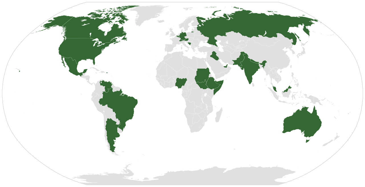
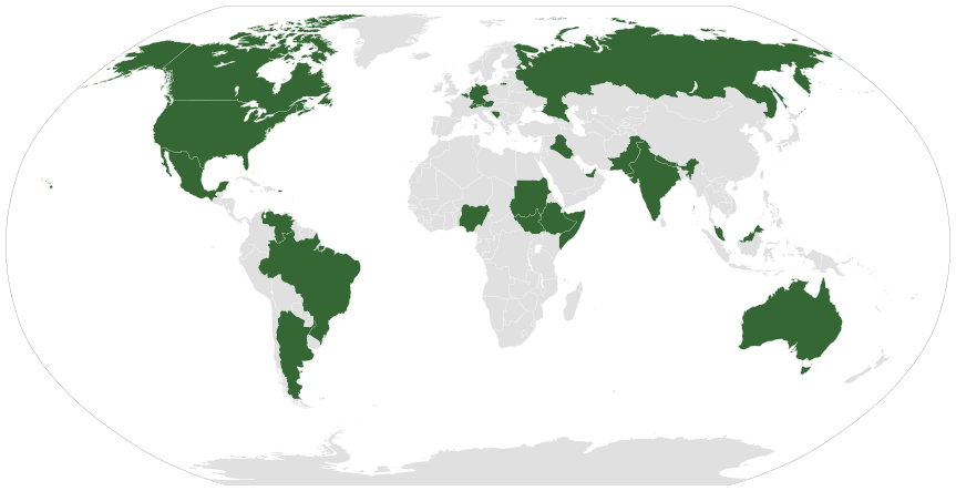
English: A map displaying today's federations.
Italiano: Una mappa mostrante le federazioni di oggi.
Русский: Современные федеративные государства на карте мира
Vèneto: Na mapa che mosa le federazion de incoi.
Español: Un mapa que muestra las federaciones que existen hoy.
Português: Um mapa que mostra as federações de hoje em dia.
Deutsch: Eine Weltkarte mit Hervorhebung aller föderaler Staaten. |
| Date | |
| Source | Own work (Original text: Own work based on: File:BlankMap-World6.svg and the list in en:Federation#Contemporary. Coloured similar to File:Federal states.png) |
| Author | Lokal_Profil |
| Other versions | File:Map of unitary states.svg and File:Map of unitary and federal states.svg |
| SVG development |
Licensing[edit]
This file is licensed under the Creative Commons Attribution-Share Alike 2.5 Generic license.
Attribution: Lokal_Profil
- You are free:
- to share – to copy, distribute and transmit the work
- to remix – to adapt the work
- Under the following conditions:
- attribution – You must give appropriate credit, provide a link to the license, and indicate if changes were made. You may do so in any reasonable manner, but not in any way that suggests the licensor endorses you or your use.
- share alike – If you remix, transform, or build upon the material, you must distribute your contributions under the same or compatible license as the original.
File history
Click on a date/time to view the file as it appeared at that time.
| Date/Time | Thumbnail | Dimensions | User | Comment | |
|---|---|---|---|---|---|
| current | 12:43, 3 January 2023 | | 863 × 443 (1.48 MB) | Maphobbyist (talk | contribs) | Iraq and the United Arab Emirates are federal states. |
| 19:04, 21 September 2022 |  | 863 × 443 (1.48 MB) | Salma3232 (talk | contribs) | Reverted to version as of 03:24, 1 August 2021 (UTC) | |
| 12:00, 3 August 2021 |  | 863 × 443 (1.45 MB) | Siirski (talk | contribs) | Added Somaliland | |
| 03:24, 1 August 2021 |  | 863 × 443 (1.48 MB) | Waberi4291 (talk | contribs) | Reverted to version as of 05:02, 8 September 2013 (UTC) | |
| 05:05, 8 September 2013 |  | 863 × 443 (1.48 MB) | EmmaCoop (talk | contribs) | Forgot Iraq | |
| 05:02, 8 September 2013 |  | 863 × 443 (1.48 MB) | EmmaCoop (talk | contribs) | Divided Sudan and South Sudan (became a state in 2011). | |
| 21:02, 26 September 2012 |  | 940 × 477 (1.65 MB) | Middayexpress (talk | contribs) | added Federal Republic of Somalia | |
| 17:29, 16 August 2008 |  | 940 × 477 (1.65 MB) | Jeroen (talk | contribs) | removed kingdom of the netherlands - see talk | |
| 00:18, 26 September 2007 |  | 940 × 477 (1.56 MB) | Lokal Profil (talk | contribs) | Less broken code and corrected metadata | |
| 01:34, 14 September 2007 |  | 940 × 477 (1.56 MB) | Lokal Profil (talk | contribs) | Readded netherlands, aruba and netherlands antilles. See comment |
You cannot overwrite this file.
File usage on Commons
The following 7 pages use this file:
.svg)
File usage on other wikis
The following other wikis use this file:
- Usage on af.wikipedia.org
- Usage on als.wikipedia.org
- Usage on an.wikipedia.org
- Usage on ar.wikipedia.org
- Usage on arz.wikipedia.org
- Usage on ast.wikipedia.org
- Usage on azb.wikipedia.org
- Usage on az.wikipedia.org
- Usage on az.wiktionary.org
- Usage on ba.wikipedia.org
- Usage on be-tarask.wikipedia.org
- Usage on be.wikipedia.org
- Usage on bg.wikipedia.org
- Usage on br.wikipedia.org
- Usage on bs.wikipedia.org
- Usage on ca.wikipedia.org
- Usage on ckb.wikipedia.org
- Usage on co.wikipedia.org
- Usage on cs.wikipedia.org
- Usage on cy.wikipedia.org
- Usage on de.wikipedia.org
- Usage on de.wiktionary.org
- Usage on diq.wikipedia.org
- Usage on el.wiktionary.org
- Usage on en.wikipedia.org
- Usage on eo.wikipedia.org
- Usage on es.wikipedia.org
- Usage on eu.wikipedia.org
- Usage on fa.wikipedia.org
- Usage on fi.wikipedia.org
View more global usage of this file.