File:Aerial View of Damavand 26.11.2008 04-25-38.JPG
Jump to navigation
Jump to search

Size of this preview: 800 × 600 pixels. Other resolutions: 320 × 240 pixels | 640 × 480 pixels | 1,024 × 768 pixels | 1,280 × 960 pixels | 2,048 × 1,536 pixels.
Original file (2,048 × 1,536 pixels, file size: 1.79 MB, MIME type: image/jpeg)
Captions
Captions
Add a one-line explanation of what this file represents
Summary[edit]
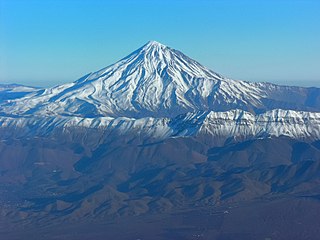
| Description | Aerial View of Damavand |
| Date | Taken on 26 November 2008, 04:25:38 |
| Source | Own work |
| Author | Hansueli Krapf |
| Permission (Reusing this file) |
Attribution ShareAlike 3.0 |
| Camera location | | View this and other nearby images on: OpenStreetMap |
|---|
| Annotations | This image is annotated: View the annotations at Commons |
Licensing[edit]
This file is licensed under the Creative Commons Attribution-Share Alike 3.0 Unported license.
- You are free:
- to share – to copy, distribute and transmit the work
- to remix – to adapt the work
- Under the following conditions:
- attribution – You must give appropriate credit, provide a link to the license, and indicate if changes were made. You may do so in any reasonable manner, but not in any way that suggests the licensor endorses you or your use.
- share alike – If you remix, transform, or build upon the material, you must distribute your contributions under the same or compatible license as the original.
File history
Click on a date/time to view the file as it appeared at that time.
| Date/Time | Thumbnail | Dimensions | User | Comment | |
|---|---|---|---|---|---|
| current | 15:50, 29 December 2012 | | 2,048 × 1,536 (1.79 MB) | Simisa (talk | contribs) | Changed color temperature |
| 19:47, 19 June 2009 |  | 2,048 × 1,536 (928 KB) | Simisa (talk | contribs) | {{Information |Description=Aerial View of Damavand |Source=Own Work |Date=see metadata |Author=Hansueli Krapf |Permission=Attribution ShareAlike 3.0 |other_versions= }} {{cc-by-sa-3.0}} Category:Aerial photographs of Iran [[Category: |
You cannot overwrite this file.
File usage on Commons
The following page uses this file:
File usage on other wikis
The following other wikis use this file:
- Usage on ar.wikipedia.org
- مازندران (محافظة)
- ساري
- نوشهر
- كلاردشت
- جبل دماوند
- بابل (إيران)
- أمل (مازندران)
- جويبار
- شالوس
- رامسر
- بابلسر
- بهشهر
- قائم شهر
- قالب:محافظة مازندران
- نيما يوشيج
- جسر ورسك
- مقاطعة عباس آباد (مازندران)
- عباس آباد (مازندران)
- كلار آباد (مازندران)
- سلمان شهر (مازندران)
- مقاطعة أمل
- مقاطعة بابلسر (مازندران)
- مقاطعة بهشهر
- مقاطعة شالوس
- مقاطعة فريدونكنار (مازندران)
- مقاطعة غلوغاه (مازندران)
- مقاطعة جويبار (مازندران)
- مقاطعة محمود آباد (مازندران)
- مقاطعة مياندورود (مازندران)
- مقاطعة نكا (مازندران)
- مقاطعة نوشهر
- مقاطعة نور
- مقاطعة قائم شهر
- مقاطعة رامسر
- مقاطعة ساري
- مقاطعة سواد كوه
- مقاطعة تنكابن (مازندران)
- تنكابن
- نور (إيران)
- محمود أباد
- رويان (إيران)
- ألشت
- شيرغاه
- تشمستان
- فريدونكنار
- كوهي خيل
- رستمكلا
- زيرأب
- بهنمير
- بلده (إيران)
View more global usage of this file.