File:Europe-Isle of Man.svg
Jump to navigation
Jump to search

Size of this PNG preview of this SVG file: 713 × 600 pixels. Other resolutions: 285 × 240 pixels | 571 × 480 pixels | 913 × 768 pixels | 1,218 × 1,024 pixels | 2,435 × 2,048 pixels | 2,045 × 1,720 pixels.
Original file (SVG file, nominally 2,045 × 1,720 pixels, file size: 2.24 MB)
Captions
Captions
Add a one-line explanation of what this file represents
Summary[edit]
| Description |
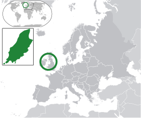
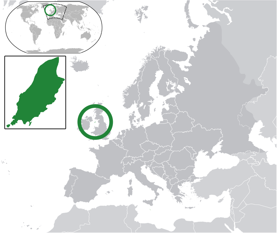
English:
Map in English of the Isle of Man, with bounds of sheadings, towns, villages, districts and parishes. (Green) Isle of Man.
(Gray) Europe.
(Light-gray) The surrounding region.
The Full Map of the Isle of Man |
||
| Date | |||
| Source | Own work based on: IsleOfMan SheadingsAndParishes-en.svg | ||
| Author | Chipmunkdavis | ||
| Permission (Reusing this file) |
This file is licensed under the Creative Commons Attribution-Share Alike 3.0 Unported license.
|
||
| SVG development |
|
Original upload log[edit]
This image is a derivative work of the following images:
- licensed with Cc-by-sa-3.0
- 2011-02-21T07:49:57Z Chipmunkdavis 2045x1720 (2394864 Bytes)
- IsleOfMan SheadingsAndParishes-en.svg licensed with Cc-by-sa-3.0,2.5,2.0,1.0, GFDL
- 2008-01-17T12:48:28Z Sémhur 1200x1100 (227618 Bytes) Update
- 2007-05-29T20:36:04Z Sémhur 0x0 (364350 Bytes) {{Information |Description=Map in English of the [[:en:Isle of Man|Isle of Man]], with bounds of sheadings, towns, villages, districts and parishes. |Source=Own work. Based on maps [[:Image:Isle of Man map-fr.svg]], [[:Image:
Uploaded with derivativeFX
File history
Click on a date/time to view the file as it appeared at that time.
| Date/Time | Thumbnail | Dimensions | User | Comment | |
|---|---|---|---|---|---|
| current | 06:10, 2 March 2011 | | 2,045 × 1,720 (2.24 MB) | Chipmunkdavis (talk | contribs) | Redid inset |
| 06:03, 2 March 2011 |  | 2,045 × 1,720 (2.22 MB) | Chipmunkdavis (talk | contribs) | Without inset | |
| 06:01, 2 March 2011 |  | 2,045 × 1,720 (2.22 MB) | Chipmunkdavis (talk | contribs) | One more try | |
| 09:03, 21 February 2011 |  | 2,045 × 1,720 (2.22 MB) | Chipmunkdavis (talk | contribs) | Grouped inset | |
| 09:00, 21 February 2011 |  | 2,045 × 1,720 (2.22 MB) | Chipmunkdavis (talk | contribs) | File not appearing properly, reuploading | |
| 08:06, 21 February 2011 |  | 2,045 × 1,720 (2.22 MB) | Chipmunkdavis (talk | contribs) | {{Information |Description={{en|1={{Europe-SVG-en|Northern Cyprus}}}} {{en|1=The Full Map of Jersey}} Map in english of the Isle of Man, with bounds of sheadings, towns, villages, districts and parishes. |Source=*[[:File:Europe-Jersey. |
You cannot overwrite this file.
File usage on Commons
More than 100 pages use this file. The following list shows the first 100 pages that use this file only. A full list is available.
- Category:1919 in the Isle of Man
- Category:1961 in the Isle of Man
- Category:1962 in the Isle of Man
- Category:1965 in the Isle of Man
- Category:1969 in the Isle of Man
- Category:1971 in the Isle of Man
- Category:1972 in the Isle of Man
- Category:1973 in the Isle of Man
- Category:1978 in the Isle of Man
- Category:1979 in the Isle of Man
- Category:1989 in the Isle of Man
- Category:1990 in the Isle of Man
- Category:1991 in the Isle of Man
- Category:1992 in the Isle of Man
- Category:1993 in the Isle of Man
- Category:1995 in the Isle of Man
- Category:1999 in the Isle of Man
- Category:2000 in the Isle of Man
- Category:2001 in the Isle of Man
- Category:2003 in the Isle of Man
- Category:2004 in the Isle of Man
- Category:2005 in the Isle of Man
- Category:2006 in the Isle of Man
- Category:2007 in the Isle of Man
- Category:2008 in the Isle of Man
- Category:2009 in the Isle of Man
- Category:2010 in the Isle of Man
- Category:2011 in the Isle of Man
- Category:2012 in the Isle of Man
- Category:2013 in the Isle of Man
- Category:2014 in the Isle of Man
- Category:2015 in the Isle of Man
- Category:2016 in the Isle of Man
- Category:2017 in the Isle of Man
- Category:2018 in the Isle of Man
- Category:Agriculture in the Isle of Man
- Category:Airports in the Isle of Man
- Category:Animals of the Isle of Man
- Category:Archaeological sites in the Isle of Man
- Category:Association football players from the Isle of Man
- Category:Aviation in the Isle of Man
- Category:Bays of the Isle of Man
- Category:Bodies of water in the Isle of Man
- Category:Buildings in the Isle of Man
- Category:Castles in the Isle of Man
- Category:Churches in the Isle of Man
- Category:Cricket in the Isle of Man
- Category:Cycling in the Isle of Man
- Category:Cyclists from the Isle of Man
- Category:Events in the Isle of Man
- Category:Geology of the Isle of Man
- Category:Governors of the Isle of Man
- Category:Headlands of the Isle of Man
- Category:Hill forts in the Isle of Man
- Category:Historic sites in the Isle of Man
- Category:History of transport in the Isle of Man
- Category:Horse-drawn trams in the Isle of Man
- Category:Hospitals on the Isle of Man
- Category:Industry in the Isle of Man
- Category:Infrastructure in the Isle of Man
- Category:Islands of the Isle of Man
- Category:Isle of Man
- Category:Isle of Man by year
- Category:Isle of Man in the 1890s
- Category:Isle of Man in the 1900s
- Category:Isle of Man in the 1910s
- Category:Isle of Man in the 1960s
- Category:Isle of Man in the 1970s
- Category:Isle of Man in the 1980s
- Category:Isle of Man in the 1990s
- Category:Isle of Man in the 2000s
- Category:Isle of Man in the 2010s
- Category:Landforms of the Isle of Man
- Category:Lighthouses in the Isle of Man
- Category:Men of the Isle of Man
- Category:Mines in the Isle of Man
- Category:Motorsports in the Isle of Man
- Category:Museums in the Isle of Man
- Category:Passenger ships of the Isle of Man
- Category:People of the Isle of Man by city
- Category:Politicians of the Isle of Man
- Category:Populated places in the Isle of Man
- Category:Racing circuits in the Isle of Man
- Category:Rail transport infrastructure in the Isle of Man
- Category:Railway stations in the Isle of Man
- Category:Rivers of the Isle of Man
- Category:Road transport in the Isle of Man
- Category:Roads in the Isle of Man
- Category:Roman Catholic churches in the Isle of Man
- Category:Schools in the Isle of Man
- Category:Ships of the Isle of Man
- Category:Society of the Isle of Man
- Category:Sports venues in the Isle of Man
- Category:Theatres in the Isle of Man
- Category:Towers in the Isle of Man
- Category:Trains of the Isle of Man
- Category:Transport infrastructure in the Isle of Man
- Category:Visitor attractions in the Isle of Man
- Category:Water transport in the Isle of Man
- Category:Water wheels in the Isle of Man
View more links to this file.
File usage on other wikis
The following other wikis use this file:
- Usage on ace.wikipedia.org
- Usage on an.wikipedia.org
- Usage on ar.wikipedia.org
- Usage on arz.wikipedia.org
- Usage on ast.wikipedia.org
- Usage on az.wikipedia.org
- Usage on ba.wikipedia.org
- Usage on bg.wikipedia.org
- Usage on bh.wikipedia.org
- Usage on bn.wikipedia.org
- Usage on ca.wikipedia.org
- Usage on cdo.wikipedia.org
- Usage on cs.wikipedia.org
- Usage on diq.wikipedia.org
- Usage on en.wikipedia.org
- Usage on eo.wikipedia.org
- Usage on es.wikipedia.org
- Usage on ext.wikipedia.org
- Usage on fi.wiktionary.org
- Usage on fr.wikipedia.org
- Usage on ga.wikipedia.org
- Usage on gl.wikipedia.org
- Usage on hak.wikipedia.org
- Usage on ha.wikipedia.org
- Usage on he.wikipedia.org
- Usage on ia.wikipedia.org
- Usage on incubator.wikimedia.org
- Usage on it.wikipedia.org
- Usage on ja.wikipedia.org
- Usage on kab.wikipedia.org
- Usage on kk.wikipedia.org
- Usage on km.wikipedia.org
- Usage on la.wikipedia.org
- Usage on lb.wikipedia.org
- Usage on lij.wikipedia.org
- Usage on lv.wikipedia.org
- Usage on mk.wikipedia.org
View more global usage of this file.