File:U.S. Territorial Acquisitions.ar.png
Jump to navigation
Jump to search

Size of this preview: 800 × 541 pixels. Other resolutions: 320 × 216 pixels | 640 × 433 pixels | 1,024 × 692 pixels | 1,280 × 865 pixels | 1,536 × 1,038 pixels.
Original file (1,536 × 1,038 pixels, file size: 922 KB, MIME type: image/png)
Captions
Captions
Add a one-line explanation of what this file represents
Summary[edit]
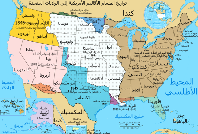
| Description | This image depicts the Territorial acquisitions of the United States, such as the Thirteen Colonies, the Louisiana Purchase, British and Spanish Cession, and so on. === Possible Errors === There is a concern that this map could have errors. For discussion, please see the talk page. |
| Date | (UTC) |
| Source |
This file was derived from: U.S. Territorial Acquisitions.png: |
| Author |
|
| This is a retouched picture, which means that it has been digitally altered from its original version. Modifications: translated to arabic. The original can be viewed here: U.S. Territorial Acquisitions.png:
|
Licensing[edit]
This map was obtained from an edition of the National Atlas of the United States. Like almost all works of the U.S. federal government, works from the National Atlas are in the public domain in the United States.
Online access: NationalAtlas.gov | 1970 print edition: Library of Congress, Perry-Castañeda Library
|
Original upload log[edit]
This image is a derivative work of the following images:
- File:U.S._Territorial_Acquisitions.png licensed with PD-USGov-Atlas
- 2006-09-16T15:36:22Z Shizhao 1536x1038 (1164091 Bytes) {{Information| |Description= United States Territorial Acquisitions == Summary == {{main|United States territorial acquisitions}} This image depicts the United States' historic acquisitions of territories, such as the Thirte
Uploaded with derivativeFX
File history
Click on a date/time to view the file as it appeared at that time.
| Date/Time | Thumbnail | Dimensions | User | Comment | |
|---|---|---|---|---|---|
| current | 19:53, 14 February 2012 | | 1,536 × 1,038 (922 KB) | باسم (talk | contribs) | == {{int:filedesc}} == {{Information |Description=This image depicts the Territorial acquisitions of the United States, such as the Thirteen Colonies, the Louisiana Purchase, British and Spanish Cessio |
You cannot overwrite this file.
File usage on Commons
There are no pages that use this file.
File usage on other wikis
The following other wikis use this file:
- Usage on ar.wikipedia.org