File:Tehran Night Panorama.jpg
Jump to navigation
Jump to search
Size of this preview: 800 × 122 pixels. Other resolutions: 320 × 49 pixels | 640 × 97 pixels | 4,603 × 700 pixels.
Original file (4,603 × 700 pixels, file size: 470 KB, MIME type: image/jpeg)
Captions
Captions
Add a one-line explanation of what this file represents
Summary[edit]
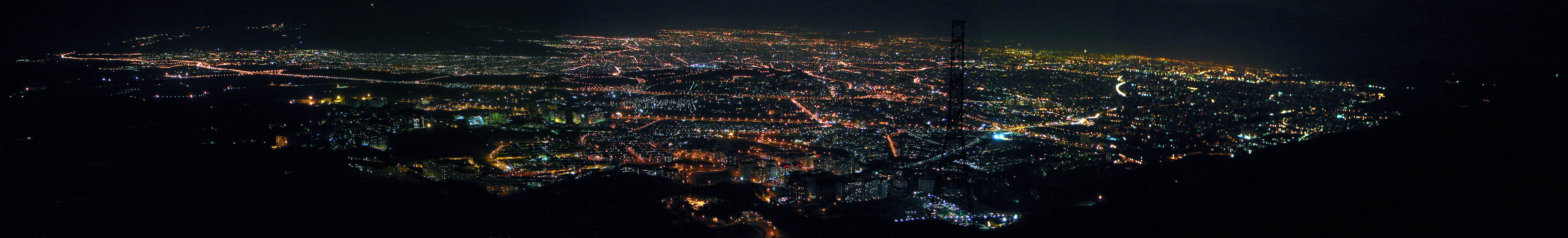
| Description | Tehran, Iran. Generated from 7 shots. Tehran is one of the biggest cities all over the world, it is 250km from east to west and 50 km from north to south! |
| Date | |
| Source | Tehran Night Panorama |
| Author | Hamed Saber from Tehran, Iran |
| Camera location | | View this and other nearby images on: OpenStreetMap |
|---|
Licensing[edit]
This file is licensed under the Creative Commons Attribution 2.0 Generic license.
- You are free:
- to share – to copy, distribute and transmit the work
- to remix – to adapt the work
- Under the following conditions:
- attribution – You must give appropriate credit, provide a link to the license, and indicate if changes were made. You may do so in any reasonable manner, but not in any way that suggests the licensor endorses you or your use.
| This image was originally posted to Flickr by Hamed Saber at https://www.flickr.com/photos/44124425616@N01/139592515. It was reviewed on 5 February 2008 by FlickreviewR and was confirmed to be licensed under the terms of the cc-by-2.0. |
File history
Click on a date/time to view the file as it appeared at that time.
| Date/Time | Thumbnail | Dimensions | User | Comment | |
|---|---|---|---|---|---|
| current | 19:25, 28 January 2008 | 4,603 × 700 (470 KB) | Jacoplane (talk | contribs) | {{Information |Description= Breaking news! (2006/07/08): '' With my new pro account, I replaced the panorama with a larger size. (Not the original, but a bigger one. Although this is my first panorama try and has too many problems!) You can view the detai |
You cannot overwrite this file.
File usage on Commons
The following page uses this file:
File usage on other wikis
The following other wikis use this file:
- Usage on ar.wikipedia.org
- Usage on av.wikipedia.org
- Usage on azb.wikipedia.org
- Usage on az.wiktionary.org
- Usage on bg.wikipedia.org
- Usage on bn.wikipedia.org
- Usage on ca.wikipedia.org
- Usage on cs.wikipedia.org
- Usage on en.wikipedia.org
- Usage on eo.wikipedia.org
- Usage on eu.wikipedia.org
- Usage on fa.wikipedia.org
- Usage on hi.wikipedia.org
- Usage on hr.wikipedia.org
- Usage on it.wikipedia.org
- Usage on ja.wikipedia.org
- Usage on kk.wikipedia.org
- Usage on kn.wikipedia.org
- Usage on ko.wikipedia.org
- Usage on nl.wikipedia.org
- Usage on roa-tara.wikipedia.org
- Usage on sh.wikipedia.org
- Usage on sr.wikipedia.org
- Usage on te.wikipedia.org
- Usage on th.wikipedia.org
- Usage on uk.wikipedia.org
- Usage on uz.wikipedia.org
- Usage on vi.wikipedia.org
- Usage on yi.wikipedia.org
- Usage on zh.wikipedia.org