File:OttomanEmpireIn1683 ar.png
Jump to navigation
Jump to search
Size of this preview: 637 × 599 pixels. Other resolutions: 255 × 240 pixels | 510 × 480 pixels | 816 × 768 pixels | 1,088 × 1,024 pixels | 1,966 × 1,850 pixels.
Original file (1,966 × 1,850 pixels, file size: 379 KB, MIME type: image/png)
Captions
Captions
Add a one-line explanation of what this file represents

|
This map image could be re-created using vector graphics as an SVG file. This has several advantages; see Commons:Media for cleanup for more information. If an SVG form of this image is available, please upload it and afterwards replace this template with
{{vector version available|new image name}}.
It is recommended to name the SVG file “OttomanEmpireIn1683 ar.svg”—then the template Vector version available (or Vva) does not need the new image name parameter. |
| Description |
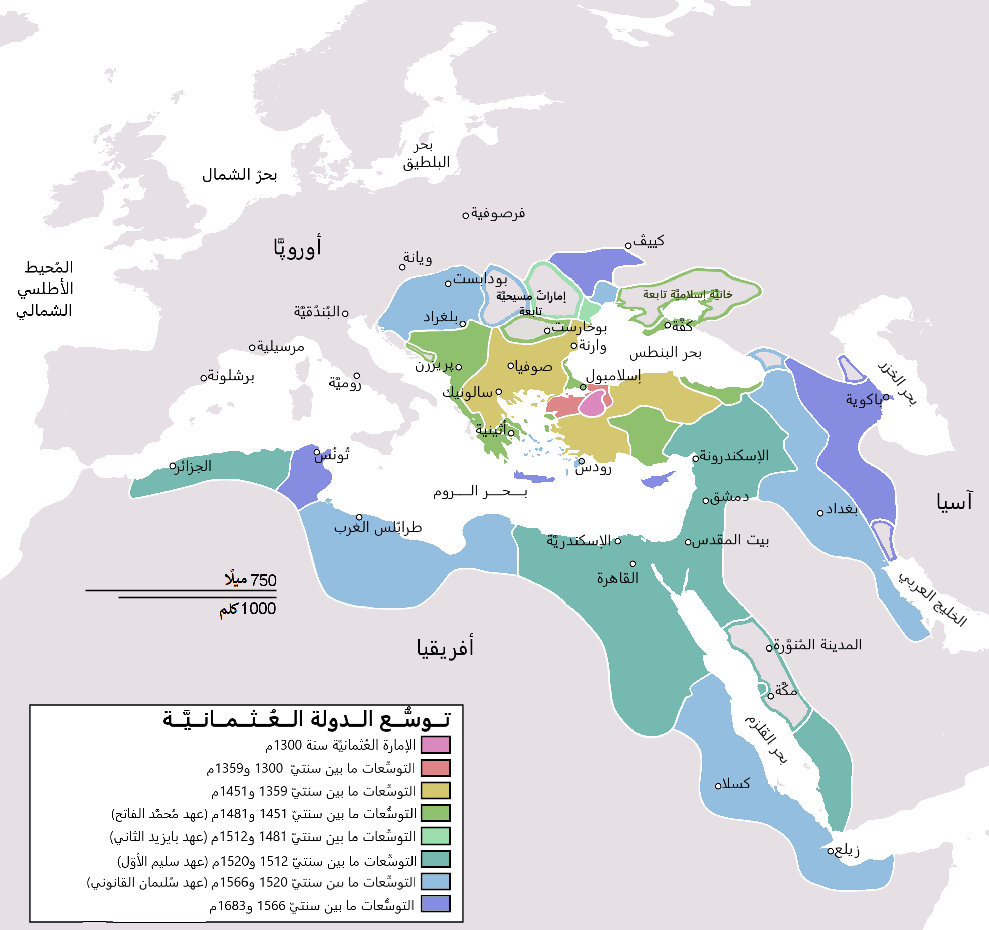
English: Map depicting the Ottoman Empire at its greatest extent, in 1683. Türkçe: Osmanlı İmparatorluğu en geniş sınırları (1683) |
| Date | (UTC) |
| Source | |
| Author |
|
| Other versions |
[]
|


| This is a retouched picture, which means that it has been digitally altered from its original version. Modifications: translated to arabic. The original can be viewed here: OttomanEmpireIn1683.png:
|
I, the copyright holder of this work, hereby publish it under the following license:
| I, the copyright holder of this work, release this work into the public domain. This applies worldwide. In some countries this may not be legally possible; if so: I grant anyone the right to use this work for any purpose, without any conditions, unless such conditions are required by law. |
Original upload log[edit]
This image is a derivative work of the following images:
- File:OttomanEmpireIn1683.png licensed with PD-self
- 2010-12-10T23:11:12Z Lambiam 1966x1850 (347599 Bytes) Scale indicator more up to actual scale
- 2010-11-16T18:53:38Z Hamelin de Guettelet 1966x1850 (375469 Bytes) {{Information |Description= Rhodes et autres îles ne sont prises aux Hospitaliers que le 1 janvier 1523 |Source={{own}} |Date=16 novembre 2010 |Author=[[User:Hamelin de Guettelet|Hamelin de Guettelet]] |Permission= |other_ve
- 2010-04-01T10:40:16Z Nedim Ardoğa 1966x1850 (334406 Bytes) Reverted to version as of 07:37, 10 March 2010
- 2010-03-31T12:11:05Z Bahramm 2 637x599 (168664 Bytes) Reverted to version as of 14:12, 1 March 2010
- 2010-03-10T07:37:04Z Nedim Ardoğa 1966x1850 (334406 Bytes) Reverted to version as of 20:35, 21 February 2010
- 2010-03-01T14:12:01Z Bahramm 2 637x599 (168664 Bytes) Reverted to version as of 18:51, 24 January 2010
- 2010-02-21T20:35:06Z Nedim Ardoğa 1966x1850 (334406 Bytes) Reverted to version as of 15:12, 26 March 2007
- 2010-01-24T18:51:26Z Persia2099 637x599 (168664 Bytes) Minor Update
- 2007-03-26T15:12:25Z AtilimGunesBaydin 1966x1850 (334406 Bytes) Updated Ionian Islands.
- 2007-03-15T01:25:07Z Stevanb 1966x1850 (310597 Bytes) Corrected some error. Very important (historical) Ottoman "city" in Balkan area is Prizren - on the map marked as Kosovo. Kosovo is region, Prizren is town (Ottoman "city").
- 2007-02-25T16:28:59Z AtilimGunesBaydin 1966x1850 (334954 Bytes) Minor update.
- 2007-02-18T02:34:25Z AtilimGunesBaydin 1966x1850 (335164 Bytes) Update territories, some city locations and labels.
- 2007-02-14T23:50:38Z AtilimGunesBaydin 1940x1500 (313464 Bytes) Minor fixes, updated some borders and the color scheme.
- 2006-12-23T00:55:59Z AtilimGunesBaydin 1684x1348 (289614 Bytes) Added more labels.
- 2006-12-21T17:47:33Z AtilimGunesBaydin 1684x1347 (249515 Bytes) {{Information |Description=Map depicting the [[:en:Ottoman Empire|Ottoman Empire]] at its greatest extent, in 1683. |Source=Self drawn, based on information mainly compiled from [[:Image:Ottoman 1683.png]], [http://fs.hunting
Uploaded with derivativeFX
File history
Click on a date/time to view the file as it appeared at that time.
| Date/Time | Thumbnail | Dimensions | User | Comment | |
|---|---|---|---|---|---|
| current | 19:06, 4 November 2021 | | 1,966 × 1,850 (379 KB) | باسم (talk | contribs) | Fixed Several mistakes - تصويب أخطاءٌ عدَّة |
| 19:54, 17 July 2015 |  | 1,966 × 1,850 (431 KB) | باسم (talk | contribs) | Better Version - نسخة أفضل | |
| 19:58, 1 January 2011 |  | 637 × 599 (105 KB) | باسم (talk | contribs) | {{Information |Description={{en|Map depicting the Ottoman Empire at its greatest extent, in 1683.}} {{tr|Osmanlı İmparatorluğu en geniş sınırları (1683)}} |Source=*[[:File:OttomanEmpireIn1683. |
You cannot overwrite this file.
File usage on Commons
The following 11 pages use this file:
- User:Aschroet/Uploads/Armenia/2015 July 11-20
- File:Japanese-Ottoman1683.PNG
- File:OttomanEmpireIn1683-cy.svg
- File:OttomanEmpireIn1683-fr.svg
- File:OttomanEmpireIn1683-wl.png
- File:OttomanEmpireIn1683-zh-classical.png
- File:OttomanEmpireIn1683-zh-hans.svg
- File:OttomanEmpireIn1683.png
- File:OttomanEmpireIn1683 ar.png
- File:OttomanEmpireIn1683tr.png
- Template:Other Versions/OttomanEmpireIn1683
File usage on other wikis
The following other wikis use this file:
- Usage on ar.wikipedia.org
- الدولة العثمانية
- تركيا
- سليمان القانوني
- أهل السنة والجماعة
- غامد
- تاريخ ليبيا
- أتراك
- ترك
- عثمانية جديدة
- قائمة سلاطين الدولة العثمانية
- مستخدم:منصورالواقدي/ملعب
- الأقليات التركية في الدولة العثمانية السابقة
- الدولة العثمانية في شبه الجزيرة العربية
- الحرب العثمانية الصفوية (1578–1590)
- الحرب العثمانية الصفوية (1603–1618)
- تاريخ الدولة العثمانية
- مرحلة ركود الدولة العثمانية
- قائمة أكبر الإمبراطوريات
- مستخدم:منصورالواقدي/مسودة
- التسلسل الزمني لتاريخ الشرق الأوسط
- شجرة العائلة العثمانية
- تاريخ منطقة البحر المتوسط
- إمبراطوريات الشرق الأوسط
- قائمة القوى العظمى الحديثة
- ولاية (هيمنة)
- مجتمعات تركية
- Usage on ar.wikiquote.org
- Usage on arz.wikipedia.org
- Usage on azb.wikipedia.org
- Usage on pnb.wikipedia.org
- Usage on ur.wikipedia.org