File:Mertz Glacier Tongue map.png
Jump to navigation
Jump to search
No higher resolution available.
Mertz_Glacier_Tongue_map.png (700 × 410 pixels, file size: 22 KB, MIME type: image/png)
Captions
Captions
Add a one-line explanation of what this file represents
Summary[edit]
| Description |
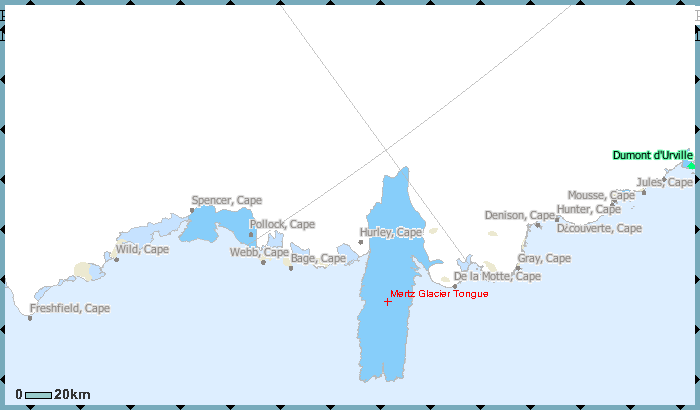
English: map of Mertz Glacier Tongue, George V Coast, East Antarctica |
| Date | 2000s |
| Source | http://gisdata.usgs.gov/website/antarctic_research_atlas/viewer.htm |
| Author | USGS |
Licensing[edit]
This image is in the public domain in the United States because it only contains materials that originally came from the United States Geological Survey, an agency of the United States Department of the Interior. For more information, see the official USGS copyright policy.
|
File history
Click on a date/time to view the file as it appeared at that time.
| Date/Time | Thumbnail | Dimensions | User | Comment | |
|---|---|---|---|---|---|
| current | 13:20, 27 February 2010 | | 700 × 410 (22 KB) | Ratzer (talk | contribs) | {{Information |Description={{en|1=map of Mertz Glacier Tongue, George V Coast, East Antarctica}} |Source=http://gisdata.usgs.gov/website/antarctic_research_atlas/viewer.htm |Author=USGS |Date=2000s |Permission= |other_versions= }} [[Category:Maps of Anta |
You cannot overwrite this file.
File usage on Commons
There are no pages that use this file.
File usage on other wikis
The following other wikis use this file:
- Usage on ar.wikipedia.org
- Usage on en.wikipedia.org
- Usage on es.wikipedia.org
- Usage on fr.wikipedia.org
- Usage on he.wikipedia.org
- Usage on it.wikipedia.org
- Usage on ka.wikipedia.org
- Usage on nn.wikipedia.org
- Usage on sv.wikipedia.org
- Usage on www.wikidata.org
- Usage on zh.wikipedia.org