File:Koppen-Geiger Map COD present-ar.svg
Jump to navigation
Jump to search

Size of this PNG preview of this SVG file: 800 × 500 pixels. Other resolutions: 320 × 200 pixels | 640 × 400 pixels | 1,024 × 640 pixels | 1,280 × 800 pixels | 2,560 × 1,600 pixels | 1,360 × 850 pixels.
Original file (SVG file, nominally 1,360 × 850 pixels, file size: 1.03 MB)
Captions
Captions
Add a one-line explanation of what this file represents
Summary[edit]
| Description |
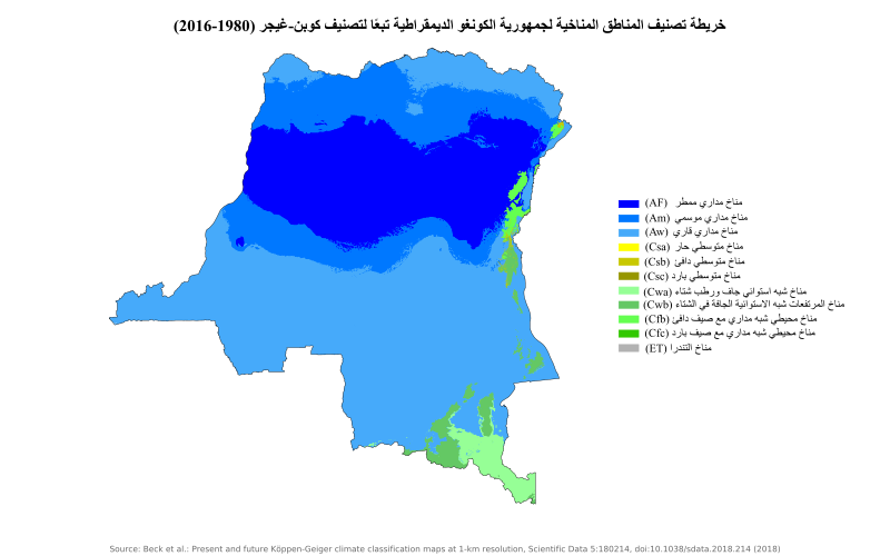
العربية: تصنيف كوبن للمناخ، خريطة تصنيف مناخ جمهورية الكونغو الديمقراطية |
| Date | |
| Source | "Present and future Köppen-Geiger climate classification maps at 1-km resolution". Nature Scientific Data. DOI:10.1038/sdata.2018.214. |
| Author |
|
| Other versions | English |
| This is a retouched picture, which means that it has been digitally altered from its original version. Modifications: Translated to Arabic - عُرِبَت. The original can be viewed here: Koppen-Geiger Map COD present.svg:
|
Licensing[edit]
I, the copyright holder of this work, hereby publish it under the following license:
This file is licensed under the Creative Commons Attribution-Share Alike 4.0 International license.
- You are free:
- to share – to copy, distribute and transmit the work
- to remix – to adapt the work
- Under the following conditions:
- attribution – You must give appropriate credit, provide a link to the license, and indicate if changes were made. You may do so in any reasonable manner, but not in any way that suggests the licensor endorses you or your use.
- share alike – If you remix, transform, or build upon the material, you must distribute your contributions under the same or compatible license as the original.
| This file was contributed as part of a Wikimedians of the Levant activities. Wikimedia Levant is the Wikimedia user group to promoting Wikimedia projects and activities related to free content and open access to knowledge in Levant Region (Jordan, Lebanon, Palestine and Syria).
We work diligently with our members to ensure that media contributed to Wikimedia Commons are of acceptable copyright status. Please refer any inquiries regarding copyright status to wm-levant | ||
|
| ||
| Camera location | | View this and other nearby images on: OpenStreetMap |
|---|
File history
Click on a date/time to view the file as it appeared at that time.
| Date/Time | Thumbnail | Dimensions | User | Comment | |
|---|---|---|---|---|---|
| current | 16:58, 22 June 2021 | | 1,360 × 850 (1.03 MB) | Sandra Hanbo (talk | contribs) | Uploaded own work with UploadWizard |
You cannot overwrite this file.
File usage on Commons
There are no pages that use this file.
File usage on other wikis
The following other wikis use this file: