File:Indian subcontinent drift-fr.svg
Jump to navigation
Jump to search

Size of this PNG preview of this SVG file: 234 × 424 pixels. Other resolutions: 132 × 240 pixels | 265 × 480 pixels | 424 × 768 pixels | 565 × 1,024 pixels | 1,130 × 2,048 pixels.
Original file (SVG file, nominally 234 × 424 pixels, file size: 37 KB)
Captions
Captions
Add a one-line explanation of what this file represents
Summary[edit]
| Description |
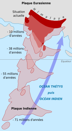
Deutsch: Vor ihrer Kollision mit Asien (Eurasische Platte) legte die indischen Platte eine mehr als 6.000 Km lange Reise zurück. Früher lag die indische Platte weit südlich des Äquators, nahe dem australischen Kontinent. English: The 6,000-km-plus journey of the India landmass (Indian Plate) before its collision with Asia (Eurasian Plate). India was once situated well south of the Equator, near the continent of Australia. Français : Carte montrant la dérive de la plaque du continent indien sur plus de six mille kilomètres, jusqu'à sa collision avec la plaque eurasienne. L'Inde était au départ située dans l'hémisphère sud, près de l'Australie et de l'Antarctique. |
||||
| Date | (UTC) | ||||
| Source | |||||
| Author |
|
||||
| Other versions |
[]
| ||||
| Attribution (required by the license) | © Sémhur / Wikimedia Commons / | ||||
| SVG | W3C-validity not checked.
|
||||
| Graphic Lab |


| Camera location | | View this and other nearby images on: OpenStreetMap |
|---|
Licensing[edit]
This image is in the public domain in the United States because it only contains materials that originally came from the United States Geological Survey, an agency of the United States Department of the Interior. For more information, see the official USGS copyright policy.
|
Original upload log[edit]
This image is a derivative work of the following images:
- File:Indischer_Subkontinent_Drift.png licensed with PD-USGov-USGS
- 2007-03-03T20:05:36Z TomCatX 234x424 (35242 Bytes) Correction #2
- 2007-03-03T19:32:22Z TomCatX 234x424 (39530 Bytes) Correction
- 2007-03-03T19:09:26Z TomCatX 234x424 (298656 Bytes) {{Information |Description= {{Deutsch}} Vor ihrer Kollision mit Asien (Eurasische Platte) legte die indischen Platte eine mehr als 6.000 Km lange Reise zurück. Früher lag die indische Platte weit südlich des Äquators, nah
Uploaded with derivativeFX
File history
Click on a date/time to view the file as it appeared at that time.
| Date/Time | Thumbnail | Dimensions | User | Comment | |
|---|---|---|---|---|---|
| current | 16:09, 14 May 2009 | | 234 × 424 (37 KB) | Sémhur (talk | contribs) | Without the bitmap |
| 16:07, 14 May 2009 |  | 234 × 424 (37 KB) | Sémhur (talk | contribs) | =={{int:summary}}== {{Information |Description={{de|Vor ihrer Kollision mit Asien (Eurasische Platte) legte die indischen Platte eine mehr als 6.000 Km lange Reise zurück. Früher lag die indische Platte weit südlich des Äquators, nahe dem australische |
You cannot overwrite this file.
File usage on Commons
The following 6 pages use this file:
File usage on other wikis
The following other wikis use this file:
- Usage on an.wikipedia.org
- Usage on fr.wikipedia.org
- Usage on rm.wikipedia.org