File:World 1914 empires colonies territory.PNG
Jump to navigation
Jump to search

Size of this preview: 800 × 330 pixels. Other resolutions: 320 × 132 pixels | 640 × 264 pixels | 1,522 × 628 pixels.
Original file (1,522 × 628 pixels, file size: 45 KB, MIME type: image/png)
Captions
Captions
Add a one-line explanation of what this file represents

|
This map image could be re-created using vector graphics as an SVG file. This has several advantages; see Commons:Media for cleanup for more information. If an SVG form of this image is available, please upload it and afterwards replace this template with
{{vector version available|new image name}}.
It is recommended to name the SVG file “World 1914 empires colonies territory.svg”—then the template Vector version available (or Vva) does not need the new image name parameter. |
Summary[edit]
| Description |
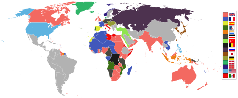
English: World empires and colonies in 1914, just before the First World War.
|
||||||||||||||||
| Date | |||||||||||||||||
| Source | Own work | ||||||||||||||||
| Author | Andrew0921 | ||||||||||||||||
.jpg)
._LOC_2001620596.jpg)
British Empire
France
Spain
Portugal
Netherlands
German Empire
Ottoman
Belgium
Russia
Japan
Denmark
Norway
United States of America
Italy
Independent/other countries
Licensing[edit]
I, the copyright holder of this work, hereby publish it under the following license:
This file is licensed under the Creative Commons Attribution 3.0 Unported license.
- You are free:
- to share – to copy, distribute and transmit the work
- to remix – to adapt the work
- Under the following conditions:
- attribution – You must give appropriate credit, provide a link to the license, and indicate if changes were made. You may do so in any reasonable manner, but not in any way that suggests the licensor endorses you or your use.
File history
Click on a date/time to view the file as it appeared at that time.
| Date/Time | Thumbnail | Dimensions | User | Comment | |
|---|---|---|---|---|---|
| current | 09:28, 8 November 2021 | | 1,522 × 628 (45 KB) | Randomastwritter (talk | contribs) | jubaland |
| 00:00, 14 April 2021 |  | 1,522 × 628 (45 KB) | Offa29 (talk | contribs) | Fixed Togoland colour | |
| 18:57, 24 April 2020 |  | 1,522 × 628 (45 KB) | The- (talk | contribs) | Norwegian flag | |
| 17:08, 24 April 2020 |  | 1,522 × 628 (45 KB) | The- (talk | contribs) | If an old map with wrongly drawn borders is replaced with a better map wth a minor colour error, then fix that minor colour error. Don't just blithely revert to the bad old map. | |
| 21:52, 17 March 2020 |  | 1,474 × 620 (36 KB) | Makkkkus (talk | contribs) | Replaced the Swedish-Norwegian union flag with the Norwegian flag. | |
| 19:25, 13 March 2020 |  | 1,474 × 620 (22 KB) | Morris-frank (talk | contribs) | The new version introduced a big regression (coloring spain in the color of italy), also it did not contribute anything useful. | |
| 21:49, 14 August 2019 |  | 1,522 × 628 (45 KB) | The- (talk | contribs) | More accurate map | |
| 12:47, 5 July 2016 |  | 1,474 × 620 (22 KB) | Maproom (talk | contribs) | Removed borders between provinces of Australia, as requested at https://en.wikipedia.org/wiki/Wikipedia:Graphics_Lab/Map_workshop#FIFA_World_Cup_Maps_-_Colonial_Boundaries , because it had been united into a single dominion before 1914. | |
| 00:00, 26 December 2010 |  | 1,474 × 620 (33 KB) | Quigley (talk | contribs) | by 1914, Qing Dynasty had collapsed and Republic of China established | |
| 13:56, 22 November 2010 |  | 1,474 × 620 (20 KB) | AnonMoos (talk | contribs) | cropping margins, increasing PNG compression |
You cannot overwrite this file.
File usage on Commons
The following 5 pages use this file:
File usage on other wikis
The following other wikis use this file:
- Usage on af.wikipedia.org
- Usage on ar.wikipedia.org
- Usage on azb.wikipedia.org
- Usage on bn.wikipedia.org
- Usage on ca.wikipedia.org
- Usage on da.wikipedia.org
- Usage on en.wikipedia.org
- Usage on eo.wikipedia.org
- Usage on eo.wikiquote.org
- Usage on es.wikipedia.org
- Usage on fa.wikipedia.org
- Usage on fi.wikipedia.org
- Usage on fr.wikipedia.org
- Usage on fy.wikipedia.org
- Usage on gl.wikipedia.org
- Usage on hu.wikipedia.org
- Usage on it.wikipedia.org
- Usage on ja.wikipedia.org
- Usage on jv.wikipedia.org
- Usage on ka.wikipedia.org
- Usage on lv.wikipedia.org
- Usage on mk.wikipedia.org
- Usage on ml.wikipedia.org
- Usage on oc.wikipedia.org
- Usage on pt.wikipedia.org
- Usage on ta.wikipedia.org
- Usage on te.wikipedia.org
View more global usage of this file.