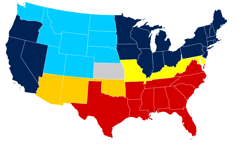
File:US Secession map 1865.svg
From Wikimedia Commons, the free media repository
Jump to navigation
Jump to search

Size of this PNG preview of this SVG file: 800 × 495 pixels. Other resolutions: 320 × 198 pixels | 640 × 396 pixels | 1,024 × 633 pixels | 1,280 × 791 pixels | 2,560 × 1,583 pixels | 959 × 593 pixels.
Original file (SVG file, nominally 959 × 593 pixels, file size: 80 KB)
File information
Structured data
Captions
Captions
Add a one-line explanation of what this file represents
Summary[edit]
| DescriptionUS Secession map 1865.svg |
United States map of 1865, show affiliation of states and territories regarding the Secession War (Civil War.) Legend: |
||||
| Date | |||||
| Source |
A trace of American Civil War map.png, itself a derived work from the US Atlas.
|
||||
| Author | Júlio Reis |
Licensing[edit]
This file is licensed under the Creative Commons Attribution-Share Alike 3.0 Unported license.
- You are free:
- to share – to copy, distribute and transmit the work
- to remix – to adapt the work
- Under the following conditions:
- attribution – You must give appropriate credit, provide a link to the license, and indicate if changes were made. You may do so in any reasonable manner, but not in any way that suggests the licensor endorses you or your use.
- share alike – If you remix, transform, or build upon the material, you must distribute your contributions under the same or compatible license as the original.
|Author=Tintazul
derivative works[edit]
Derivative works of this file: Missouri Compromise Line.svg
File history
Click on a date/time to view the file as it appeared at that time.
| Date/Time | Thumbnail | Dimensions | User | Comment | |
|---|---|---|---|---|---|
| current | 19:07, 16 February 2011 |  | 959 × 593 (80 KB) | Holly Cheng (talk | contribs) | last version won't thumbnail; recreated from File:Blank US Map.svg |
| 09:50, 6 March 2008 |  | 927 × 588 (233 KB) | Escondites (talk | contribs) | {{Information |Description= |Source= |Date= |Author= |Permission= |other_versions= }} | |
| 19:14, 26 June 2007 |  | 882 × 553 (102 KB) | Nostrifikator (talk | contribs) | {{Tintazul |Description=United States map of 1865, show affiliation of states and territories regarding the Secession War (Civil War.) Legend: {{legend|#204A87|Union states}} {{legend|#729FCF|Union territories}} {{legend|#EDD400|Border Union states, permi | |
| 17:10, 23 February 2007 |  | 882 × 553 (102 KB) | Tintazul (talk | contribs) | {{Tintazul |Description=United States map of 1865, show affiliation of states and territories regarding the Secession War (Civil War.) Legend: {{legend|#204A87|Union states}} {{legend|#729FCF|Union territories}} {{legend|#EDD400|Border Union states, permi |
You cannot overwrite this file.
File usage on Commons
The following 7 pages use this file:
File usage on other wikis
The following other wikis use this file:
- Usage on af.wikipedia.org
- Usage on ar.wikipedia.org
- Usage on da.wikipedia.org
- Usage on el.wikipedia.org
- Usage on en.wikipedia.org
- Talk:Abraham Lincoln
- Talk:David Rice Atchison
- Talk:Frigate
- Talk:Jefferson Davis
- Talk:Mark Twain
- Talk:Submarine
- Talk:United States Navy
- Talk:United States Marine Corps
- Talk:William Tecumseh Sherman
- Talk:Harpers Ferry, West Virginia
- Talk:Reconstruction era
- Talk:The Birth of a Nation
- Talk:USS Monitor
- Talk:Emancipation Proclamation
- Talk:Kit Carson
- Talk:HMS Scorpion (1863)
- Talk:Confederate States of America
- Talk:Arlington National Cemetery
- Talk:Second Battle of Bull Run
- Talk:Williamsburg, Virginia
- Talk:Slavery and States' Rights
- Talk:George Pickett
- Talk:Abner Doubleday
- Talk:Battle of the Crater
- Talk:Battle of Antietam
- Talk:Sidney Lanier
- Talk:Henry Morton Stanley
- Talk:Winfield Scott Hancock
- Talk:Buffalo Bill
- Talk:Albert Sidney Johnston
- Talk:Harriet Tubman
- Talk:Lucius Quintus Cincinnatus Lamar
- Talk:George Dewey
- Talk:P. B. S. Pinchback
- Talk:Battle of New Market
- Talk:Fort Donelson
- Talk:Taps (bugle call)
- Talk:Joseph Wheeler
- Talk:George Armstrong Custer
- Talk:First Battle of Bull Run
- Talk:Oliver Otis Howard
- Talk:John Stith Pemberton
- Talk:USS United States (1797)
- Talk:Alferd Packer
View more global usage of this file.
