File:Terrestrial ecoregions USA CAN MEX.svg
Jump to navigation
Jump to search

Size of this PNG preview of this SVG file: 515 × 599 pixels. Other resolutions: 206 × 240 pixels | 412 × 480 pixels | 660 × 768 pixels | 880 × 1,024 pixels | 1,760 × 2,048 pixels | 1,712 × 1,992 pixels.
Original file (SVG file, nominally 1,712 × 1,992 pixels, file size: 1.19 MB)
Captions
Captions
Add a one-line explanation of what this file represents
Summary[edit]
| Description |
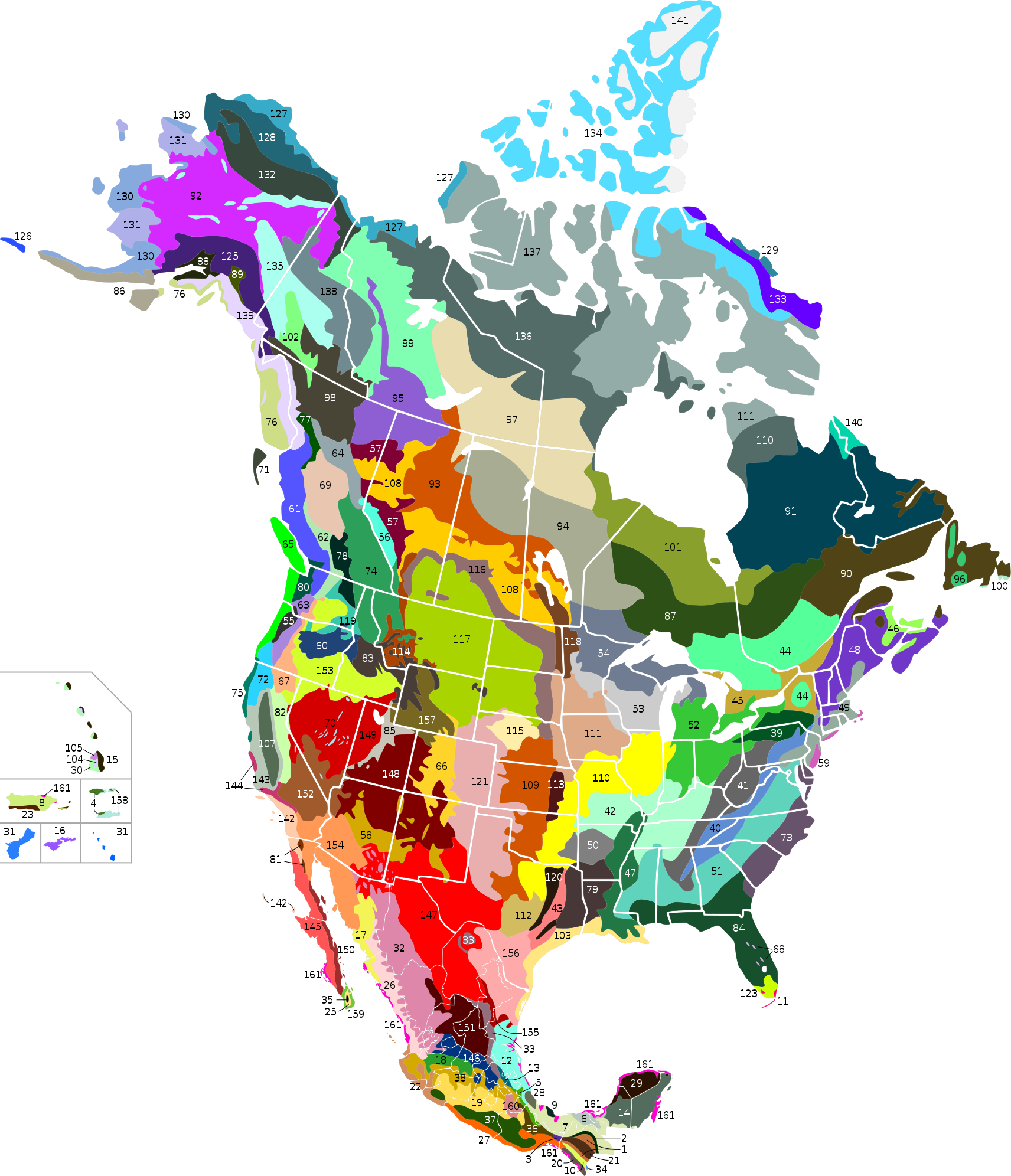
English: Ecoregions map of Canada, United-States and Mexico - level III.
24. Islas Revillagigedo Dry Forests (not shown)
88. Cook Inlet Taiga
106. Northwestern Hawaiian Scrub (not shown)
119. Palouse Grasslands
122. Central Mexican Wetlands (not shown, too small)
123. Everglades
124. Zacatonal (not shown, too small)
134. High Arctic Tundra
136. Low Arctic Tundra
137. Middle Arctic Tundra
141. Permanent Ice
147. Chihuahuan Desert
152. Mojave Desert
154. Sonoran Desert
155. Tamaulipan Matorral
156. Tamaulipan Mezquital
161. Mangroves
Note: The ecoregions of southern Florida and the southern portion of Mexico belong to the Neotropical realm rather than the Nearctic realm. Español: Mapa de las ecorregiones de Canadá, los Estados Unidos y México - nivel III. Français : Carte des écorégions du Canada, des États-Unis et du Mexique - niveau III. |
| Date | |
| Source |
This W3C-unspecified vector image was created with Inkscape . |
| Author | Cephas |
| Other versions |
  |
Licensing[edit]
I, the copyright holder of this work, hereby publish it under the following licenses:

|
Permission is granted to copy, distribute and/or modify this document under the terms of the GNU Free Documentation License, Version 1.2 or any later version published by the Free Software Foundation; with no Invariant Sections, no Front-Cover Texts, and no Back-Cover Texts. A copy of the license is included in the section entitled GNU Free Documentation License. |
This file is licensed under the Creative Commons Attribution-Share Alike 3.0 Unported, 2.5 Generic, 2.0 Generic and 1.0 Generic license.
- You are free:
- to share – to copy, distribute and transmit the work
- to remix – to adapt the work
- Under the following conditions:
- attribution – You must give appropriate credit, provide a link to the license, and indicate if changes were made. You may do so in any reasonable manner, but not in any way that suggests the licensor endorses you or your use.
- share alike – If you remix, transform, or build upon the material, you must distribute your contributions under the same or compatible license as the original.
You may select the license of your choice.
File history
Click on a date/time to view the file as it appeared at that time.
| Date/Time | Thumbnail | Dimensions | User | Comment | |
|---|---|---|---|---|---|
| current | 22:53, 1 December 2020 | | 1,712 × 1,992 (1.19 MB) | Ponderosapine210 (talk | contribs) | Improved visibility of the sky islands in New Mexico. |
| 22:50, 1 December 2020 |  | 1,712 × 1,992 (1.19 MB) | Ponderosapine210 (talk | contribs) | Further refinement of the Madrean Sky Islands and Sinaloa-Sonora transitional forests. | |
| 22:34, 24 November 2020 |  | 1,712 × 1,992 (1.19 MB) | Ponderosapine210 (talk | contribs) | I wasn't fully satisfied with my previous work so I adjusted the ecoregions of Sonora for a final time. | |
| 00:23, 24 November 2020 |  | 1,712 × 1,992 (1.19 MB) | Ponderosapine210 (talk | contribs) | Adjusted ecoregions in northern Sonora. | |
| 02:12, 23 November 2020 |  | 1,712 × 1,992 (1.19 MB) | Ponderosapine210 (talk | contribs) | Added the prominent islands of Manitoulin (Ontario) and Isle Royale (Michigan) to the Great Lakes. Made minor adjustments to reduce white lines between ecoregions. | |
| 02:35, 22 November 2020 |  | 1,712 × 1,992 (1.19 MB) | Ponderosapine210 (talk | contribs) | Correction on no. 142 | |
| 00:37, 22 November 2020 |  | 1,712 × 1,992 (1.19 MB) | Ponderosapine210 (talk | contribs) | Added the remaining four U.S. territories and added two missing ecoregions on the mainland, per WWF definitions. Renumbered each ecoregion based upon their biogeographic realms (Nearctic first, then Neotropical and Oceanian) and biomes. Changed colours of a couple ecoregions. | |
| 08:38, 20 November 2020 |  | 1,712 × 1,992 (1.17 MB) | Ponderosapine210 (talk | contribs) | Minor formatting adjustments. | |
| 01:47, 20 November 2020 |  | 1,712 × 1,992 (1.17 MB) | Ponderosapine210 (talk | contribs) | Updated with the redrawn Great Basin montane ecoregion and other minor visual improvements. | |
| 22:13, 19 November 2020 |  | 1,712 × 1,992 (1.17 MB) | Ponderosapine210 (talk | contribs) | Added the U.S. territory of Puerto Rico, which is large enough to warrant inclusion. Coloured in some blank areas and islands according to their appropriate WWF ecoregion. Minor aesthetic adjustments to eliminate some of the thin white lines between ecoregions and to accommodate Puerto Rico. |
You cannot overwrite this file.
File usage on Commons
The following 2 pages use this file:
File usage on other wikis
The following other wikis use this file:
- Usage on af.wikipedia.org
- Usage on de.wikipedia.org
- Usage on en.wikipedia.org
- Usage on eo.wikipedia.org
- Usage on fr.wikipedia.org
- Usage on ro.wikipedia.org
- Comitat al unui stat al Statelor Unite ale Americii
- Listă de comitate din statul Arkansas
- Listă de comitate din statul Florida
- Listă de comitate din statul Illinois
- Listă de comitate din statul Iowa
- Listă de comitate din statul Kentucky
- Listă de comitate din statul Mississippi
- Listă de comitate din statul Missouri
- Listă de orașe din statul Alabama
- Listă de localități din statul Indiana, SUA
- Listă de orașe din statul Alaska
- Listă de orașe din statul Arkansas
- Listă de orașe din California
- Listă de orașe din statul Connecticut
- Listă de orașe din statul Florida
- Listă de orașe din statul Idaho
- Listă de orașe din statul Illinois
- Listă de orașe din statul Iowa
- Listă de orașe din statul Kansas
- Listă de orașe din statul Kentucky
- Listă de localități din statul Michigan
- Listă de orașe din statul Mississippi
- Listă de orașe din statul Missouri
- Listă de localități din statul New Hampshire
- Listă de orașe din statul Carolina de Nord
- Listă de orașe din statul Dakota de Nord
- Listă de orașe din Ohio
- Listă de orașe din statul Oklahoma
- Listă de localități din statul Oregon
- Listă de orașe din statul Pennsylvania
- Listă de orașe din statul Carolina de Sud
- Listă de orașe din Dakota de Sud
- Listă de orașe din statul Texas
- Listă de orașe din statul Utah
- Listă de orașe din statul Virginia de Vest
- Listă de comitate din statul Oklahoma
View more global usage of this file.
Metadata
Categories:
- Nearctic SVG maps of WWF ecoregions
- Neotropical ecoregion maps
- SVG maps of North America
- Nature of North America
- SVG maps of Canada
- Maps of Mexico in North America
- Maps of regions of the United States
- Nature of Mexico
- Nature of the United States
- Flora of the United States
- Flora of Mexico
- Ecoregions of Mexico (WWF)
- Ecoregions of Canada (WWF)
- Ecoregions of the United States (WWF)
- Terrestrial Ecoregions of Central America & Caribbean (One Earth)
- Terrestrial Ecoregions of Northern America (One Earth)