File:Soviet Union - Russian SFSR (1922).svg
Jump to navigation
Jump to search

Size of this PNG preview of this SVG file: 592 × 376 pixels. Other resolutions: 320 × 203 pixels | 640 × 406 pixels | 1,024 × 650 pixels | 1,280 × 813 pixels | 2,560 × 1,626 pixels.
Original file (SVG file, nominally 592 × 376 pixels, file size: 243 KB)
Captions
Captions
Add a one-line explanation of what this file represents
Summary[edit]
.svg&action=edit§ion=1)
| Description |
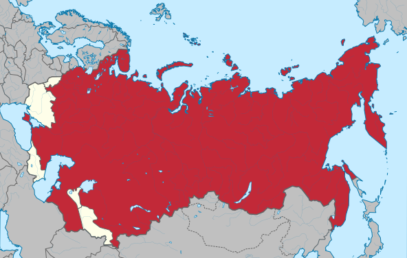
English: The Russian SFSR before 1936 territorial changes. (Based on locator map of the Transcaucasian SFSR in the Soviet Union (1922-1936). Extracted from File:Soviet Union location map (1937).svg)
Русский: РСФСР с момента образования СССР и до территориальных изменений 1936 года. |
| Date | (UTC) |
| Source |
This file was derived from: Soviet Union - Transcaucasia.svg: |
| Author |
|
.svg)
| This is a retouched picture, which means that it has been digitally altered from its original version. Modifications: the RSFSR map. The original can be viewed here: Soviet Union - Transcaucasia.svg:
|
Licensing[edit]
.svg&action=edit§ion=2)
This file is licensed under the Creative Commons Attribution-Share Alike 3.0 Unported license.
- You are free:
- to share – to copy, distribute and transmit the work
- to remix – to adapt the work
- Under the following conditions:
- attribution – You must give appropriate credit, provide a link to the license, and indicate if changes were made. You may do so in any reasonable manner, but not in any way that suggests the licensor endorses you or your use.
- share alike – If you remix, transform, or build upon the material, you must distribute your contributions under the same or compatible license as the original.
Original upload log[edit]
.svg&action=edit§ion=3)
This image is a derivative work of the following images:
- File:Soviet_Union_-_Transcaucasia.svg licensed with Cc-by-sa-3.0
- 2013-11-22T05:03:08Z Shadowxfox 592x376 (234100 Bytes) background
- 2013-11-22T04:52:53Z Shadowxfox 592x377 (237003 Bytes) User created page with UploadWizard
Uploaded with derivativeFX
File history
Click on a date/time to view the file as it appeared at that time.
.svg&dir=prev)
.svg&offset=20141226201117)
.svg&offset=&limit=20)
.svg&offset=&limit=50)
.svg&offset=&limit=100)
.svg&offset=&limit=250)
.svg&offset=&limit=500)
| Date/Time | Thumbnail | Dimensions | User | Comment | |
|---|---|---|---|---|---|
| current | 18:33, 3 November 2021 | | 592 × 376 (243 KB) | Milenioscuro (talk | contribs) | color |
| 14:19, 5 September 2020 |  | 592 × 376 (243 KB) | Claude Zygiel (talk | contribs) | Map of the controlled territory of USSR (claims were some others: an area in north of Leningrad, east bank of river Narva, Izborsk. | |
| 18:38, 12 September 2018 |  | 592 × 376 (247 KB) | Milenioscuro (talk | contribs) | standard red | |
| 13:45, 9 September 2018 |  | 592 × 376 (242 KB) | Anonimu (talk | contribs) | Bessarabian claim | |
| 15:45, 12 January 2015 |  | 592 × 376 (243 KB) | Knyaz-1988 (talk | contribs) | Новая версия | |
| 16:15, 11 January 2015 |  | 592 × 376 (243 KB) | Knyaz-1988 (talk | contribs) | Новая версия | |
| 16:15, 11 January 2015 |  | 592 × 376 (235 KB) | Knyaz-1988 (talk | contribs) | Reverted to version as of 11:54, 11 January 2015 | |
| 15:28, 11 January 2015 |  | 592 × 376 (242 KB) | Knyaz-1988 (talk | contribs) | Новая версия | |
| 11:54, 11 January 2015 |  | 592 × 376 (235 KB) | Knyaz-1988 (talk | contribs) | Новая версия | |
| 20:11, 26 December 2014 |  | 592 × 376 (233 KB) | Milenioscuro (talk | contribs) | Reverted to version as of 16:05, 21 March 2014 |
You cannot overwrite this file.
File usage on Commons
The following 4 pages use this file:
.svg)
.svg)
File usage on other wikis
The following other wikis use this file:
- Usage on af.wikipedia.org
- Usage on als.wikipedia.org
- Usage on ar.wikipedia.org
- Usage on arz.wikipedia.org
- Usage on ba.wikipedia.org
- Usage on be-tarask.wikipedia.org
- Usage on bg.wikipedia.org
- Usage on bs.wikipedia.org
- Usage on de.wikipedia.org
- Usage on el.wikipedia.org
- Usage on en.wikipedia.org
- Usage on es.wikipedia.org
- Usage on fi.wikipedia.org
- Usage on fr.wikipedia.org
- Usage on hu.wikipedia.org
- Usage on hy.wikipedia.org
- Usage on hyw.wikipedia.org
- Usage on id.wikipedia.org
- Usage on it.wikipedia.org
- Usage on ja.wikipedia.org
- Usage on km.wikipedia.org
- Usage on krc.wikipedia.org
- Usage on lt.wikipedia.org
- Usage on lv.wikipedia.org
- Usage on pl.wikipedia.org
- Usage on pt.wikipedia.org
- Usage on ro.wikipedia.org
- Usage on ru.wikipedia.org
- Usage on sr.wikipedia.org
- Usage on te.wikipedia.org
- Usage on tr.wikipedia.org
- Usage on uk.wikipedia.org
- Usage on vi.wikipedia.org
- Usage on www.wikidata.org
- Usage on zh.wikipedia.org
.svg&oldid=820145403)