File:SouthAfricaOMC.png
Jump to navigation
Jump to search

Size of this preview: 542 × 599 pixels. Other resolutions: 217 × 240 pixels | 434 × 480 pixels | 695 × 768 pixels | 926 × 1,024 pixels | 1,367 × 1,511 pixels.
Original file (1,367 × 1,511 pixels, file size: 128 KB, MIME type: image/png)
Captions
Captions
Add a one-line explanation of what this file represents
Summary[edit]
| Description |
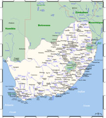
English: A map showing South Africa's cities, main towns, selected villages, rivers, and its highest peak. This map's source is here, with the uploader's modifications, and the GMT homepage says that the tools are released under the GNU General Public License. |
| Date | 20 December 2007 (original upload date) |
| Source | Transferred from en.wikipedia to Commons by Mario1952 using CommonsHelper. |
| Author |
Kelisi at English Wikipedia. Later version(s) were uploaded by JMK at en.wikipedia. This map's source is here, with the uploader's modifications, and the GMT homepage says that the tools are released under the GNU General Public License. |
Licensing[edit]
Kelisi at the English-language Wikipedia, the copyright holder of this work, hereby publishes it under the following license:
| This file is licensed under the Creative Commons Attribution-Share Alike 3.0 Unported license. Subject to disclaimers. | ||
| Attribution: Kelisi at the English-language Wikipedia | ||
| ||
| This licensing tag was added to this file as part of the GFDL licensing update. |

|
Permission is granted to copy, distribute and/or modify this document under the terms of the GNU Free Documentation License, Version 1.2 or any later version published by the Free Software Foundation; with no Invariant Sections, no Front-Cover Texts, and no Back-Cover Texts. A copy of the license is included in the section entitled GNU Free Documentation License. Subject to disclaimers. |
Original upload log[edit]
The original description page was here. All following user names refer to en.wikipedia.
- 2007-12-20 10:55 JMK 1367×1511× (109398 bytes) Update under GFDL licence.
- 2007-12-20 10:19 JMK 1367×1511× (109349 bytes) Update under GFDL licence.
- 2007-12-20 09:25 JMK 1367×1511× (109369 bytes) Update under GFDL licence. ~~~~
- 2007-08-21 00:13 Kelisi 1366×1511× (93673 bytes) Updating towns' names.
- 2007-08-19 16:19 Kelisi 1366×1511× (93854 bytes) == Summary == A map showing South Africa's cities, main towns, selected villages, rivers and its highest peak. This map's source is [http://www.aquarius.ifm-geomar.de/ here], with the uploader's modifications, and the [http://gmt.soest.hawaii.edu/ GMT hom
File history
Click on a date/time to view the file as it appeared at that time.
| Date/Time | Thumbnail | Dimensions | User | Comment | |
|---|---|---|---|---|---|
| current | 05:55, 23 August 2023 | | 1,367 × 1,511 (128 KB) | Kelisi (talk | contribs) | tweaking |
| 05:47, 4 April 2023 |  | 1,367 × 1,511 (128 KB) | Kelisi (talk | contribs) | Two more placename changes | |
| 05:44, 29 June 2022 |  | 1,367 × 1,511 (128 KB) | Kelisi (talk | contribs) | Several more names plotted | |
| 17:34, 1 April 2022 |  | 1,367 × 1,511 (128 KB) | Kelisi (talk | contribs) | Sizeable town unaccountably overlooked. | |
| 06:00, 5 February 2022 |  | 1,367 × 1,511 (128 KB) | Kelisi (talk | contribs) | Several more names plotted | |
| 03:36, 3 February 2022 |  | 1,367 × 1,511 (128 KB) | Kelisi (talk | contribs) | Several more names plotted | |
| 07:46, 7 January 2022 |  | 1,367 × 1,511 (128 KB) | Kelisi (talk | contribs) | A few placename changes and one misspelling corrected | |
| 18:37, 29 June 2020 |  | 1,367 × 1,511 (128 KB) | Kelisi (talk | contribs) | Name changes: Cala→Kala Mafikeng→Mahikeng Nelspruit→Mbombela Piet Retief→eMkhondo | |
| 04:53, 29 June 2020 |  | 1,367 × 1,511 (128 KB) | Kelisi (talk | contribs) | Grahamstown→Makhanda | |
| 20:05, 20 August 2019 |  | 1,367 × 1,511 (126 KB) | Kelisi (talk | contribs) | Swaziland is now called Eswatini. |
You cannot overwrite this file.
File usage on Commons
The following 2 pages use this file:
File usage on other wikis
The following other wikis use this file:
- Usage on en.wikinews.org
- Usage on ja.wikipedia.org
- Usage on pl.wikipedia.org
- Usage on pt.wikipedia.org
- Usage on ru.wikipedia.org
- Usage on simple.wikipedia.org
- Usage on sk.wikipedia.org
- Usage on sw.wikipedia.org
- Usage on uk.wikipedia.org
- Usage on www.wikidata.org
- Usage on xmf.wikipedia.org