File:SaintVincentGrenadinenKarte.png
Jump to navigation
Jump to search
No higher resolution available.
SaintVincentGrenadinenKarte.png (330 × 355 pixels, file size: 17 KB, MIME type: image/png)
Captions
Captions
Add a one-line explanation of what this file represents
| Description |
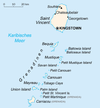
English: Map of the Grenadines from CIA World Factbook. The Grenadines are a Caribbean island chain that belongs to either St. Vincent and the Grenadines or Barbados. |
|||
| Source | Central Intelligence Agency's World Factbook | |||
| Author | United States Central Intelligence Agency | |||
| Permission (Reusing this file) |
|

File history
Click on a date/time to view the file as it appeared at that time.
| Date/Time | Thumbnail | Dimensions | User | Comment | |
|---|---|---|---|---|---|
| current | 19:46, 19 November 2011 | | 330 × 355 (17 KB) | Pilettes (talk | contribs) | border deleted |
| 11:38, 13 June 2006 |  | 330 × 355 (11 KB) | Wolf-Dieter (talk | contribs) | Map of the Grenadines, public domain from CIA World Factbook. adopted from http://de.wikipedia.org/wiki/Bild:SaintVincentGrenadinenKarte.png |
You cannot overwrite this file.
File usage on Commons
The following 4 pages use this file:
File usage on other wikis
The following other wikis use this file:
- Usage on af.wikipedia.org
- Usage on als.wikipedia.org
- Usage on ar.wikipedia.org
- Usage on arz.wikipedia.org
- Usage on ast.wikipedia.org
- Usage on az.wikipedia.org
- Usage on ceb.wikipedia.org
- Usage on ce.wikipedia.org
- Usage on de.wikipedia.org
- Usage on de.wikinews.org
- Usage on de.wikivoyage.org
- Usage on de.wiktionary.org
- Usage on el.wikipedia.org
- Usage on es.wikipedia.org
- Usage on fi.wikipedia.org
- Usage on frr.wikipedia.org
- Usage on gl.wikipedia.org
- Usage on it.wikipedia.org
View more global usage of this file.