File:Revised Afrikaans map Jul 2020.png
Jump to navigation
Jump to search

Size of this preview: 800 × 395 pixels. Other resolutions: 320 × 158 pixels | 640 × 316 pixels | 1,500 × 740 pixels.
Original file (1,500 × 740 pixels, file size: 78 KB, MIME type: image/png)
Captions
Captions
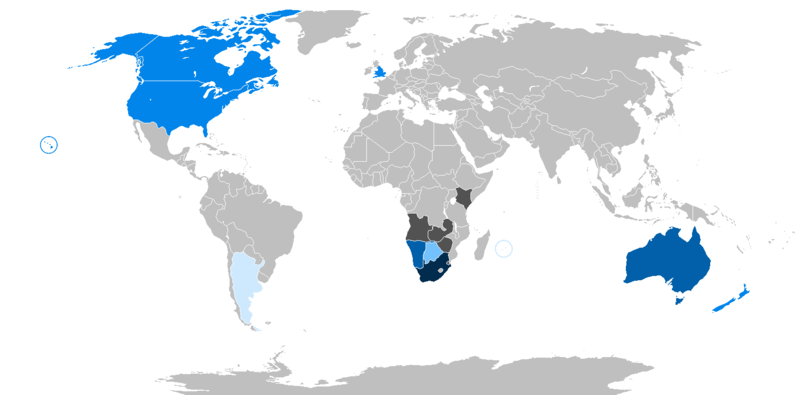
Map of countries with Afrikaans speakers
Summary[edit]
| Description |
Буряад: Revised Afrikaans map Jul 2020  250,000 tot 7,000,000 sprekers 40,000 tot 250,000 sprekers 10,000 tot 40,000 sprekers 1,000 tot 10,000 sprekers Onder 1,000 sprekers Onbekende bevolking |
| Date | |
| Source | Own work |
| Author | Enkhsaihan2005 |
Licensing[edit]
I, the copyright holder of this work, hereby publish it under the following license:
This file is licensed under the Creative Commons Attribution-Share Alike 4.0 International license.
- You are free:
- to share – to copy, distribute and transmit the work
- to remix – to adapt the work
- Under the following conditions:
- attribution – You must give appropriate credit, provide a link to the license, and indicate if changes were made. You may do so in any reasonable manner, but not in any way that suggests the licensor endorses you or your use.
- share alike – If you remix, transform, or build upon the material, you must distribute your contributions under the same or compatible license as the original.
File history
Click on a date/time to view the file as it appeared at that time.
| Date/Time | Thumbnail | Dimensions | User | Comment | |
|---|---|---|---|---|---|
| current | 04:08, 20 July 2021 | | 1,500 × 740 (78 KB) | Enkhsaihan2005 (talk | contribs) | Uploaded own work with UploadWizard |
You cannot overwrite this file.
File usage on Commons
The following page uses this file:
File usage on other wikis
The following other wikis use this file:
- Usage on af.wikipedia.org
- Usage on bxr.wikipedia.org
- Usage on el.wikipedia.org
- Usage on ga.wikipedia.org
- Usage on ha.wikipedia.org