File:Pueblos indigenas de Chile.svg
Jump to navigation
Jump to search

Size of this PNG preview of this SVG file: 800 × 223 pixels. Other resolutions: 320 × 89 pixels | 640 × 178 pixels | 1,024 × 285 pixels | 1,280 × 356 pixels | 2,560 × 713 pixels | 3,000 × 835 pixels.
Original file (SVG file, nominally 3,000 × 835 pixels, file size: 1.29 MB)
Captions
Captions
Add a one-line explanation of what this file represents
Summary[edit]
| Description |
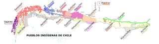
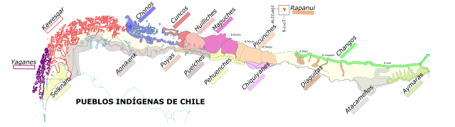
Español: Distribución regional de los pueblos indígenas precolombinos de Chile |
| Date | |
| Source |
This file was derived from: Chile location map (+1998 agreement rectangle).svg según educarchile pueblos indígenas.gif |
| Author | Createaccount |
| Other versions |
.svg)
Licensing[edit]
I, the copyright holder of this work, hereby publish it under the following licenses:

|
Permission is granted to copy, distribute and/or modify this document under the terms of the GNU Free Documentation License, Version 1.2 or any later version published by the Free Software Foundation; with no Invariant Sections, no Front-Cover Texts, and no Back-Cover Texts. A copy of the license is included in the section entitled GNU Free Documentation License. |
This file is licensed under the Creative Commons Attribution-Share Alike 3.0 Unported license.
Attribution: Createaccount
- You are free:
- to share – to copy, distribute and transmit the work
- to remix – to adapt the work
- Under the following conditions:
- attribution – You must give appropriate credit, provide a link to the license, and indicate if changes were made. You may do so in any reasonable manner, but not in any way that suggests the licensor endorses you or your use.
- share alike – If you remix, transform, or build upon the material, you must distribute your contributions under the same or compatible license as the original.
You may select the license of your choice.
File history
Click on a date/time to view the file as it appeared at that time.
| Date/Time | Thumbnail | Dimensions | User | Comment | |
|---|---|---|---|---|---|
| current | 15:28, 22 December 2017 | 3,000 × 835 (1.29 MB) | Janitoalevic (talk | contribs) | Mejores límites territoriales de los pueblos indígenas. | |
| 23:29, 20 December 2017 | 3,000 × 835 (1.28 MB) | Janitoalevic (talk | contribs) | Fixed Rapanui | ||
| 01:08, 5 December 2017 | 3,000 × 835 (1.32 MB) | Janitoalevic (talk | contribs) | Fixed borders. | ||
| 03:56, 9 August 2017 | 3,000 × 835 (1.11 MB) | Tabascofernandez (talk | contribs) | Reverted to version as of 09:19, 24 September 2015 (UTC) | ||
| 03:44, 9 August 2017 | 835 × 3,000 (1.53 MB) | Tabascofernandez (talk | contribs) | north direction up | ||
| 09:19, 24 September 2015 | 3,000 × 835 (1.11 MB) | Milenioscuro (talk | contribs) | Pehunche -> Pehuenche | ||
| 09:28, 4 October 2014 | 3,000 × 835 (1.11 MB) | Keysanger (talk | contribs) | Mejor visión horizontal, no como en los textos de estudio. | ||
| 09:24, 4 October 2014 | 3,000 × 835 (1.11 MB) | Keysanger (talk | contribs) | Mejor visión horizontal, no como en los textos de estudio. | ||
| 17:03, 9 January 2014 | 2,807 × 797 (1.14 MB) | Osepu (talk | contribs) | Mejor visión horizontal, como en los textos de estudio. | ||
| 07:41, 17 October 2013 | 3,000 × 835 (1.11 MB) | Keysanger (old) (talk | contribs) | Pascuenses added |
You cannot overwrite this file.
File usage on Commons
The following 2 pages use this file:
File usage on other wikis
The following other wikis use this file:
- Usage on af.wikipedia.org
- Usage on ast.wikipedia.org
- Usage on azb.wikipedia.org
- Usage on br.wikipedia.org
- Usage on ca.wikipedia.org
- Usage on cs.wikipedia.org
- Usage on de.wikipedia.org
- Usage on en.wikipedia.org
- Usage on eo.wikipedia.org
- Usage on es.wikipedia.org
- Usage on eu.wikipedia.org
- Usage on fr.wikipedia.org
View more global usage of this file.