File:Population densities in Spain (2007).svg
Jump to navigation
Jump to search

Size of this PNG preview of this SVG file: 568 × 387 pixels. Other resolutions: 320 × 218 pixels | 640 × 436 pixels | 1,024 × 698 pixels | 1,280 × 872 pixels | 2,560 × 1,744 pixels.
Original file (SVG file, nominally 568 × 387 pixels, file size: 1.5 MB)
Captions
Captions
Add a one-line explanation of what this file represents
Summary[edit]
.svg&action=edit§ion=1)
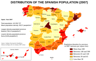
| Description | Map of Spain showing the population densities by province, according to the 1st January 2007 Instituto Nacional de Estadística census. |
| Date | |
| Source | Instituto Nacional de Estadística de España [1]. |
| Author | Created by Rodriguillo, from Image:Provinces of Spain.svg, created by Emilio Gómez Fernández |
| Other versions | Image:Densidades de población en España (2007).svg (in Spanish) |
.svg)
Licensing[edit]
.svg&action=edit§ion=2)
| This work has been released into the public domain by its author, Rodriguillo. This applies worldwide. In some countries this may not be legally possible; if so: |
File history
Click on a date/time to view the file as it appeared at that time.
| Date/Time | Thumbnail | Dimensions | User | Comment | |
|---|---|---|---|---|---|
| current | 16:29, 6 February 2008 | | 568 × 387 (1.5 MB) | Rodriguillo (talk | contribs) | == Summary == {{Information |Description= Map of Spain showing the population densities by province, according to the 1st January 2007 ''Instituto Nacional de Estadística'' census. |Source= Instituto Nacional de Estadística de España [http://www.ine.e |
You cannot overwrite this file.
File usage on Commons
The following page uses this file:
-tr.svg)
File usage on other wikis
The following other wikis use this file:
- Usage on af.wikipedia.org
- Usage on bg.wikipedia.org
- Usage on cs.wikipedia.org
- Usage on en.wikipedia.org
- Usage on zh.wikipedia.org
.svg&oldid=748996890)