File:Polska 1333 - 1370.png
Jump to navigation
Jump to search

Size of this preview: 630 × 599 pixels. Other resolutions: 252 × 240 pixels | 505 × 480 pixels | 808 × 768 pixels | 1,077 × 1,024 pixels | 2,153 × 2,048 pixels | 2,636 × 2,507 pixels.
Original file (2,636 × 2,507 pixels, file size: 1.28 MB, MIME type: image/png)
Captions
Captions
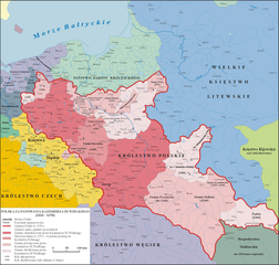
(En) Map of Poland and territorial borders during the reign of Casimir III the Great
| Description |
English: Map of Poland and territorial borders during the reign of Casimir III the Great (1333 - 1370) |
| Date | |
| Source | Own work na podstawie "Ilustrowany atlas historii Polski, wyd. Demart, Warszawa 2006" |
| Author | Poznaniak |
| Permission (Reusing this file) |
I, the copyright holder of this work, hereby publish it under the following license: This file is licensed under the Creative Commons Attribution-Share Alike 3.0 Unported license.
|
| Other versions |
.png) |

|
This historical map image could be re-created using vector graphics as an SVG file. This has several advantages; see Commons:Media for cleanup for more information. If an SVG form of this image is available, please upload it and afterwards replace this template with
{{vector version available|new image name}}.
It is recommended to name the SVG file “Polska 1333 - 1370.svg”—then the template Vector version available (or Vva) does not need the new image name parameter. |
File history
Click on a date/time to view the file as it appeared at that time.
| Date/Time | Thumbnail | Dimensions | User | Comment | |
|---|---|---|---|---|---|
| current | 08:16, 11 December 2020 | | 2,636 × 2,507 (1.28 MB) | ElCet (talk | contribs) | one of the bigger cities in Silesia back then |
| 17:16, 18 June 2020 |  | 2,636 × 2,507 (1.39 MB) | Poznaniak (talk | contribs) | Reverted to version as of 13:59, 7 October 2012 (UTC) nie po polsku, anachronizm | |
| 17:02, 12 June 2020 |  | 2,636 × 2,507 (1.35 MB) | Claude Zygiel (talk | contribs) | Ziemia Pokucie ([http://digi.ub.uni-heidelberg.de/diglit/skw1996/0457?sid=2c1eb70d8bde66653b23d0ee2a80832a] + [http://dir.icm.edu.pl/pl/Slownik_geograficzny/tom VIII/pp.550-555]) | |
| 13:59, 7 October 2012 |  | 2,636 × 2,507 (1.39 MB) | Poznaniak (talk | contribs) | popr. | |
| 20:58, 29 December 2009 |  | 2,636 × 2,507 (1.42 MB) | Poznaniak (talk | contribs) | popr. | |
| 11:15, 4 September 2008 |  | 2,637 × 2,507 (1.44 MB) | Poznaniak (talk | contribs) | {{Information |Description= |Source= |Date= |Author= |Permission= |other_versions= }} | |
| 18:59, 11 August 2008 |  | 2,636 × 2,507 (1.39 MB) | Poznaniak (talk | contribs) | ||
| 14:48, 3 August 2008 |  | 2,636 × 2,507 (1.39 MB) | Poznaniak (talk | contribs) | ||
| 13:05, 9 July 2008 |  | 2,636 × 2,507 (1.47 MB) | Poznaniak (talk | contribs) | {{Information |Description= |Source= |Date= |Author= |Permission= |other_versions= }} | |
| 16:29, 29 June 2008 |  | 2,636 × 2,507 (1.45 MB) | Poznaniak (talk | contribs) | {{Information |Description=Mapa Polski za panowania Kazimierza III Wielkiego (1333 - 1370) |Source=własna praca |Date=29.06.2008 |Author=Poznaniak |Permission={{self2|GFDL|cc-by-sa-2.5,2.0,1.0}} }} [[Category:Maps of the history of P |
You cannot overwrite this file.
File usage on Commons
The following 4 pages use this file:
File usage on other wikis
The following other wikis use this file:
- Usage on af.wikipedia.org
- Usage on ar.wikipedia.org
- Usage on ba.wikipedia.org
- Usage on be.wikipedia.org
- Usage on br.wikipedia.org
- Usage on ca.wikipedia.org
- Usage on cs.wikipedia.org
- Usage on da.wikipedia.org
- Usage on de.wikipedia.org
- Usage on el.wikipedia.org
- Usage on en.wikipedia.org
- Casimir III the Great
- Kingdom of Poland
- Galicia (Eastern Europe)
- Treaty of Kalisz (1343)
- Territorial evolution of Poland
- Lithuania–Poland relations
- Galicia–Volhynia Wars
- Treaty of Trentschin
- History of Poland during the Piast dynasty
- Lithuania–Poland border
- User:Falcaorib
- Polish irredentism
- User talk:2804:214:85D5:66E2:9433:EE28:15B8:C4F3
- User:Artemis Andromeda/sandbox/d4
- Draft:Warsaw Trial 1339
- Usage on eo.wikipedia.org
- Usage on es.wikipedia.org
- Usage on et.wikipedia.org
View more global usage of this file.