File:Plan des anciens arrondissements de Paris avec leurs quartiers.svg
Jump to navigation
Jump to search

Size of this PNG preview of this SVG file: 800 × 562 pixels. Other resolutions: 320 × 225 pixels | 640 × 449 pixels | 1,024 × 719 pixels | 1,280 × 899 pixels | 2,560 × 1,798 pixels | 3,039 × 2,134 pixels.
Original file (SVG file, nominally 3,039 × 2,134 pixels, file size: 174 KB)
Captions
Captions
Add a one-line explanation of what this file represents
Summary[edit]
| Description |
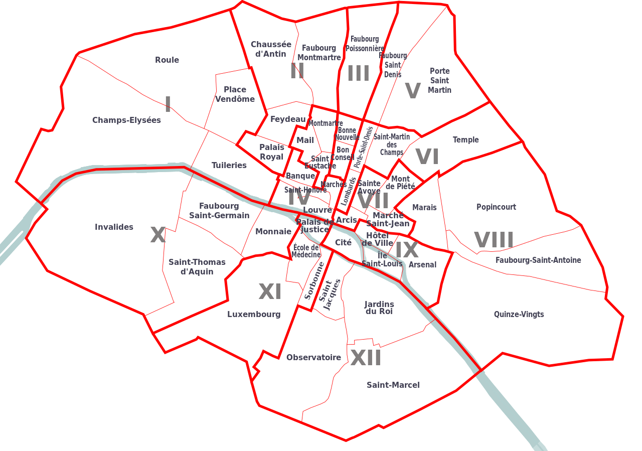
English: Map of former arrondissements of Paris (1795 to 1860)
Français : Plan des anciens arrondissements de Paris, entre 1795 et 1860, avec les quartiers |
| Date | |
| Source | Own work à partir de Dictionnaire historique des rues et monuments de Paris en 1855, de Félix et Louis Lazare |
| Author | Starus |
Licensing[edit]
I, the copyright holder of this work, hereby publish it under the following licenses:

|
Permission is granted to copy, distribute and/or modify this document under the terms of the GNU Free Documentation License, Version 1.2 or any later version published by the Free Software Foundation; with no Invariant Sections, no Front-Cover Texts, and no Back-Cover Texts. A copy of the license is included in the section entitled GNU Free Documentation License. |
This file is licensed under the Creative Commons Attribution-Share Alike 3.0 Unported, 2.5 Generic, 2.0 Generic and 1.0 Generic license.
- You are free:
- to share – to copy, distribute and transmit the work
- to remix – to adapt the work
- Under the following conditions:
- attribution – You must give appropriate credit, provide a link to the license, and indicate if changes were made. You may do so in any reasonable manner, but not in any way that suggests the licensor endorses you or your use.
- share alike – If you remix, transform, or build upon the material, you must distribute your contributions under the same or compatible license as the original.
You may select the license of your choice.
File history
Click on a date/time to view the file as it appeared at that time.
| Date/Time | Thumbnail | Dimensions | User | Comment | |
|---|---|---|---|---|---|
| current | 21:08, 11 December 2010 | | 3,039 × 2,134 (174 KB) | Starus (talk | contribs) | {{Information |Description={{en|1=Map of former arrondissements of Paris (1795 to 1860)}} {{fr|1=Plan des anciens arrondissements de Paris, entre 1795 et 1860, avec les quartiers}} |Source={{own}} à partir de Dictionnaire historique des rues et monuments |
You cannot overwrite this file.
File usage on Commons
There are no pages that use this file.
File usage on other wikis
The following other wikis use this file:
- Usage on af.wikipedia.org
- Usage on fr.wikipedia.org
- Anciens arrondissements de Paris
- Ancien 1er arrondissement de Paris
- Ancien 2e arrondissement de Paris
- Ancien 3e arrondissement de Paris
- Ancien 4e arrondissement de Paris
- Utilisateur:Starus/Contributions
- Ancien 5e arrondissement de Paris
- Ancien 6e arrondissement de Paris
- Ancien 7e arrondissement de Paris
- Ancien 8e arrondissement de Paris
- Ancien 9e arrondissement de Paris
- Ancien 10e arrondissement de Paris
- Ancien 11e arrondissement de Paris
- Ancien 12e arrondissement de Paris
- Usage on ja.wikipedia.org