File:Papua new guinea provinces (numbers) 2012.png
Jump to navigation
Jump to search
Size of this preview: 800 × 539 pixels. Other resolutions: 320 × 215 pixels | 640 × 431 pixels | 1,114 × 750 pixels.
Original file (1,114 × 750 pixels, file size: 138 KB, MIME type: image/png)
Captions
Captions
Add a one-line explanation of what this file represents

|
This map image could be re-created using vector graphics as an SVG file. This has several advantages; see Commons:Media for cleanup for more information. If an SVG form of this image is available, please upload it and afterwards replace this template with
{{vector version available|new image name}}.
It is recommended to name the SVG file “Papua new guinea provinces (numbers) 2012.svg”—then the template Vector version available (or Vva) does not need the new image name parameter. |
Summary[edit]
_2012.png&action=edit§ion=1)
| Description |
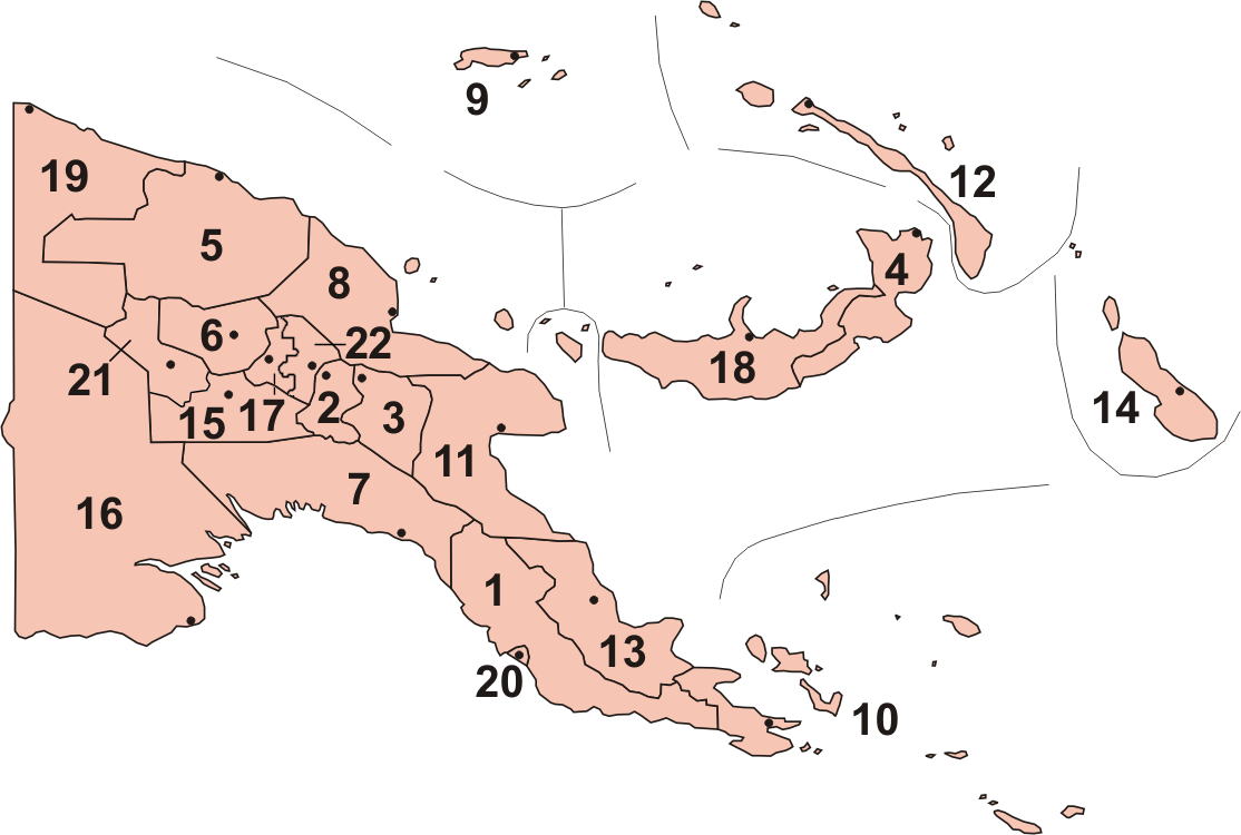
Map of Provinces of Papua New Guinea, including new provinces (Hela & Jiwaka) officially inaugurated in May 2012.
|
| Date | |
| Source | Paint Shop Pro |
| Author | Keith Edkins at English Wikipedia |
- Other information
Derived from File:Papua_new_guinea_provinces_(numbers).png by Slawojar, with reference to File:Papua New Guinea LLGs.png (public domain)
.png)
Licensing[edit]
_2012.png&action=edit§ion=2)
Keith Edkins at en.wikipedia, the copyright holder of this work, hereby publishes it under the following licenses:

|
Permission is granted to copy, distribute and/or modify this document under the terms of the GNU Free Documentation License, Version 1.2 or any later version published by the Free Software Foundation; with no Invariant Sections, no Front-Cover Texts, and no Back-Cover Texts. A copy of the license is included in the section entitled GNU Free Documentation License. |
This file is licensed under the Creative Commons Attribution-Share Alike 3.0 Unported license.
Attribution: Keith Edkins at en.wikipedia
- You are free:
- to share – to copy, distribute and transmit the work
- to remix – to adapt the work
- Under the following conditions:
- attribution – You must give appropriate credit, provide a link to the license, and indicate if changes were made. You may do so in any reasonable manner, but not in any way that suggests the licensor endorses you or your use.
- share alike – If you remix, transform, or build upon the material, you must distribute your contributions under the same or compatible license as the original.
You may select the license of your choice.
Original upload log[edit]
_2012.png&action=edit§ion=3)
The original description page was here. All following user names refer to en.wikipedia.
_2012.png)
- 2012-05-22 18:07 Keith Edkins 1114×750× (141131 bytes) Complete numbering
- 2012-05-22 18:06 Keith Edkins 1114×750× (138429 bytes) Uploading a self-made file using [[Wikipedia:File_Upload_Wizard|File Upload Wizard]]
File history
Click on a date/time to view the file as it appeared at that time.
| Date/Time | Thumbnail | Dimensions | User | Comment | |
|---|---|---|---|---|---|
| current | 18:05, 28 May 2012 | | 1,114 × 750 (138 KB) | Keith Edkins (talk | contribs) | Revised to show Anglimp in Jiwaka (whatever does that bot think it's doing, BTW?) |
| 16:50, 28 May 2012 |  | 1,114 × 750 (138 KB) | OgreBot (talk | contribs) | (BOT): Reverting to most recent version before archival | |
| 16:49, 28 May 2012 |  | 1,114 × 750 (135 KB) | OgreBot (talk | contribs) | (BOT): Uploading old version of file from en.wikipedia; originally uploaded on 2012-05-22 18:06:35 by Keith Edkins | |
| 10:08, 28 May 2012 |  | 1,114 × 750 (138 KB) | Keith Edkins (talk | contribs) | ==Summary== {{Information |Description = Map of Provinces of Papua New Guinea, including new provinces (Hela & Jiwaka) officially inaugurated in May 2012. # Central # Chimbu (Simbu... |
You cannot overwrite this file.
File usage on Commons
The following 2 pages use this file:
File usage on other wikis
The following other wikis use this file:
- Usage on af.wikipedia.org
- Usage on als.wikipedia.org
- Usage on ami.wikipedia.org
- Usage on ar.wikipedia.org
- Usage on arz.wikipedia.org
- Usage on ast.wikipedia.org
- Usage on bg.wikipedia.org
- Usage on br.wikipedia.org
- Usage on bs.wikipedia.org
- Usage on cs.wikipedia.org
- Usage on cy.wikipedia.org
- Usage on en.wikipedia.org
- Usage on eo.wikipedia.org
- Usage on eu.wikipedia.org
- Usage on fa.wikipedia.org
- Usage on fi.wikipedia.org
- Usage on fr.wikipedia.org
- Usage on ha.wikipedia.org
- Usage on he.wikipedia.org
- Usage on hu.wikipedia.org
- Usage on hy.wikipedia.org
- Usage on ia.wikipedia.org
- Usage on id.wikipedia.org
- Usage on ig.wikipedia.org
- Usage on ja.wikipedia.org
- Usage on ka.wikipedia.org
- Usage on ko.wikipedia.org
- Usage on mk.wikipedia.org
- Usage on nl.wikipedia.org
- Usage on no.wikipedia.org
View more global usage of this file.
_2012.png)
_2012.png&oldid=733002668)