File:Papua New Guinea map.png
Jump to navigation
Jump to search
No higher resolution available.
Papua_New_Guinea_map.png (322 × 346 pixels, file size: 77 KB, MIME type: image/png)
Captions
Captions
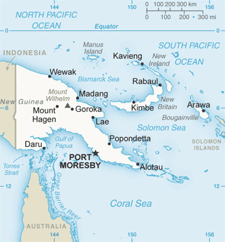
Map of Papua New Guinea

|
This map image could be re-created using vector graphics as an SVG file. This has several advantages; see Commons:Media for cleanup for more information. If an SVG form of this image is available, please upload it and afterwards replace this template with
{{vector version available|new image name}}.
It is recommended to name the SVG file “Papua New Guinea map.svg”—then the template Vector version available (or Vva) does not need the new image name parameter. |
English: Map of Papua New Guinea from CIA world fact book
This image is in the public domain because it contains materials that originally came from the United States Central Intelligence Agency's World Factbook.
|
 |
File history
Click on a date/time to view the file as it appeared at that time.
| Date/Time | Thumbnail | Dimensions | User | Comment | |
|---|---|---|---|---|---|
| current | 17:39, 21 January 2014 | | 322 × 346 (77 KB) | Andy king50 (talk | contribs) | -frame |
| 18:54, 29 August 2013 |  | 326 × 350 (447 KB) | An678ko (talk | contribs) | new - 2013 | |
| 09:29, 27 December 2005 |  | 330 × 355 (10 KB) | *drew~commonswiki (talk | contribs) | Map of Papua New Guinea from CIA world fact book {{PD-USGov-CIA-WF}} Category:Maps of Papua New Guinea |
You cannot overwrite this file.
File usage on Commons
The following 8 pages use this file:
File usage on other wikis
The following other wikis use this file:
- Usage on af.wikipedia.org
- Usage on als.wikipedia.org
- Usage on an.wikipedia.org
- Usage on ar.wikipedia.org
- Usage on arz.wikipedia.org
- Usage on ast.wikipedia.org
- Usage on avk.wikipedia.org
- Usage on az.wikipedia.org
- Usage on ba.wikipedia.org
- Usage on be-tarask.wikipedia.org
- Usage on be.wikipedia.org
- Usage on bg.wikipedia.org
- Usage on bn.wikipedia.org
- Usage on bs.wikipedia.org
- Usage on ca.wikipedia.org
- Usage on cs.wikipedia.org
- Usage on cv.wikipedia.org
- Usage on cy.wikipedia.org
- Usage on da.wikipedia.org
- Usage on de.wikipedia.org
- Usage on de.wikivoyage.org
- Usage on diq.wikipedia.org
- Usage on el.wikipedia.org
- Usage on en.wikipedia.org
View more global usage of this file.