File:Morocco Topography.png
Jump to navigation
Jump to search

Size of this preview: 687 × 600 pixels. Other resolutions: 275 × 240 pixels | 550 × 480 pixels | 880 × 768 pixels | 1,173 × 1,024 pixels | 1,774 × 1,549 pixels.
Original file (1,774 × 1,549 pixels, file size: 2.74 MB, MIME type: image/png)
Captions
Captions
Add a one-line explanation of what this file represents
Summary
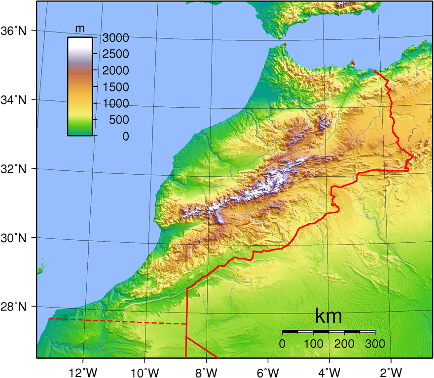
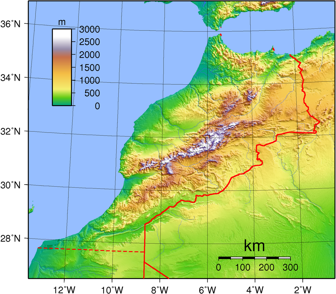
| Description | Topographic map of Morocco. Created with GMT from publicly available GLOBE data. |
| Date | |
| Source | Own work |
| Author | Sadalmelik |
Licensing
| This work has been released into the public domain by its author, I, Sadalmelik. This applies worldwide. In some countries this may not be legally possible; if so: I, Sadalmelik grants anyone the right to use this work for any purpose, without any conditions, unless such conditions are required by law. |
File history
Click on a date/time to view the file as it appeared at that time.
| Date/Time | Thumbnail | Dimensions | User | Comment | |
|---|---|---|---|---|---|
| current | 07:32, 22 November 2020 | | 1,774 × 1,549 (2.74 MB) | Christian Ferrer (talk | contribs) | it seems that is was within this version since a long time |
| 19:15, 21 November 2020 |  | 1,774 × 1,549 (1.92 MB) | Christian Ferrer (talk | contribs) | Reverted to version as of 18:52, 21 November 2020 (UTC) | |
| 18:56, 21 November 2020 |  | 1,774 × 1,549 (1.91 MB) | Taha Khattabi (talk | contribs) | Reverted to version as of 18:41, 21 November 2020 (UTC) | |
| 18:52, 21 November 2020 |  | 1,774 × 1,549 (1.92 MB) | M.Bitton (talk | contribs) | Reverted to version as of 18:20, 21 November 2020 (UTC) | |
| 18:41, 21 November 2020 |  | 1,774 × 1,549 (1.91 MB) | Taha Khattabi (talk | contribs) | Reverted to version as of 06:53, 21 November 2020 (UTC) | |
| 18:20, 21 November 2020 |  | 1,774 × 1,549 (1.92 MB) | M.Bitton (talk | contribs) | Reverted to version as of 07:43, 11 September 2013 (UTC) | |
| 06:53, 21 November 2020 |  | 1,774 × 1,549 (1.91 MB) | Taha Khattabi (talk | contribs) | There is no present border at that location, only the Berm Wall which is located south of this | |
| 06:52, 21 November 2020 |  | 1,774 × 1,549 (2.74 MB) | Taha Khattabi (talk | contribs) | Reverted to version as of 12:49, 27 December 2013 (UTC) | |
| 06:39, 21 November 2020 |  | 1,774 × 1,549 (1.91 MB) | Taha Khattabi (talk | contribs) | There is no present border at that location, only the Berm Wall which is located south of this | |
| 12:49, 27 December 2013 |  | 1,774 × 1,549 (2.74 MB) | Omar-toons (talk | contribs) | dotted line for disputed border |
You cannot overwrite this file.
File usage on Commons
The following 4 pages use this file:
File usage on other wikis
The following other wikis use this file:
- Usage on af.wikipedia.org
- Usage on ar.wikipedia.org
- Usage on ast.wikipedia.org
- Usage on avk.wikipedia.org
- Usage on bg.wikipedia.org
- Usage on bn.wikipedia.org
- Usage on br.wikipedia.org
- Usage on ca.wikipedia.org
- Usage on da.wikipedia.org
- Usage on de.wikipedia.org
- Usage on el.wikipedia.org
- Usage on en.wikipedia.org
- Usage on es.wikipedia.org
- Usage on fa.wikipedia.org
- Usage on fi.wikipedia.org
- Usage on fr.wikipedia.org
- Usage on hu.wikipedia.org
- Usage on id.wikipedia.org
- Usage on ig.wikipedia.org
- Usage on io.wikipedia.org
- Usage on it.wikipedia.org
- Usage on lt.wikipedia.org
- Usage on ms.wikipedia.org
- Usage on pl.wikipedia.org
- Usage on ro.wikipedia.org
- Usage on ru.wikipedia.org
- Usage on ru.wikimedia.org
- Usage on sr.wikipedia.org
- Usage on tr.wikipedia.org
- Usage on uk.wikipedia.org
- Usage on vec.wikipedia.org
- Usage on vep.wikipedia.org