File:Map Battle of the Nile 1798-en.png
Jump to navigation
Jump to search

Size of this preview: 415 × 599 pixels. Other resolutions: 166 × 240 pixels | 610 × 880 pixels.
Original file (610 × 880 pixels, file size: 45 KB, MIME type: image/png)
Captions
Captions
Add a one-line explanation of what this file represents

|
File:Map Battle of the Nile 1798-en.svg is a vector version of this file. It should be used in place of this PNG file when not inferior.
File:Map Battle of the Nile 1798-en.png → File:Map Battle of the Nile 1798-en.svg
For more information, see Help:SVG. |
 |
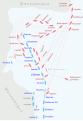
English: Map of ship positions and movements during the Battle of Aboukir Bay, August 1-2, 1798. British ships are red, French ships are blue. Intermediate ship positions are shown in pale red/blue. Based on a map from Intelligence in War, John Keegan, 2003, ISBN 0091802296
Español: Esquema táctico de la Batalla del Nilo. Se reflejan las posiciones y los movimientos de los barcos en esta batalla. Los buques ingleses están en rojo y los franceses en azul. Basándose en un mapa de inteligencia de John Keegan, 2003, ISBN 0091802296.
Other versions: []
-
 English
 -
 English (PNG original)
 -
 español
 -
 français
 -
 magyar
 -
 русский
 -
 Deutsch


| This work has been released into the public domain by its author, Gsl. This applies worldwide. In some countries this may not be legally possible; if so: |
File history
Click on a date/time to view the file as it appeared at that time.
| Date/Time | Thumbnail | Dimensions | User | Comment | |
|---|---|---|---|---|---|
| current | 09:01, 10 January 2006 | | 610 × 880 (45 KB) | Gsl~commonswiki (talk | contribs) | 3rd version: made serieuse frigate-sized, fixed line order of last four british ships |
| 08:59, 10 January 2006 |  | 600 × 880 (47 KB) | Gsl~commonswiki (talk | contribs) | 2nd version: rotated so north is top, added missing ships, initial ship positions | |
| 08:57, 10 January 2006 |  | 680 × 700 (42 KB) | Gsl~commonswiki (talk | contribs) | original version from en.wikipedia.org |
You cannot overwrite this file.
File usage on Commons
The following 11 pages use this file:
- User:とある白い猫/List/Sources/03
- File:Battle of Aboukir Bay.png (file redirect)
- File:Map Battle of the Nile 1798-de.svg
- File:Map Battle of the Nile 1798-en.png
- File:Map Battle of the Nile 1798-en.svg
- File:Map Battle of the Nile 1798-es.svg
- File:Map Battle of the Nile 1798-fr.svg
- File:Map Battle of the Nile 1798-hu.svg
- File:Map Battle of the Nile 1798-ru.svg
- Template:Other versions/Map Battle of the Nile 1798
File usage on other wikis
The following other wikis use this file:
- Usage on af.wikipedia.org
- Usage on ar.wikipedia.org
- Usage on az.wikipedia.org
- Usage on ca.wikipedia.org
- Usage on cs.wikipedia.org
- Usage on el.wikipedia.org
- Usage on eo.wikipedia.org
- Usage on es.wikipedia.org
- Usage on fr.wikipedia.org
- Usage on he.wikipedia.org
- Usage on it.wikipedia.org
- Usage on ja.wikipedia.org
- Usage on ko.wikipedia.org
- Usage on no.wikipedia.org
- Usage on pl.wikipedia.org
- Usage on pt.wikipedia.org
- Usage on ro.wikipedia.org
- Usage on tr.wikipedia.org
- Usage on vi.wikipedia.org
- Usage on zh.wikipedia.org