File:Karte der Provinzen (Niederlande) - nl.svg
Jump to navigation
Jump to search

Size of this PNG preview of this SVG file: 506 × 600 pixels. Other resolutions: 202 × 240 pixels | 405 × 480 pixels | 648 × 768 pixels | 864 × 1,024 pixels | 1,727 × 2,048 pixels | 743 × 881 pixels.
Original file (SVG file, nominally 743 × 881 pixels, file size: 1.54 MB)
Captions
Captions
Add a one-line explanation of what this file represents
Summary[edit]
_-_nl.svg&action=edit§ion=1)
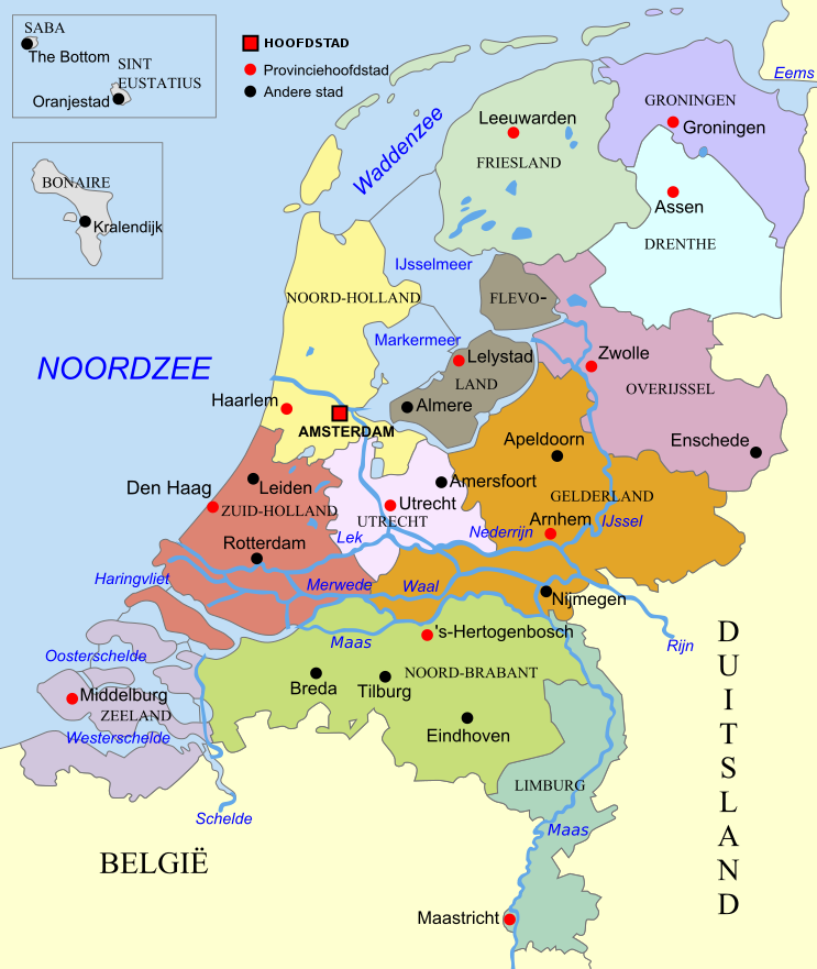
| Description | SVG kaart van Nederland met Provincies |
| Date | |
| Source | Own work |
| Author | Hans Erren |
| Other versions | derived from file:Karte der Provinzen (Niederlande).svg |
.svg)
Licensing[edit]
_-_nl.svg&action=edit§ion=2)
I, the copyright holder of this work, hereby publish it under the following license:
This file is licensed under the Creative Commons Attribution-Share Alike 3.0 Unported license.
- You are free:
- to share – to copy, distribute and transmit the work
- to remix – to adapt the work
- Under the following conditions:
- attribution – You must give appropriate credit, provide a link to the license, and indicate if changes were made. You may do so in any reasonable manner, but not in any way that suggests the licensor endorses you or your use.
- share alike – If you remix, transform, or build upon the material, you must distribute your contributions under the same or compatible license as the original.
File history
Click on a date/time to view the file as it appeared at that time.
| Date/Time | Thumbnail | Dimensions | User | Comment | |
|---|---|---|---|---|---|
| current | 19:10, 21 September 2020 | | 743 × 881 (1.54 MB) | Hans Erren (talk | contribs) | update revised boundary prov. Utrecht 2019 |
| 20:50, 28 December 2012 |  | 743 × 881 (1.54 MB) | Hans Erren (talk | contribs) | {{Information |Description ={{en|1=SVG kaart van Nederland met Provincies}} |Source ={{own}} |Author =Hans Erren |Date = |Permission = |other_versions = }} | |
| 14:57, 15 December 2012 |  | 743 × 881 (1.56 MB) | Hans Erren (talk | contribs) | {{Information |Description ={{en|1=SVG map of the netherlands with provinces}} |Source ={{own}} |Author =Hans Erren |Date =1012-12-15 |Permission = |other_versions =derived from [[:file:Karte der Pro... | |
| 20:29, 9 December 2012 |  | 743 × 881 (1.62 MB) | Hans Erren (talk | contribs) | {{Information |Description ={{nl|1=SVG kaart van Nederland met Provincies}} |Source =Own work |Author =Hans Erren |Date =2012-12-09 |Permission = |other_versions =derived from [[:file:Karte der Provi... | |
| 20:09, 9 December 2012 |  | 743 × 881 (1.52 MB) | Hans Erren (talk | contribs) | {{Information |Description= SVG kaart van Nederland met Provincies |Source={{own}} |Date= |Author= Hans Erren |Permission= |other_versions= derived from file:Karte der Provinzen (Niederlande).svg }} [[Category:SVG maps of the ... |
You cannot overwrite this file.
File usage on Commons
There are no pages that use this file.
File usage on other wikis
The following other wikis use this file:
- Usage on af.wikipedia.org
- Usage on nl.wikipedia.org
- Usage on qu.wikipedia.org
- Usage on vi.wikipedia.org
- Usage on zh-yue.wikipedia.org
_-_nl.svg&oldid=761830047)