File:Hu-map.png
Jump to navigation
Jump to search
No higher resolution available.
Hu-map.png (635 × 325 pixels, file size: 17 KB, MIME type: image/png)
Captions
Captions
Add a one-line explanation of what this file represents
| Description |
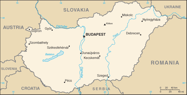
English: CIA political map of Hungary
Español: Mapa de Hungría político de la CIA |
|||
| Source | CIA World Factbook | |||
| Author | CIA | |||
| Permission (Reusing this file) |
|
|||
| Other versions |
Derivative works of this file: Ungheriait.png Image:Hu-map-sl.png (Slovene version) |

File history
Click on a date/time to view the file as it appeared at that time.
| Date/Time | Thumbnail | Dimensions | User | Comment | |
|---|---|---|---|---|---|
| current | 00:56, 9 July 2007 | | 635 × 325 (17 KB) | Aivazovsky~commonswiki (talk | contribs) | |
| 20:00, 5 March 2005 |  | 635 × 324 (15 KB) | Alfio (talk | contribs) | CIA map of Hungary |
You cannot overwrite this file.
File usage on Commons
The following 5 pages use this file:
File usage on other wikis
The following other wikis use this file:
- Usage on af.wikipedia.org
- Usage on als.wikipedia.org
- Usage on ast.wikipedia.org
- Usage on ay.wikipedia.org
- Usage on azb.wikipedia.org
- Usage on bg.wiktionary.org
- Usage on bn.wikipedia.org
- Usage on cs.wikinews.org
- Usage on da.wikipedia.org
- Usage on de.wikipedia.org
- Usage on en.wikipedia.org
- Usage on en.wiktionary.org
- Usage on gag.wikipedia.org
- Usage on gl.wikipedia.org
- Usage on hu.wikipedia.org
- Usage on hu.wikibooks.org
- Usage on hu.wiktionary.org
- Usage on id.wikipedia.org
- Usage on it.wikinews.org
- Usage on it.wiktionary.org
- Usage on ko.wiktionary.org
- Usage on lfn.wikipedia.org
- Usage on lt.wiktionary.org
- Usage on mr.wikipedia.org
- Usage on nl.wikipedia.org
- Usage on nl.wiktionary.org
- Usage on no.wikipedia.org
- Usage on pl.wikivoyage.org
- Usage on pt.wikipedia.org
- Usage on pt.wikivoyage.org
- Usage on qu.wikipedia.org
- Usage on rm.wikipedia.org
- Usage on ru.wikipedia.org
- Usage on sq.wikipedia.org
- Usage on sr.wikipedia.org
- Usage on su.wikipedia.org
- Usage on tr.wiktionary.org
- Usage on udm.wikipedia.org
- Usage on uz.wikipedia.org
View more global usage of this file.