File:Guyana-CIA WFB Map.png
Jump to navigation
Jump to search
No higher resolution available.
Guyana-CIA_WFB_Map.png (329 × 353 pixels, file size: 17 KB, MIME type: image/png)
Captions
Captions
Add a one-line explanation of what this file represents
Summary[edit]
| Description |
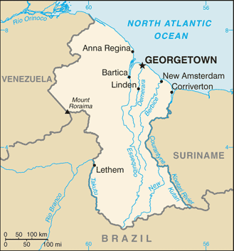
English: Map of Guyana.
Français : Carte du Guyana.
Italiano: Mappa della Guyana. |
|||
| Date | ||||
| Source | https://www.cia.gov/the-world-factbook/static/maps/GY-map.jpg | |||
| Author | Directorate of Intelligence, CIA | |||
| Permission (Reusing this file) |
|
|||
| Other versions |
|


File history
Click on a date/time to view the file as it appeared at that time.
| Date/Time | Thumbnail | Dimensions | User | Comment | |
|---|---|---|---|---|---|
| current | 08:02, 21 July 2007 | | 329 × 353 (17 KB) | Hoshie (talk | contribs) | Updated map of Guyana from the CIA World Factbook, 14 June 07 rev. Src: https://www.cia.gov/library/publications/the-world-factbook/maps/gy-map.gif |
| 09:14, 27 March 2005 |  | 329 × 706 (10 KB) | Wolfman~commonswiki (talk | contribs) | {{CIA-map}} |
You cannot overwrite this file.
File usage on Commons
The following 5 pages use this file:
File usage on other wikis
The following other wikis use this file:
- Usage on af.wikipedia.org
- Usage on be-tarask.wikipedia.org
- Usage on de.wikipedia.org
- Usage on de.wiktionary.org
- Usage on dsb.wikipedia.org
- Usage on en.wikipedia.org
- Usage on en.wikinews.org
- Usage on en.wikisource.org
- Usage on eo.wikipedia.org
- Usage on es.wikipedia.org
- Usage on fa.wikipedia.org
- Usage on fi.wikipedia.org
- Usage on frr.wikipedia.org
- Usage on fy.wikipedia.org
- Usage on gom.wikipedia.org
- Usage on hi.wikipedia.org
- Usage on hr.wikipedia.org
- Usage on hu.wikipedia.org
- Usage on it.wikipedia.org
- Usage on ja.wikipedia.org
- Usage on kn.wikipedia.org
- Usage on la.wikipedia.org
- Usage on lb.wikipedia.org
- Usage on lfn.wikipedia.org
- Usage on lld.wikipedia.org
- Usage on lt.wiktionary.org
- Usage on ml.wikipedia.org
View more global usage of this file.