File:Confederate States of America.svg
Jump to navigation
Jump to search

Size of this PNG preview of this SVG file: 800 × 501 pixels. Other resolutions: 320 × 200 pixels | 640 × 401 pixels | 1,024 × 642 pixels | 1,280 × 802 pixels | 2,560 × 1,604 pixels | 913 × 572 pixels.
Original file (Animated SVG file, nominally 913 × 572 pixels, file size: 57 KB)
Note: Due to technical limitations, thumbnails of this file will not be animated.
Captions
Captions
Add a one-line explanation of what this file represents
Summary[edit]
| Description |
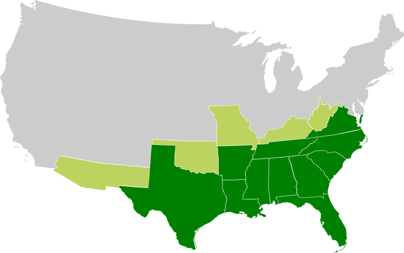
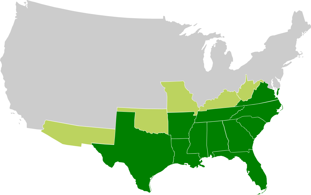
A map of the Confederate States of America, Maryland and claimed states and territories.
States that seceeded under CSA control
States and territories claimed by CSA without formal secession and/or control |
| Date | |
| Source | Own work |
| Author |
|
| Other versions | File:Csa5-3.gif |
Licensing[edit]
This file is licensed under the Creative Commons Attribution-Share Alike 3.0 Unported license.
- You are free:
- to share – to copy, distribute and transmit the work
- to remix – to adapt the work
- Under the following conditions:
- attribution – You must give appropriate credit, provide a link to the license, and indicate if changes were made. You may do so in any reasonable manner, but not in any way that suggests the licensor endorses you or your use.
- share alike – If you remix, transform, or build upon the material, you must distribute your contributions under the same or compatible license as the original.
File history
Click on a date/time to view the file as it appeared at that time.
| Date/Time | Thumbnail | Dimensions | User | Comment | |
|---|---|---|---|---|---|
| current | 16:23, 27 November 2009 | | 913 × 572 (57 KB) | Lexicon (talk | contribs) | Reverted to version as of 08:57, 21 March 2008 as new version is different image used for different purposes, and not an SVG file |
| 00:56, 26 November 2009 |  | 640 × 419 (34 KB) | Major General Sterling Price (talk | contribs) | this is the Confederate States today if they won the Civil War | |
| 08:57, 21 March 2008 |  | 913 × 572 (57 KB) | Nkocharh (talk | contribs) | I forgot Kentucky! | |
| 08:49, 21 March 2008 |  | 913 × 572 (55 KB) | Nkocharh (talk | contribs) | {{Information |Description=A map of the Confederate Sates of America |Source=self-made |Date=21 March 2008 |Author= Nkocharh |Permission= |other_versions= }} |
You cannot overwrite this file.
File usage on Commons
There are no pages that use this file.
File usage on other wikis
The following other wikis use this file:
- Usage on af.wikipedia.org
- Usage on arz.wikipedia.org
- Usage on bn.wikipedia.org
- Usage on br.wikipedia.org
- Usage on da.wikipedia.org
- Usage on de.wikipedia.org
- Usage on el.wikipedia.org
- Usage on en.wikipedia.org
- Alabama
- Arkansas
- Confederate States of America
- Louisiana
- North Carolina
- South Carolina
- Texas
- Tennessee
- Virginia
- West Virginia
- Georgia (U.S. state)
- Confederate Arizona
- West Virginia in the American Civil War
- User:Nkocharh
- Missouri in the American Civil War
- Florida in the American Civil War
- Kentucky in the American Civil War
- Alabama in the American Civil War
- Mississippi in the American Civil War
- South Carolina in the American Civil War
- Tennessee in the American Civil War
- Texas in the American Civil War
- Georgia in the American Civil War
- North Carolina in the American Civil War
- Virginia in the American Civil War
- Template:Confederate States political divisions
- Arkansas in the American Civil War
- Louisiana in the American Civil War
- Confederate government of Kentucky
- Wikipedia:Graphics Lab/Images to improve/Archive/Mar 2008
- Mississippi
- Secession in the United States
- Florida
- Conclusion of the American Civil War
- 1861 in the United States
- Talk:Muscogee Nation
- Confederate government of Missouri
View more global usage of this file.