File:AntarcticaRockSurface.jpg
Jump to navigation
Jump to search
Size of this preview: 600 × 600 pixels. Other resolutions: 240 × 240 pixels | 480 × 480 pixels.
Original file (800 × 800 pixels, file size: 356 KB, MIME type: image/jpeg)
Captions
Captions
Add a one-line explanation of what this file represents
Summary[edit]
| Description |
Català: L'Antàrtida sense glaç. En aquest mapa no es pren en consideració que el nivell del mar augmentaria degut al desgel. De la mateixa manera, tampoc es considera que la massa geològica també ho faria en uns centenars de metres en un període de desenes de milers d'anys degut a la desaparició de la potent pressió provocada per la immensa capa de glaç.
Deutsch: Antarktika ohne Eis. Berücksichtigt sind hier weder der durch die Eisschmelze bedingte Anstieg des Meeresspiegels noch die langfristige Anhebung der Kontinentalmasse durch das wegfallende Gewicht.
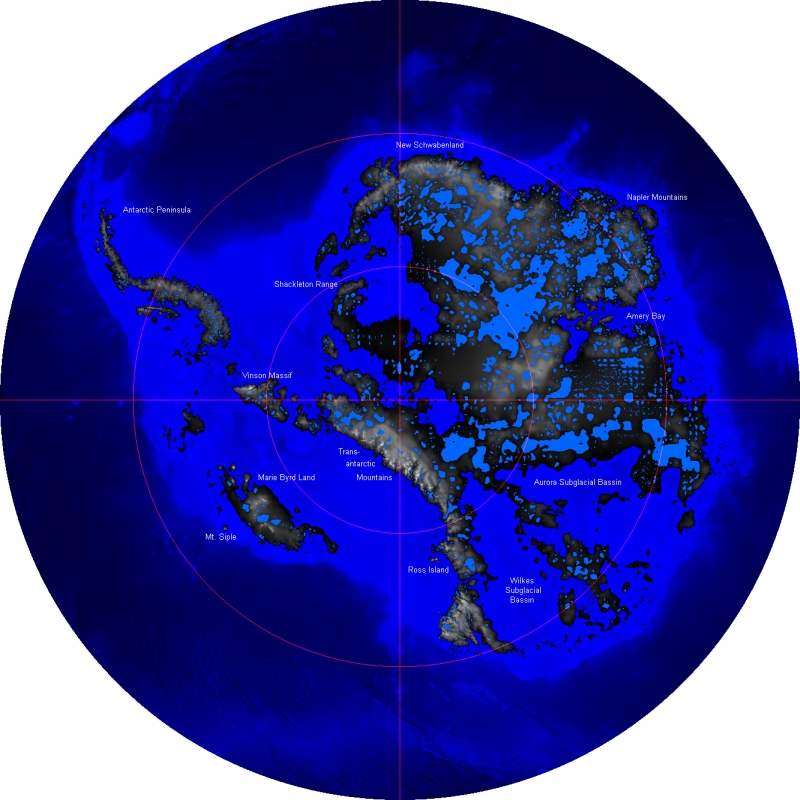
English: Rock surface of Antarctica and sea ground without its ice-shield, from 60 to 90 degrees South. This map does not consider that sea level would rise because of the melted ice, nor that the landmass would rise by several hundred meters over a few tens of thousands of years after the weight of the ice was no longer depressing the landmass.
Polski: Powierzchnia Antarktydy bez lodu. Mapa nie uwzględnia wzrostu poziomu morza po stopieniu lądolodu i następującego, po zniknięciu jego ciężaru, wynurzania się kontynentu
Português: A Antártica sem sua cobertura de gelo, desde 60 até 90 graus de latitude sul. Esse mapa não considera que o nível do mar se elevaria pelo derretimento do gelo, nem que a massa do continente se elevaria em várias centenas de metros num período de algumas dezenas de milhares de anos, ao desaparecer o peso da massa de gelo sobre a rocha.
Español: La Antartida sin hielo.En este mapa no se tiene en consideración que el nivel del mar aumentaria debido al deshielo.De la misma manera, tampoco se considera que la masa geologica tambien lo haria en unos cientos de metros en un periodo de decenas de miles de años debido a la desaparicion de la potente presión provocada por la inmensa capa de hielo |
| Date | |
| Source | Own model based on data provided by BEDMAP Consortium, available at http://www.antarctica.ac.uk/bas_research/data/access/bedmap/download/ (20 March 2006) |
| Author |
Licensing[edit]
| I, the copyright holder of this work, release this work into the public domain. This applies worldwide. In some countries this may not be legally possible; if so: I grant anyone the right to use this work for any purpose, without any conditions, unless such conditions are required by law. |
File history
Click on a date/time to view the file as it appeared at that time.
| Date/Time | Thumbnail | Dimensions | User | Comment | |
|---|---|---|---|---|---|
| current | 10:58, 20 March 2006 | | 800 × 800 (356 KB) | Panda17 (talk | contribs) | {{Information| |Description = Rock surface of Antarctica and sea ground, from 60 to 90 degrees South. |Source = Own model based on data provided by BEDMAP Consortium, available at http://www.antarctica.ac.uk/aedc/bedmap/download/ (20 March 2006) |Date = 2 |
You cannot overwrite this file.
File usage on Commons
The following page uses this file:
File usage on other wikis
The following other wikis use this file:
- Usage on af.wikipedia.org
- Usage on ar.wikipedia.org
- Usage on az.wikipedia.org
- Usage on be.wikipedia.org
- Usage on bg.wikipedia.org
- Usage on ceb.wikipedia.org
- Usage on ce.wikipedia.org
- Usage on de.wikipedia.org
- Usage on en.wikipedia.org
- Usage on es.wikipedia.org
- Usage on fa.wikipedia.org
- Usage on fi.wikipedia.org
- Usage on ja.wikipedia.org
- Usage on mk.wikipedia.org
- Usage on ms.wikipedia.org
- Usage on mwl.wikipedia.org
- Usage on nn.wikipedia.org
- Usage on no.wikipedia.org
- Usage on pt.wikipedia.org
- Usage on ru.wikipedia.org
- Usage on uk.wikipedia.org
- Usage on www.wikidata.org