File:Anglospeak-proficiency.svg

Original file (SVG file, nominally 841 × 426 pixels, file size: 1.49 MB)
Captions
Captions
Summary[edit]
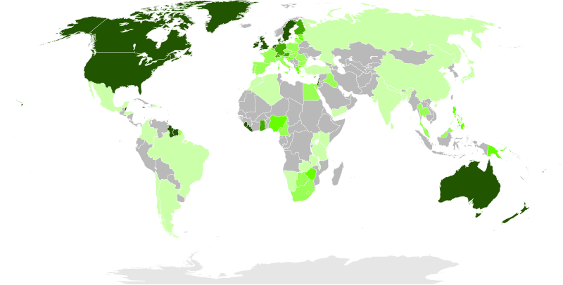
World map colored according to proficiency of tested English speakers by country. See png for source/methodology.
Other versions:
Licensing[edit]

|
Permission is granted to copy, distribute and/or modify this document under the terms of the GNU Free Documentation License, Version 1.2 or any later version published by the Free Software Foundation; with no Invariant Sections, no Front-Cover Texts, and no Back-Cover Texts. A copy of the license is included in the section entitled GNU Free Documentation License.http://www.gnu.org/copyleft/fdl.htmlGFDLGNU Free Documentation Licensetruetrue |
- You are free:
- to share – to copy, distribute and transmit the work
- to remix – to adapt the work
- Under the following conditions:
- attribution – You must give appropriate credit, provide a link to the license, and indicate if changes were made. You may do so in any reasonable manner, but not in any way that suggests the licensor endorses you or your use.
- share alike – If you remix, transform, or build upon the material, you must distribute your contributions under the same or compatible license as the original.
File history
Click on a date/time to view the file as it appeared at that time.
| Date/Time | Thumbnail | Dimensions | User | Comment | |
|---|---|---|---|---|---|
| current | 06:29, 24 February 2016 |  | 841 × 426 (1.49 MB) | BurritoBazooka (talk | contribs) | add total white background |
| 06:25, 24 February 2016 |  | 841 × 426 (1.49 MB) | BurritoBazooka (talk | contribs) | delete messed up ocean layer (Alaska is still on the surface of the planet, last time I checked) | |
| 21:07, 14 May 2015 |  | 855 × 440 (1.5 MB) | Elianfoo (talk | contribs) | No sources exist for Norway, Iceland, Macedonia, Bosnia and Herzegovina, changed colors for these to gray. Added Brazil, Argentina, Chile, and Egypt, Morocco, Algeria and updated colors for Germany, Austria, and others | |
| 13:40, 11 November 2011 |  | 855 × 440 (1.5 MB) | Elianfoo (talk | contribs) | Added Guyana, updated color for India, and changed color of Norway to grey as the percentage is unsourced. | |
| 05:09, 21 July 2011 |  | 855 × 440 (1.5 MB) | J intela (talk | contribs) | Added Lebenon, Israel, and Palistine. | |
| 04:55, 21 July 2011 |  | 855 × 440 (1.5 MB) | J intela (talk | contribs) | Added countries, filled in blank spaces. | |
| 04:53, 21 July 2011 |  | 855 × 440 (1.5 MB) | J intela (talk | contribs) | Added countries, filled in blank spaces. | |
| 23:32, 23 December 2010 |  | 855 × 440 (1.5 MB) | MacedonianBoy (talk | contribs) | small | |
| 22:13, 14 October 2010 |  | 855 × 440 (1.5 MB) | Elianfoo (talk | contribs) | Crop to image | |
| 21:55, 14 October 2010 |  | 744 × 1,052 (1.49 MB) | Elianfoo (talk | contribs) | World map colored according to percentage of English speakers by country, see http://en.wikipedia.org/wiki/List_of_countries_by_English-speaking_population Dark green, 225500: 80-100% Green, 44aa00: 60-80% Green, 66ff00: 40-60% Green, 99ff55: 20-40% Lig |
You cannot overwrite this file.
File usage on Commons
The following 3 pages use this file:
File usage on other wikis
The following other wikis use this file:
- Usage on ast.wikipedia.org
- Usage on en.wikipedia.org
- Usage on meta.wikimedia.org
- Usage on ro.wikipedia.org
Metadata
This file contains additional information such as Exif metadata which may have been added by the digital camera, scanner, or software program used to create or digitize it. If the file has been modified from its original state, some details such as the timestamp may not fully reflect those of the original file. The timestamp is only as accurate as the clock in the camera, and it may be completely wrong.
| Width | 840.56451 |
|---|---|
| Height | 425.80997 |
