File:Altimetria Italia.svg
Jump to navigation
Jump to search

Size of this PNG preview of this SVG file: 600 × 600 pixels. Other resolutions: 240 × 240 pixels | 480 × 480 pixels | 768 × 768 pixels | 1,024 × 1,024 pixels | 2,048 × 2,048 pixels | 700 × 700 pixels.
Original file (SVG file, nominally 700 × 700 pixels, file size: 29 KB)
Captions
Captions
Add a one-line explanation of what this file represents
| Description |
|
| Date | |
| Source | Own work |
| Author | Luigi Chiesa |
| Permission (Reusing this file) |
Own work, all rights released (Public domain) |
| Other versions |
|

| I, the copyright holder of this work, release this work into the public domain. This applies worldwide. In some countries this may not be legally possible; if so: I grant anyone the right to use this work for any purpose, without any conditions, unless such conditions are required by law. |
File history
Click on a date/time to view the file as it appeared at that time.
| Date/Time | Thumbnail | Dimensions | User | Comment | |
|---|---|---|---|---|---|
| current | 12:30, 30 December 2012 | | 700 × 700 (29 KB) | Guybrush Threepwood (talk | contribs) | {{it|1=spearatore corretto}} |
| 21:22, 9 April 2008 |  | 700 × 700 (29 KB) | Luigi Chiesa (talk | contribs) | Corretto valore errato | |
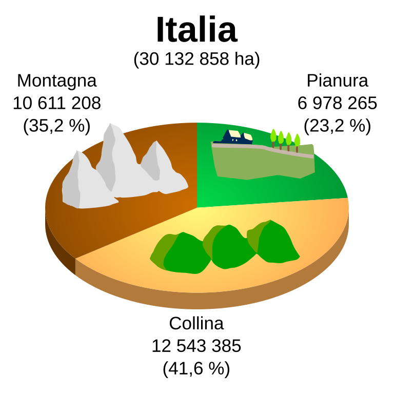
| 21:10, 16 March 2008 |  | 700 × 700 (29 KB) | Luigi Chiesa (talk | contribs) | {{Information |Description=*{{it|Ripartizione del territorio italiano per aree altimetriche}} |Source=self-made |Date=2008-03-16 |Author=Luigi Chiesa |Permission=Own work, all rights released (Public domain) |other_versions= }} {{PD |
You cannot overwrite this file.
File usage on Commons
The following 2 pages use this file:
File usage on other wikis
The following other wikis use this file:
- Usage on af.wikipedia.org
- Usage on eo.wikipedia.org
- Usage on eu.wikipedia.org
- Usage on fr.wikipedia.org
- Usage on it.wikipedia.org
- Usage on vec.wikipedia.org