File:African nations order of independence 1950-1993.gif
Jump to navigation
Jump to search
No higher resolution available.
African_nations_order_of_independence_1950-1993.gif (450 × 355 pixels, file size: 16 KB, MIME type: image/gif, looped, 50 frames, 54 s)
Captions
Captions
Add a one-line explanation of what this file represents
Summary[edit]
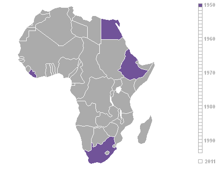
| Description | Order of independence of African nations 1950-1993, as listed on List of countries by date of nationhood. Made in photoshop from various historical maps on wikipedia all based on Vardion's Image:BlankMap-World.png |
| Date | 1 August 2006 (original upload date) |
| Source | No machine-readable source provided. Own work assumed (based on copyright claims). |
| Author | No machine-readable author provided. Roke~commonswiki assumed (based on copyright claims). |
Licensing[edit]
I, the copyright holder of this work, hereby publish it under the following license:

|
Permission is granted to copy, distribute and/or modify this document under the terms of the GNU Free Documentation License, Version 1.2 or any later version published by the Free Software Foundation; with no Invariant Sections, no Front-Cover Texts, and no Back-Cover Texts. A copy of the license is included in the section entitled GNU Free Documentation License. |
| This file is licensed under the Creative Commons Attribution-Share Alike 3.0 Unported license. | ||
| ||
| This licensing tag was added to this file as part of the GFDL licensing update. |
| Annotations | This image is annotated: View the annotations at Commons |
File history
Click on a date/time to view the file as it appeared at that time.
| Date/Time | Thumbnail | Dimensions | User | Comment | |
|---|---|---|---|---|---|
| current | 13:05, 20 January 2013 | | 450 × 355 (16 KB) | ArnoldPlaton (talk | contribs) | Added South Sudan |
| 04:58, 1 August 2006 |  | 450 × 355 (15 KB) | Roke~commonswiki (talk | contribs) | Order of independence of African nations 1950-1993, as listed on List of countries by date of nationhood. Made in photoshop from various historical maps on wikipedia all based on Vardion's [[:Image:BlankMap-Wo |
You cannot overwrite this file.
File usage on Commons
The following 2 pages use this file:
- Atlas of Africa
- File:Africa.gif (file redirect)
File usage on other wikis
The following other wikis use this file:
- Usage on af.wikipedia.org
- Usage on anp.wikipedia.org
- Usage on ar.wikipedia.org
- Usage on ast.wikipedia.org
- Usage on azb.wikipedia.org
- Usage on bg.wikipedia.org
- Usage on ca.wikipedia.org
- Usage on cs.wikipedia.org
- Usage on cs.wikinews.org
- Usage on de.wikipedia.org
- Usage on diq.wikipedia.org
- Usage on el.wikipedia.org
- Usage on en.wikipedia.org
- Usage on en.wikiquote.org
- Usage on eo.wikipedia.org
- Usage on es.wikipedia.org
- Usage on eu.wikipedia.org
- Usage on fa.wikipedia.org
- Usage on fi.wikipedia.org
- Usage on fr.wikipedia.org
- Usage on gl.wikipedia.org
- Usage on ha.wikipedia.org
- Usage on he.wikipedia.org
- Usage on hi.wikipedia.org
- Usage on hu.wikipedia.org
- Usage on id.wikipedia.org
- Usage on ka.wikipedia.org
- Usage on ko.wikipedia.org
- Usage on lb.wikipedia.org
View more global usage of this file.