File:1973 NATO and WP troop strengths in Europe.svg
Jump to navigation
Jump to search

Size of this PNG preview of this SVG file: 570 × 600 pixels. Other resolutions: 228 × 240 pixels | 456 × 480 pixels | 730 × 768 pixels | 973 × 1,024 pixels | 1,947 × 2,048 pixels | 655 × 689 pixels.
Original file (SVG file, nominally 655 × 689 pixels, file size: 299 KB)
Captions
Captions
Add a one-line explanation of what this file represents
Summary[edit]
| Description |
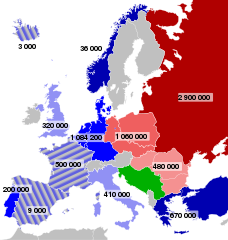
Deutsch: Truppenstärke der NATO-Mitgliedsstaaten in Europa und der Staaten des Warschauer Paktes 1973.
English: Troop strengths of NATO members in Europe, and of Warsaw Pact members, 1973.
Français : Effectifs militaires en Europe durant la guerre froide, en 1973.
|
| Date |
|
| Source | Own work based on: Iron Curtain map.svg and EuropaNATOWP1959.png |
| Author |
Sémhur |
| Other versions |
|
| SVG development |

| Object location | | View this and other nearby images on: OpenStreetMap |
|---|
Licensing[edit]
This file is licensed under the Creative Commons Attribution-Share Alike 3.0 Unported license.
- You are free:
- to share – to copy, distribute and transmit the work
- to remix – to adapt the work
- Under the following conditions:
- attribution – You must give appropriate credit, provide a link to the license, and indicate if changes were made. You may do so in any reasonable manner, but not in any way that suggests the licensor endorses you or your use.
- share alike – If you remix, transform, or build upon the material, you must distribute your contributions under the same or compatible license as the original.
Original upload log[edit]
This image is a derivative work of the following images:
- File:Iron_Curtain_map.svg licensed with Cc-by-sa-3.0,2.5,2.0,1.0, Cc-by-sa-3.0,2.5,2.0,1.0/fr, GFDL, GFDL/fr
- 2008-09-27T16:57:08Z Sémhur 645x690 (328759 Bytes) Correcting mistake : Austria wasn't in NATO.
- 2008-05-31T10:51:12Z Sémhur 645x690 (337557 Bytes) {{Information |Description={{en|1=Map of the [[:en:Iron Curtain|Iron Curtain]] in Europe.}} {{fr|1=Carte du [[:fr:Rideau de fer|rideau de fer]] en Europe.}} {{es|1=Mapa del [[:es:Telón de Acero|Telón de Acero]] en Europa.}}
- File:EuropaNATOWP1973.png licensed with Cc-by-sa-3.0-migrated, GFDL
- 2007-05-13T09:21:44Z Wikifreund 1165x1200 (360894 Bytes) {{Information |Description=Truppenstärke der NATO-Mitgliedsstaaten in Europa und der Staaten des Warschauer Paktes Anfang 1973. Truppenstärke der NATO-Staaten inkl. Kontingente aus den USA und Kanada. Miteingerechnet wurden
Uploaded with derivativeFX
File history
Click on a date/time to view the file as it appeared at that time.
| Date/Time | Thumbnail | Dimensions | User | Comment | |
|---|---|---|---|---|---|
| current | 13:40, 3 September 2021 | | 655 × 689 (299 KB) | Darafsh (talk | contribs) | File uploaded using svgtranslate tool (https://svgtranslate.toolforge.org/). Added translation for fa. |
| 06:09, 16 July 2013 |  | 655 × 689 (293 KB) | Citypeek (talk | contribs) | Corrected error in file. Valid SVG now. | |
| 09:22, 4 January 2010 |  | 655 × 689 (293 KB) | Sémhur (talk | contribs) | == {{int:filedesc}} == {{Information |Description= {{de|1=Truppenstärke der NATO-Mitgliedsstaaten in Europa und der Staaten des Warschauer Paktes 1973.}} {{en|1=Troop strengths of NATO members in Europe, and of Warsaw Pact members, 1973.}} {{fr|1=Effecti |
You cannot overwrite this file.
File usage on Commons
The following 2 pages use this file:
File usage on other wikis
The following other wikis use this file:
- Usage on af.wikipedia.org
- Usage on azb.wikipedia.org
- Usage on en.wikipedia.org
- Usage on fr.wikipedia.org
- Usage on id.wikipedia.org
- Usage on it.wikipedia.org
- Usage on pt.wikipedia.org
- Usage on ro.wikipedia.org
- Usage on ru.wikipedia.org
- Usage on su.wikipedia.org
- Usage on zh.wikipedia.org