File:Java Topography.png
Jump to navigation
Jump to search

Size of this preview: 800 × 504 pixels. Other resolutions: 320 × 202 pixels | 640 × 403 pixels | 1,024 × 645 pixels | 1,280 × 806 pixels | 2,688 × 1,693 pixels.
Original file (2,688 × 1,693 pixels, file size: 1.16 MB, MIME type: image/png)
Captions
Captions
Java, Indonesia
Summary[edit]
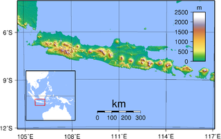
| Description | Topography of Java. Created with GMT from publicly released SRTM data. For locator version, see Image:Java Locator Topography.png |
| Date | |
| Source | Own work |
| Author | Sadalmelik |
Licensing[edit]
| I, the copyright holder of this work, release this work into the public domain. This applies worldwide. In some countries this may not be legally possible; if so: I grant anyone the right to use this work for any purpose, without any conditions, unless such conditions are required by law. |
File history
Click on a date/time to view the file as it appeared at that time.
| Date/Time | Thumbnail | Dimensions | User | Comment | |
|---|---|---|---|---|---|
| current | 18:45, 30 August 2007 | | 2,688 × 1,693 (1.16 MB) | Sadalmelik (talk | contribs) | {{Information |Description=Topography of Java. Created with GMT from publicly released SRTM data. |Source=self-made |Date=30 Aug, 2007 |Author= Sadalmelik }} Category:Maps of Indonesia Category:Topographic maps of Asia |
You cannot overwrite this file.
File usage on Commons
More than 100 pages use this file. The following list shows the first 100 pages that use this file only. A full list is available.
- User:Sadalmelik
- File:Восточная Ява.png
- File:Провинции Явы.png
- File:Физ. карта Явы.png
- Template:Javayear
- Category:1619 in Java
- Category:1677 in Java
- Category:1678 in Java
- Category:1781 in Java
- Category:1859 in Java
- Category:1865 in Java
- Category:1867 in Java
- Category:1870 in Java
- Category:1873 in Java
- Category:1876 in Java
- Category:1880 in Java
- Category:1884 in Java
- Category:1885 in Java
- Category:1888 in Java
- Category:1889 in Java
- Category:1890 in Java
- Category:1891 in Java
- Category:1893 in Java
- Category:1895 in Java
- Category:1896 in Java
- Category:1897 in Java
- Category:1898 in Java
- Category:1900 in Java
- Category:1901 in Java
- Category:1902 in Java
- Category:1904 in Java
- Category:1905 in Java
- Category:1907 in Java
- Category:1908 in Java
- Category:1909 in Java
- Category:1910 in Java
- Category:1911 in Java
- Category:1912 in Java
- Category:1913 in Java
- Category:1914 in Java
- Category:1915 in Java
- Category:1916 in Java
- Category:1917 in Java
- Category:1918 in Java
- Category:1919 in Java
- Category:1920 in Java
- Category:1921 in Java
- Category:1922 in Java
- Category:1923 in Java
- Category:1924 in Java
- Category:1925 in Java
- Category:1926 in Java
- Category:1927 in Java
- Category:1928 in Java
- Category:1929 in Java
- Category:1930 in Java
- Category:1931 in Java
- Category:1932 in Java
- Category:1933 in Java
- Category:1934 in Java
- Category:1935 in Java
- Category:1936 in Java
- Category:1937 in Java
- Category:1938 in Java
- Category:1940 in Java
- Category:1942 in Java
- Category:1945 in Java
- Category:1946 in Java
- Category:1947 in Java
- Category:1948 in Java
- Category:1949 in Java
- Category:1951 in Java
- Category:1952 in Java
- Category:1953 in Java
- Category:1954 in Java
- Category:1955 in Java
- Category:1957 in Java
- Category:1960 in Java
- Category:1961 in Java
- Category:1971 in Java
- Category:1985 in Java
- Category:1986 in Java
- Category:1988 in Java
- Category:1993 in Java
- Category:1998 in Java
- Category:2002 in Java
- Category:2003 in Java
- Category:2004 in Java
- Category:2005 in Java
- Category:2006 in Java
- Category:2007 in Java
- Category:2008 in Java
- Category:2009 in Java
- Category:2010 in Java
- Category:2011 in Java
- Category:2012 in Java
- Category:2014 in Java
- Category:2015 in Java
- Category:2016 in Java
- Category:2017 in Java
View more links to this file.
File usage on other wikis
The following other wikis use this file:
- Usage on ace.wikipedia.org
- Usage on af.wikipedia.org
- Usage on az.wikipedia.org
- Usage on ban.wikipedia.org
- Usage on bbc.wikipedia.org
- Usage on bg.wikipedia.org
- Usage on bg.wikibooks.org
- Usage on bjn.wikipedia.org
- Usage on bo.wikipedia.org
- Usage on cs.wikipedia.org
- Usage on de.wikipedia.org
- Usage on el.wikipedia.org
- Usage on en.wikipedia.org
- Usage on en.wiktionary.org
- Usage on eo.wikipedia.org
- Usage on et.wikipedia.org
- Usage on fa.wikipedia.org
- Usage on frr.wikipedia.org
- Usage on fr.wikipedia.org
- Usage on fr.wikinews.org
- Usage on gl.wikipedia.org
- Usage on gor.wikipedia.org
- Usage on hak.wikipedia.org
- Usage on ha.wikipedia.org
- Usage on he.wikipedia.org
- Usage on id.wikipedia.org
- Jawa
- Candi Prambanan
- Bahasa Jawa Banyumasan
- Daftar kabupaten dan kota administrasi di Daerah Khusus Ibukota Jakarta
- Portal:Jawa
- Portal:Jawa/Intro
- Templat:Daftar portal/Indonesia
- Titik ekstrem Jawa
- Kategori:Wirausahawan Jawa
- Bahasa Jawa Indramayu
- Kategori:Sastrawan Jawa
- Garis besar Indonesia
- Kategori:Tokoh ekonomi Jawa
- Kategori:Tokoh seni budaya Jawa
- Kategori:Seniman Jawa
- Bahasa Jawa Pekalongan
- Story:Pulau Jawa
- Daftar kabupaten dan kota administrasi di Daerah Khusus Ibukota Jakarta berdasarkan waktu pembentukan
- Usage on id.wikibooks.org
- Usage on id.wiktionary.org
View more global usage of this file.