File:Scandinavia regions map.png
Size of this preview: 637 × 600 pixels. Other resolutions: 255 × 240 pixels | 510 × 480 pixels | 816 × 768 pixels | 1,088 × 1,024 pixels | 1,500 × 1,412 pixels.
Original file (1,500 × 1,412 pixels, file size: 536 KB, MIME type: image/png)
This is a file from the Wikimedia Commons and may be used by other projects. Information from its description page there is shown below. Commons is a freely licensed media file repository. |
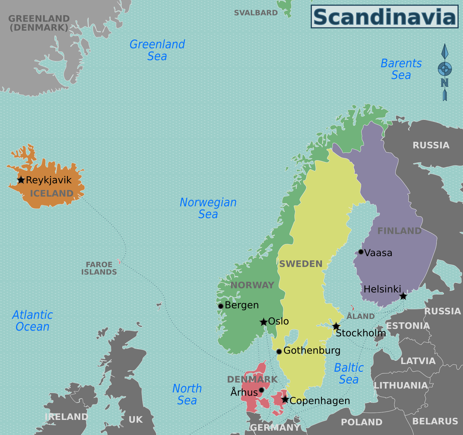
| Description | English: Travel regions of Scandinavia, English version |
| Date | |
| Source | File:Scandinavia regions map.svg |
| Author | Peter Fitzgerald, Stefan Ertmann, Júlio Reis, User:Mjchael |
| Permission (Reusing this file) | This file is licensed under the Creative Commons Attribution-Share Alike 3.0 Unported license.
|
File history
Click on a date/time to view the file as it appeared at that time.
| Date/Time | Thumbnail | Dimensions | User | Comment | |
|---|---|---|---|---|---|
| current | 20:07, 7 February 2013 | | 1,500 × 1,412 (536 KB) | Peterfitzgerald | gray Greenland |
| 06:53, 6 February 2013 |  | 1,500 × 1,412 (533 KB) | Peterfitzgerald | {{Information |Description ={{en|1=Travel regions of Scandinavia, English version}} |Source =File:Scandinavia regions map.svg |Author =Peter Fitzgerald, Stefan Ertmann, [[User:Tintazul|... |
File usage
The following page uses this file:
Global file usage
The following other wikis use this file:
- Usage on el.wikivoyage.org
- Usage on fi.wikipedia.org
- Usage on fi.wikivoyage.org
- Usage on he.wikivoyage.org
- Usage on hi.wikivoyage.org
- Usage on incubator.wikimedia.org
- Usage on ja.wikivoyage.org
- Usage on pl.wikipedia.org
- Usage on ro.wikivoyage.org
- Usage on uk.wikivoyage.org
- Usage on vi.wikivoyage.org
Metadata
🔥 Popular: Main PageSpecial:SearchAshburn (Virginia)Wiki Travel:AboutWiki Travel:HelpList of country calling codesSnorkelingWiki Travel:Travellers' pubSpecial:RecentChangesToronto/East EndQuezon City/CubaoUnited States of AmericaLagunaEastern IndiaNorth AmericaQuezon (province)ThailandEuropeEuropean route E39United KingdomIsraelAsiaGrand Trunk RoadJapanMuvattupuzhaWiki Travel:Upload fileKolkata/EsplanadeMiddle EastVietnamPhilippinesAluvaWestern IndiaJohor BahruIranItalyBuenos AiresCaviteDestinationsDanubeCroatiaFranceParisChinaCox's BazarBulgariaKikugawaEverest Base Camp TrekKeenjhar LakeSubicChukotkaSwanseaTurkish Republic of Northern CyprusIndiaSingaporeGermanyNew York CityLindosMinskHawaiiGundlupetMoroccoSindhi phrasebookGeorgia (country)AfricaTagaytayCalabarzonPolandPortugalGlace BayWorld War IIBohemiaHyderabad/EastUser:Gacor314TurkeyCanadaMauritiusCentral AmericaTraveling with a criminal historyMontenegro